Gibbs Island (South Shetland Islands) facts for kids

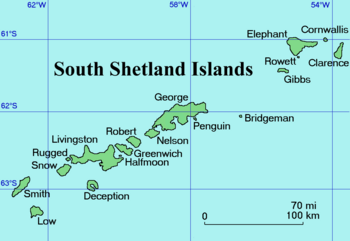
A map of the South Shetland Islands
|
|
|
Location of Gibbs Island
|
|
| Geography | |
|---|---|
| Location | Antarctica |
| Coordinates | 61°28′S 055°34′W / 61.467°S 55.567°W |
| Archipelago | South Shetland Islands |
| Area | 22 km2 (8.5 sq mi) |
| Length | 13 km (8.1 mi) |
| Width | 2 km (1.2 mi) |
| Administration | |
| Administered under the Antarctic Treaty System | |
| Demographics | |
| Population | Uninhabited |
| Ethnic groups | None |
Gibbs Island is a small island in Antarctica. It is part of the South Shetland Islands. The island is located about 25 kilometers (15 miles) southwest of Elephant Island. A man named James Weddell first used the name "Gibbs Island" on a map in 1825.
About Gibbs Island
Gibbs Island is long and narrow. It stretches about 13 kilometers (8 miles) from east to west. The island is about 2 kilometers (1.2 miles) wide. Its total area is around 22 square kilometers (8.5 square miles).
The Bransfield Strait is to the south of Gibbs Island. The Loper Channel is to its north. A narrow strip of land called The Spit connects the main part of Gibbs Island to Furse Peninsula in the east.
Home for Birds
A special area on Gibbs Island is known as an Important Bird Area (IBA). This means it is very important for birds. This area includes Furse Peninsula, The Spit, and a small part of Gibbs Island that is not covered in ice.
Many different kinds of birds live and breed here. About 1,700 pairs of Macaroni penguins make their nests on the island. There are also about 190 pairs of chinstrap penguins. More than 18,000 pairs of southern fulmars also breed here.
See also
 In Spanish: Isla Gibbs para niños
 | Ernest Everett Just |
 | Mary Jackson |
 | Emmett Chappelle |
 | Marie Maynard Daly |


