
Girvin, Saskatchewan facts for kids
Quick facts for kids
Girvin
|
|
|---|---|

King Street
|
|
| Motto(s):
Here People Count
|
|

Girvin, Saskatchewan
Location in Saskatchewan

Girvin, Saskatchewan
Location in Canada
|
|
| Country | Canada |
| Province | Saskatchewan |
| Region | Saskatchewan |
| Census division | 11 |
| Rural Municipality | Arm River |
| unincorporated (Hamlet) | December 19, 2005 |
| Area | |
| • Total | 3.8 km2 (1.5 sq mi) |
| Population
(2006)
|
|
| • Total | 20 |
| • Density | 5.3/km2 (14/sq mi) |
| Postal code |
S0G 1X0
|
| Area code(s) | 306 |
| Highways | Highway 11 Highway 749 |
| Waterways | |
Girvin is a small community in Saskatchewan, Canada. It is located right in the middle of two bigger cities, Regina and Saskatoon. You can find it along Highway 11, between the towns of Davidson and Craik.
Girvin used to be an official village. However, in 2005, it changed its status. Now, it is a smaller type of community called a hamlet. This means it is part of the larger rural area known as Arm River.
Contents
History of Girvin
How Girvin Got Its Name
Girvin was named after a man named John Alexander Girvin. He was a builder from Winnipeg. Mr. Girvin was famous for building many railroad stations across the Canadian prairies.
Early Settlement and Growth
The railway line, built by the Qu’Appelle, Long Lake, and Saskatchewan Railroad and Steamboat Company, came through this area in the 1890s. People started to settle here around 1902. Many of these early settlers came from Ontario.
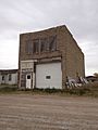
By 1905, Girvin had a school and a post office. Soon after, more businesses opened. There was a restaurant, a vet, a Massey-Harris farm equipment store, a lumber yard, a butcher, a hotel, a bank, and a blacksmith. The hotel even had three stories!
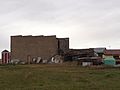
In 1907, Girvin had grown enough to become an official village. The community kept growing. By 1915, it was at its busiest. Girvin had three large grain elevators. These were big buildings used to store grain from local farms. The town also had sports teams for hockey, football, curling, and baseball.
Population Changes and Decline
Girvin's population was highest in 1926, with 151 people. But then it started to get smaller. By 1941, only 93 people lived there. The population went up a bit in the 1950s to 140 people. However, this didn't last long.
In the 1960s, the number of people living in Girvin began to fall again. By the 1980s, almost all the businesses were gone. Only a gas station and a garage were left. In 2004, the skating rink collapsed. Finally, on December 19, 2005, Girvin officially lost its village status.
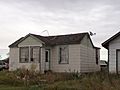
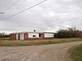
Girvin Today
Today, Girvin has about 20 residents. There are no businesses left in the community. However, Girvin is home to a large metal sculpture. It shows a bison and a Red River Cart. This artwork was created by Don Wilkins.
Population Information
In the 2021 Census, 25 people lived in Girvin. They lived in 11 homes. This was an increase from 2016, when 15 people lived there. The area of Girvin is about 0.78 square kilometers. This means there were about 32 people for every square kilometer in 2021.
Local Attractions
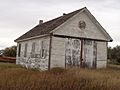
The Girvin Pump House
One interesting old building in Girvin is the Pump House. It was built in 1906. This building is on a small piece of land near the railway tracks. The Pump House used to provide water for horses. These horses would pull wagons full of grain into town. Some people also used its water for doing laundry.
The Girvin Pump House is special because it is the only one of its kind in Saskatchewan. It has been recognized as a Municipal Heritage Property since 1994.
Originally, a gas pump inside the building pulled water up to a tank at the top. The tower part of the Pump House looks like a smaller version of the water towers that were common at railway stations. Later, the gas pump was replaced with an electric one. When horses needed water, someone would pull a rope. This would release water into a trough for the horses. Over time, cars and tractors replaced horses on farms. Because of this, the Pump House was no longer needed.
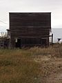
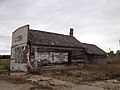
Gallery
-
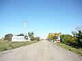
View down King Street
-
-
-
-
-
-
-
-
Sign for Girvin on Highway 11
.jpg)
.jpg)
.jpg)
.jpg)
.jpg)
.jpg)
.jpg)

