Glacial erratic boulders of Kitsap County, Washington facts for kids
Glacial erratic boulders of Kitsap County are huge rocks that were carried into Kitsap County, Washington by giant sheets of ice called glaciers during ancient ice ages. Imagine a massive ice conveyor belt picking up rocks and dropping them far away!
Kitsap County was shaped a lot by these glaciers. A scientist named J Harlen Bretz even said that if you travel across the Kitsap Peninsula, you'll notice hills and valleys formed by the dirt and rocks left behind by the ice. These special boulders are like clues from the past, showing us where the glaciers once were.
Contents
What Are Glacial Erratic Boulders?
Glacial erratics are rocks that are different from the bedrock (the natural rock) found in the area where they now rest. They are called "erratic" because they seem out of place. Think of them as giant visitors!
- How they move: Glaciers are like slow-moving rivers of ice. As they slide across the land, they pick up rocks of all sizes, from tiny pebbles to huge boulders.
- Where they come from: These rocks can be carried hundreds of miles from their original homes. When the glacier melts, it drops all the rocks it was carrying, leaving these erratics behind.
- Why they're important: Scientists study glacial erratics to understand how glaciers moved, how big they were, and how they shaped the landscape over thousands of years.
How Glaciers Shaped Kitsap County
During the last Ice Age, about 15,000 years ago, a huge glacier called the Vashon Lobe covered much of what is now Washington State, including Kitsap County.
- Powerful ice: This glacier was incredibly thick and heavy. It scraped away soil, carved out valleys, and pushed huge amounts of rock and dirt.
- Leaving clues: When the climate warmed and the glacier melted, it left behind a landscape full of hills made of glacial till (a mix of clay, sand, gravel, and boulders) and, of course, these impressive erratic boulders.
- A unique landscape: The way Kitsap County looks today, with its rolling hills and many lakes, is largely thanks to the powerful work of these ancient glaciers.
Cool Boulders in Kitsap County
Kitsap County is home to several famous glacial erratic boulders, each with its own story.
Frog Rock
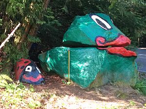
Frog Rock is a well-known boulder on Bainbridge Island. It got its name because, at one point, it looked a bit like a frog! In the 20th century, this large rock was actually dynamited (blown up) and moved off the road because it was in the way. Its pieces were then stacked, creating the landmark we see today. 47°41′46″N 122°31′24″W / 47.69612°N 122.52347°W
Haleets
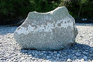
Haleets is another significant boulder located at Agate Point on Bainbridge Island. What makes this rock special are the ancient petroglyphs (rock carvings) found on its surface. These carvings are believed to be from before 400 CE, meaning they are over 1,600 years old! They offer a fascinating glimpse into the history of the people who lived in this area long ago. 47°43′07.1″N 122°32′40.1″W / 47.718639°N 122.544472°W
Illahee Preserve Erratic
This large erratic boulder can be found at the Almira parking lot within the Illahee Preserve. It's a great example of the many large rocks left behind by the glaciers in the area. 47°36′51″N 122°37′21″W / 47.6141°N 122.6225°W
Illahee Road Erratic
Another impressive boulder, the Illahee Road erratic, is described as an "extremely large erratic of volcanic rock." Its size and volcanic origin suggest it traveled a long way from its original home, carried by the powerful glaciers. 47°36′02″N 122°36′10″W / 47.60066°N 122.60268°W
Lone Rock
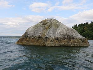
Lone Rock is a famous landmark that gives its name to the nearby community of Lone Rock. This massive boulder sits on the Hood Canal tidal flat, about 400 feet offshore. It's truly enormous, measuring at least 50 feet across! At low tide, you can often see it standing alone, a testament to the glacier's strength. 47°39′47″N 122°46′12″W / 47.66297°N 122.769916°W


