Lone Rock, Washington facts for kids
Quick facts for kids
Lone Rock
|
|
|---|---|

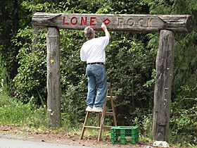
The Lone Rock community sign gets a touch-up. The corner of Anderson Hill Road and Seabeck Highway, 2 August 2011
|
|
| Country | United States |
| State | Washington |
| County | Kitsap |
| Time zone | UTC-8 (Pacific (PST)) |
| • Summer (DST) | UTC-7 (PDT) |
| ZIP code |
98383
|
| GNIS feature ID | 1528864 |
Lone Rock is a small, special place located on the coast of the Hood Canal in Kitsap County, Washington. It's called an "unincorporated community," which means it's a group of homes and people living together, but it doesn't have its own city government.
Contents
What Makes Lone Rock Special?
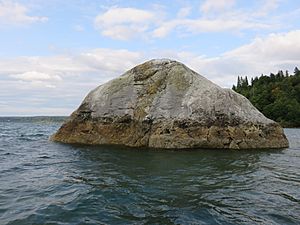
The community gets its unique name from a giant rock called the "Lone Rock." This rock is a "glacial erratic boulder." That's a fancy way of saying it's a huge rock that was moved a long, long time ago by a glacier. It sits on the muddy shore, about 400 feet away from the land.
Where is Lone Rock Located?
Lone Rock is one of several old, rural communities in the western part of Kitsap County. Other nearby communities include Seabeck, Holly, Camp Union, Crosby, and Hintzville.
Community Boundaries
The people who live in Lone Rock have a community club. They say Lone Rock stretches along the coast from Seabeck to Olympic View. Inland, it reaches Willamette Meridian Road and Newberry Hill Road.
Neighboring Areas
Little Beef Creek is often seen as the border between Lone Rock and Seabeck. This means Lone Rock includes areas around Big Beef and Little Anderson Creeks. It also covers smaller communities like Warrenville, Lawters Beach, and Anderson Landing.
 | Charles R. Drew |
 | Benjamin Banneker |
 | Jane C. Wright |
 | Roger Arliner Young |


