Glass Mountains facts for kids
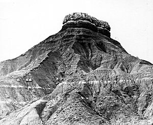
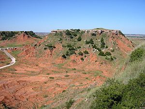
The Glass Mountains are a cool natural wonder in northwestern Oklahoma. They are also called the Gloss Mountains or Gloss Hills. Even though they are called "mountains," they are actually flat-topped hills called mesas and buttes. These formations are part of the Blaine Escarpment.
The Glass Mountains rise about 150 to 200 feet (46 to 61 meters) above the flat plains. The highest point is around 1,600 feet (488 meters) above sea level. You can find them stretching west along U.S. Route 412 from Orienta. They are located south of the Cimarron River. The name "Glass Mountains" comes from the shiny selenite crystals. These crystals sparkle on the slopes and tops of the mesas, making them look like glass!
Contents
How the Glass Mountains Formed
The Glass Mountains have a long and interesting history. They were shaped over millions of years.
Ancient Layers of Rock
During the Quaternary Period, which is the most recent one million years, layers of soil and rock were laid down. These layers are found along the major rivers in this area. They include sand, gravel, silt, clay, and even volcanic ash. These layers can be at least 100 feet (30 meters) thick.
The Permian Redbeds
Below these newer layers are much older rocks. These formed during the Permian Period, about 230 to 270 million years ago. This layer is made of red sandstone and shale. It can be very thick, from 1,000 to 4,500 feet (305 to 1,372 meters) deep! You can see gypsum on the rock surfaces that stick out. These red rocks are often called "redbeds." They tell us about a time when this area might have been a shallow sea or a dry, sandy desert.
History of the Glass Mountains
People have been amazed by the Glass Mountains for a long time.
Early Explorers
The first American explorers saw these sparkling formations in 1821. They called them the "Shining Mountains." The name "Glass Mountains" is said to come from an explorer named Thomas James. He visited the area in 1821 while on a trading trip along the Cimarron River. Later, in 1875, a mapmaker made a mistake. They wrote "Gloss Mountains" instead of "Glass Mountains." That's why you still hear both names today!
Part of the Cherokee Outlet
In the 1800s, this region became part of the Cherokee Outlet. This was a large area of land that belonged to the Cherokee Nation. In 1891, a botanist named George Walter Stevens studied the plants here. He collected many plant samples for his research. The University of Oklahoma still has thousands of samples he collected across the state. He may have found two types of cacti in the Glass Mountains area: Echinocereus caespitosus and Opuntia phaecantha.
Glass Mountains State Park
Today, you can visit the Glass Mountains! The state of Oklahoma runs the Glass Mountains State Park. It covers 640 acres (259 hectares). The park is about 6 miles (10 kilometers) west of Orienta, right on Highway 412.
Exploring the Park
At the park, you can hike to the top of one of the mesas. There's a path and stairs to help you climb up. Once you're at the top, you can enjoy amazing views of the surrounding plains. The park also has picnic tables where you can relax and eat. There's an informational kiosk that tells you more about the area. A small pond called Rattlesnake Lake is also nearby. It's a great place to learn about nature and see the unique landscape.
 | Selma Burke |
 | Pauline Powell Burns |
 | Frederick J. Brown |
 | Robert Blackburn |


