Glenville, Delaware facts for kids
Quick facts for kids
Glenville, Delaware
|
|
|---|---|

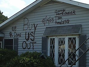
A destroyed Glenville home on October 2, 2003, two weeks after Tropical Storm Henri flooded the subdivision
|
|
| Country | United States |
| State | Delaware |
| County | New Castle |
| Elevation | 20 ft (6 m) |
| Population | |
| • Total | 0 |
| Time zone | UTC-5 (Eastern (EST)) |
| • Summer (DST) | UTC-4 (EDT) |
| Area code(s) | 302 |
| GNIS feature ID | 216920 |
Glenville was once a small neighborhood in Delaware, United States. It was located near the Red Clay Creek in New Castle County. Today, Glenville is known as a ghost town. This means no one lives there anymore. The community was abandoned because of serious flooding.
Contents
Why Glenville Became a Ghost Town
Glenville was built in an area that often flooded. This area is called a floodplain. Because of its location, the neighborhood was always at risk when heavy rains came.
Where Was Glenville Located?
Glenville was a small community on Bread and Cheese Island. It was on the east side of the Red Clay Creek. This spot was just south of Delaware Route 4 near Stanton.
The Big Floods of 1999 and 2003
Glenville experienced major floods several times. In 1999, Hurricane Floyd caused a lot of damage. Then, on September 15, 2003, Tropical Storm Henri brought even more severe flooding. Many homes were badly damaged or destroyed.
The Community is Abandoned
After the 2003 flood, the state and local governments stepped in. They decided to buy the houses from the people living there. This helped families move to safer places. By 2004, the entire community was empty. The buildings were torn down starting in 2005.
Glenville Today
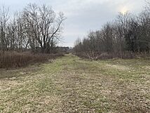
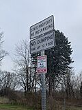
As of 2023, Glenville is still an abandoned area. Fences have been put up to keep people from entering. This is to prevent trespassers and ensure safety. You can still see some remains of the old roads.
 | William M. Jackson |
 | Juan E. Gilbert |
 | Neil deGrasse Tyson |


