Glouster, Ohio facts for kids
Quick facts for kids
Glouster, Ohio
|
|
|---|---|
|
Village
|
|

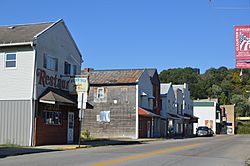
High Street downtown
|
|

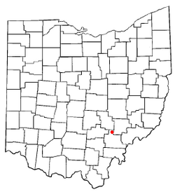
Location of Glouster, Ohio
|
|

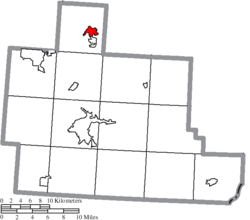
Location of Glouster in Athens County
|
|
| Country | United States |
| State | Ohio |
| County | Athens |
| Township | Trimble |
| Area | |
| • Total | 1.32 sq mi (3.43 km2) |
| • Land | 1.31 sq mi (3.39 km2) |
| • Water | 0.01 sq mi (0.04 km2) |
| Elevation | 686 ft (209 m) |
| Population
(2020)
|
|
| • Total | 1,659 |
| • Estimate
(2023)
|
1,629 |
| • Density | 1,267.38/sq mi (489.21/km2) |
| Time zone | UTC-5 (Eastern (EST)) |
| • Summer (DST) | UTC-4 (EDT) |
| ZIP code |
45732
|
| Area code(s) | 740 |
| FIPS code | 39-30674 |
| GNIS feature ID | 2398982 |
Glouster is a small village located in Athens County, Ohio, United States. It is part of Trimble Township. In 2020, about 1,659 people lived here. Glouster is also close to Burr Oak State Park, a popular spot for outdoor activities.
Contents
History of Glouster
Glouster was once known by a different name, Sedalia. In 1886, the village changed its name to Glouster. This new name was chosen to honor Gloucester, England. A post office has been serving the community since 1887.
Geography and Nature
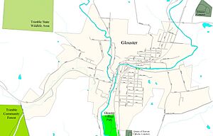
Glouster is situated along a waterway called Sunday Creek. The entire village lies within the area drained by Sunday Creek. This means that all the rain and water in Glouster eventually flows into this creek. The land here is mostly flat plains or old river terraces.
The United States Census Bureau reports that Glouster covers about 1.34 square miles (3.47 square kilometers). Most of this area is land, with a very small part being water.
The region around Glouster has gentle, rolling hills and many wooded areas. These are part of the Allegheny Plateau, a high, flat area that was not shaped by glaciers. You can find several public and semi-public natural areas nearby. These include the Trimble State Wildlife Area and the Sunday Creek State Wildlife Area. There is also the Trimble Community Forest, the Wayne National Forest, and Burr Oak State Park.
Glouster Community Park is a local park located next to Ohio State Route 13. It sits between the highway and Sunday Creek, at the southern end of the village.
Population of Glouster
| Historical population | |||
|---|---|---|---|
| Census | Pop. | %± | |
| 1900 | 2,155 | — | |
| 1910 | 2,527 | 17.3% | |
| 1920 | 3,140 | 24.3% | |
| 1930 | 2,903 | −7.5% | |
| 1940 | 2,847 | −1.9% | |
| 1950 | 2,327 | −18.3% | |
| 1960 | 2,255 | −3.1% | |
| 1970 | 2,121 | −5.9% | |
| 1980 | 2,211 | 4.2% | |
| 1990 | 2,001 | −9.5% | |
| 2000 | 1,972 | −1.4% | |
| 2010 | 1,791 | −9.2% | |
| 2020 | 1,659 | −7.4% | |
| 2023 (est.) | 1,629 | −9.0% | |
| U.S. Decennial Census | |||
In 2010, the village of Glouster had a population of 1,791 people. There were 720 households living in the village at that time. The population density was about 1,346 people per square mile (520 people per square kilometer).
Most of the people living in Glouster were White (96.1%). A smaller number were African American (1.4%), Native American (0.1%), or Asian (0.2%). About 2.1% of the population identified as being of two or more races. Hispanic or Latino people made up 0.8% of the population.
The average age of people in Glouster in 2010 was 35.8 years. About 27.7% of residents were under 18 years old.
Economy and Jobs
Glouster's economy has been supported by various activities over the years. A deep mine is located north of the town. While the main mining operations moved east of Burr Oak State Park, the loading station for the coal is still in Glouster. This is because of its convenient location near the railroad.
Local schools, like Trimble High School and Middle School, provide jobs for many people. Another important employer is Frog Ranch Foods. The Hocking-Athens-Perry Community Action Programs (HAPCAP) also offers local employment.
Tourism from nearby Burr Oak State Park helps the economy. Hunting in the public lands around Glouster also brings visitors and supports local businesses. The village itself owns and operates its own electrical and water services. They buy electricity from American Electric Power and water from the Sunday Creek Water District.
Village Infrastructure
Transportation in Glouster
Two Ohio state highways, Route 13 and Route 78, both run through Glouster. Another state route, 329, starts in the nearby village of Trimble. A main railroad line, part of the Norfolk Southern Railway, also passes through Glouster. This railway also helps transport coal from the nearby Buckingham Coal Company mine.
Utilities and Services
The village of Glouster manages its own electricity and water services for its residents. Sewage treatment for the village is handled by a plant located in nearby Trimble. The Hocking-Athens-Perry Community Action Program (HAPCAP) helps the community in many ways. They provide jobs, help with energy bills (like HEAP and PIPP), and offer programs to make homes more energy-efficient.
Education
Students living in Glouster attend schools within the Trimble Local School District. This includes Trimble High School. Glouster also has its own public library. It is a branch of the Athens County Public Libraries system.
See also
 In Spanish: Glouster (Ohio) para niños
 | Claudette Colvin |
 | Myrlie Evers-Williams |
 | Alberta Odell Jones |


