
Sunday Creek (Ohio) facts for kids
Quick facts for kids Sunday Creek |
|
|---|---|

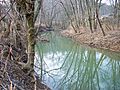
Sunday Creek in Glouster, Ohio in 2006
|
|
| Country | United States |
| State | Ohio |
| Counties | Perry, Athens |
| Physical characteristics | |
| Main source | Perry County, Ohio, approximately 5 mi (8.0 km) north of Corning Approx. 800 ft (240 m) 39°40′28″N 82°05′37″W / 39.67444°N 82.09361°W |
| River mouth | Hocking River at Chauncey, Ohio 640 ft (200 m) 39°23′32″N 82°07′24″W / 39.39222°N 82.12333°W |
| Length | 27.2 mi (43.8 km) |
| Basin features | |
| Basin size | 139 sq mi (360 km2) |
Sunday Creek is a stream in southeastern Ohio, United States. It flows for about 27 miles (44 kilometers) and is a smaller river that joins the Hocking River.
The water from Sunday Creek eventually flows into the Ohio River and then into the Mississippi River. This means Sunday Creek is part of the huge watershed of the Mississippi River. It drains an area of 139 square miles (360 square kilometers) in a mostly rural part of the Allegheny Plateau.
People in the area say the creek got its name because early settlers arrived there on a Sunday in 1802. There's even a nearby stream called Monday Creek!
Contents
Where Does Sunday Creek Flow?
Sunday Creek starts in the southeastern part of Perry County, Ohio. It then flows south into northern Athens County, Ohio.
Along its path, the creek passes through several towns. These include Rendville, Corning, Glouster, Trimble, Jacksonville, and Millfield. Finally, it reaches Chauncey, Ohio, where it joins the Hocking River.
Main Branches of Sunday Creek
Sunday Creek has two main branches that feed into it:
- East Branch Sunday Creek: This branch is about 15.5 miles (25 kilometers) long. It starts in Perry County and flows through Morgan County, Ohio. In Athens County, a dam called Tom Jenkins Dam was built on this branch in 1950. This dam created a lake called Burr Oak Lake, which is now part of Burr Oak State Park.
- West Branch Sunday Creek: This branch is about 14 miles (22.5 kilometers) long. It also starts in Perry County and flows south. It joins the main Sunday Creek in Glouster.
Other smaller streams that flow into Sunday Creek include Greens Run, Mud Fork, and Johnson Run. These streams are always flowing and drain the land to the west of the creek.
How Mining Affected the Creek

For a long time, coal mining was a very common activity in the area around Sunday Creek. Both underground mines and surface mines operated there.
In 1997, a study by the Ohio Environmental Protection Agency found a big problem. The lowest 13 miles (21 kilometers) of Sunday Creek were badly damaged. The water was too acidic because of something called acid mine drainage. This made it impossible for most aquatic life (like fish and insects) to live in that part of the creek. During times when the water level is low, the lower parts of the creek often look orange because of this acid drainage.
Helping Sunday Creek
As of 2012, a group called the Sunday Creek Watershed Group is working to fix these problems. They want to improve the water quality and help the plants and animals in the creek's watershed. This group is supported by Rural Action, a non-profit organization in southeastern Ohio.
Images for kids
-
Sunday Creek in Glouster, Ohio in 2006
-
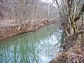
Sunday Creek in Glouster in 2006
