
Gmunden (district) facts for kids

The Gmunden District (in German: Bezirk Gmunden) is an important part of the state of Upper Austria in Austria. It is the largest district in Upper Austria, covering a huge area of about 1,433 square kilometers (553 square miles). The Gmunden District shares its northern borders with the Vöcklabruck, Wels-Land, and Kirchdorf an der Krems districts. To the south, it borders the Styrian district of Liezen. On its western side, it touches the Salzburgerland districts of Sankt Johann im Pongau, Hallein, and Salzburg-Umgebung.
The main office and administrative center for the Gmunden District are located in the town of Gmunden.
Most of the Gmunden District is covered by forests, making up about 54% of its total area. Around 17% of the land is used for farming. About 3.8% of the district is covered by water, including beautiful lakes like the Traunsee and the Hallstätter See.
How the Gmunden District Was Formed
The Gmunden District was officially created in 1896. Before that, the areas were managed as two separate legal regions, known as juridical districts. These were the juridical districts of Bad Ischl and Gmunden. They were then combined to form the single Gmunden District we know today.
Towns and Villages in Gmunden
The Gmunden District is made up of 20 different towns and villages. Each of these places has its own unique charm and history.
- Altmünster
- Bad Goisern
- Bad Ischl
- Ebensee
- Gmunden
- Gosau
- Grünau im Almtal
- Gschwandt
- Hallstatt
- Kirchham
- Laakirchen
- Obertraun
- Ohlsdorf
- Pinsdorf
- Roitham
- Sankt Konrad
- Sankt Wolfgang im Salzkammergut
- Scharnstein
- Traunkirchen
- Vorchdorf
Images for kids
-
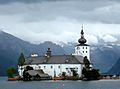
Schloss Ort in Gmunden
-
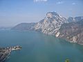
Traunstein, Traunsee and Traunkirchen
-
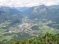
Bad Ischl


.jpg)

See also
 In Spanish: Distrito de Gmunden para niños
