Godahl, Minnesota facts for kids
Quick facts for kids
Godahl
|
|
|---|---|

|
|
| Country | United States |
| State | Minnesota |
| County | Brown Watonwan |
| Elevation | 1,043 ft (318 m) |
| Time zone | UTC-6 (Central (CST)) |
| • Summer (DST) | UTC-5 (CDT) |
| ZIP code |
56081
|
| Area code(s) | 507 |
| GNIS feature ID | 654726 |
Godahl is a small, quiet place in Minnesota, USA. It's not a big city or even a town with its own government. Instead, it's an unincorporated community, which means it's a group of homes and buildings that are part of two different counties: Brown and Watonwan.
Where is Godahl?
Godahl is special because it sits right on the border between Brown and Watonwan counties. This means it's actually in two counties at once!
You can find Godahl between the towns of Sleepy Eye and St. James. It's located right on Minnesota State Highway 4, where it meets County Roads 6 and 10.
The Story of Godahl
Godahl was first settled by people who came from Norway. They named their new home "Godahl" to honor their old home, which was called Gode Dahl. This name means "Good Valley."
For a while, Godahl had its own post office, from 1894 to 1907. It also had a train station for the Chicago, St. Paul, Minneapolis and Omaha Railway. But the community didn't grow into a big town.
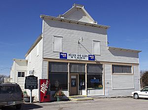
For many years, the most important building was the Godahl Store. This store was a special kind of business called a cooperative. This means it was owned and run by the people who used it, like a club where everyone helps out. The store was built in 1894 and is so important that it's listed on the National Register of Historic Places. Sadly, the Godahl Store closed its doors on December 31, 2016.
 | William L. Dawson |
 | W. E. B. Du Bois |
 | Harry Belafonte |


