Goicoechea (canton) facts for kids
Quick facts for kids
Goicoechea
|
|||
|---|---|---|---|
|
|||
| Country | |||
| Province | San José | ||
| Creation | 6 August 1891 | ||
| Head city | Guadalupe | ||
| Districts | |||
| Government | |||
| • Type | Municipality | ||
| • Body | Municipalidad de Goicoechea | ||
| Area | |||
| • Total | 31.7 km2 (12.2 sq mi) | ||
| Elevation | 1,364 m (4,475 ft) | ||
| Population
(2011)
|
|||
| • Total | 115,084 | ||
| • Estimate
(2022)
|
132,104 | ||
| • Density | 3,630/km2 (9,403/sq mi) | ||
| Time zone | UTC−06:00 | ||
| Canton code | 108 | ||
Goicoechea is a canton (like a county or a district) located in the San José province of Costa Rica. It's an important area within the country.
Contents
A Look Back: History
Goicoechea became an official canton on August 6, 1891. This happened through a special rule called decree 66.
Where is Goicoechea? Geography
Goicoechea covers an area of about 31.7 square kilometers. It sits at an average height of 1,364 meters above sea level.
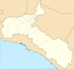
This canton has a long, curved shape. It stretches through the areas just north of San José, the capital city. Goicoechea slowly climbs up into the Central Mountain Range. Its eastern edge is found between two rivers: the Durazno River to the north and the Tiribí River to the south.
Parts of Goicoechea: Districts
The canton of Goicoechea is divided into the following districts:
People of Goicoechea: Demographics
| Historical population | |||
|---|---|---|---|
| Census | Pop. | %± | |
|
Instituto Nacional de Estadística y Censos |
|||
In 2022, it was estimated that about 132,104 people lived in Goicoechea. This number is higher than the 115,084 people counted during the 2011 census.
A report by the United Nations Development Programme shows that Goicoechea has a Human Development Index (HDI) score of 0.758. The HDI is a way to measure how well people are doing in terms of health, education, and living standards. Goicoechea ranks 10th in its province for this score.
Getting Around: Transportation
Roads
Several important roads pass through Goicoechea. These routes help people travel within the canton and to other parts of Costa Rica:
Trains
The Interurbano Line, run by Incofer, also travels through this canton. This train line helps connect different urban areas.
See also
 In Spanish: Cantón de Goicoechea para niños


