Goose Hollow, Portland, Oregon facts for kids
Quick facts for kids
Goose Hollow
|
|
|---|---|
|
Neighborhood
|
|
| Country | United States |
| State | Oregon |
| City | Portland |
| Area | |
| • Total | 0.45 sq mi (1.17 km2) |
| Population
(2000)
|
|
| • Total | 5,433 |
| • Density | 12,030/sq mi (4,644/km2) |
| Housing | |
| • No. of households | 3792 |
| • Occupancy rate | 91% occupied |
| • Owner-occupied | 540 households (14%) |
| • Renting | 3252 households (86%) |
| • Avg. household size | 1.43 persons |
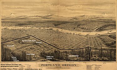
Goose Hollow is a neighborhood in southwest Portland, Oregon. It got its unique name because early residents let their geese roam freely. They wandered in a deep valley called Tanner Creek Gulch. This gulch was about 50 feet (15 meters) deep and 20 blocks long. It carried water from Tanner Creek into Couch Lake.
Over 100 years ago, Tanner Creek was buried underground. It still drains the West Hills today. The deep valley, Tanner Creek Gulch, was also filled in. The only part of the original "hollow" that remains is Tanner Creek Canyon. The Sunset Highway (US-26) now passes through this canyon. The famous Vista Bridge also crosses over it.
A historically important road called Canyon Road connected to Jefferson Street under the Vista Bridge. It was once known as "The Great Plank Road." This road went through Tanner Creek Canyon, which gave it its name. In the 1960s, parts of Canyon Road were raised using dirt from the Interstate 405 construction. Now, it's just a section of Highway 26. The name "Goose Hollow" wasn't used much for many years. But in 1967, former mayor Bud Clark opened his pub, The Goose Hollow Inn. He wanted to help people remember and appreciate the neighborhood again. Bud Clark himself lived in Goose Hollow.
Contents
Exploring Goose Hollow
Goose Hollow is right next to several other Portland areas. These include Downtown Portland, Arlington Heights, the Pearl District, and Washington Park. Some important places are located here. You can find Providence Park, the Multnomah Athletic Club, and Lincoln High School. Lincoln High is the oldest high school in the Pacific Northwest.
The neighborhood includes areas like King's Hill, Vista Ridge, and Gander Ridge. King's Hill is separated from Vista Ridge by the Tanner Creek Canyon. The Vista Bridge crosses this canyon. Vista Ridge is where the Vista Ridge Tunnels are located. It is separated from Gander Ridge by Cable Car Canyon. From 1890 to 1905, a huge bridge for cable cars crossed this canyon. It carried cable cars up to Portland Heights.
The boundaries of Goose Hollow stretch from Burnside Street in the north to the lower parts of the West Hills (also called the Tualatin Mountains) in the south. From east to west, it goes from I-405 to Washington Park.
Things to See and Do
The MAX Light Rail train system runs through Goose Hollow. It has stops at Providence Park and Goose Hollow/SW Jefferson St stations. Two major highways also serve the neighborhood. Interstate 405 separates Goose Hollow from Downtown Portland. U.S. Route 26 passes through the neighborhood, including the Vista Ridge Tunnels.
The Goose Hollow Inn is a well-known tavern on SW Jefferson Street. It was once owned by former mayor Bud Clark.
Important Buildings
- Civic Tower - This building is located at 1926 West Burnside St.
Famous People from Goose Hollow
Many interesting people have lived in Goose Hollow over the years. Some of them include:
- Daniel H. Lownsdale
- Charles Erskine Scott Wood
- Congresswoman Nan Wood Honeyman
- Marie Equi
- John Reed
- Abigail Scott Duniway
- Julius Meier
- Lendon Smith
- Pietro Belluschi
- Minor White
- Milton Wilson
- Chuck Palahniuk
- Former Mayor Bud Clark
- Ken Shores
- George Johanson
- Jean Auel
Goose Hollow in Movies and TV
Goose Hollow has appeared in popular culture. The first scenes of the 2004 movie What the Bleep Do We Know!? were filmed here. They showed views of the Vista Bridge and the Goose Hollow/SW Jefferson St (MAX station). In 2010, the main title shot for the TV show Portlandia was taken from Goose Hollow's Vista Bridge.
 | Selma Burke |
 | Pauline Powell Burns |
 | Frederick J. Brown |
 | Robert Blackburn |


