Goose Island (District of Columbia) facts for kids

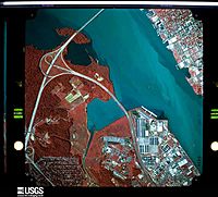
1983 false-color aerial photograph of the Potomac River. The small red speck, and the visible sandbar to its left, are parts of Goose Island. South is up and north is down.
|
|
| Geography | |
|---|---|
| Location | Potomac River, Washington, D.C. |
| Coordinates | 38°48′30.4″N 77°01′47.9″W / 38.808444°N 77.029972°W |
| Total islands | 3 |
| Administration | |
|
United States
|
|
| Demographics | |
| Population | 0 |
Goose Island is a tiny piece of land located in the Potomac River near Washington, D.C. in the United States. It is known as a vanishing island, which means it often disappears under the water. It's mainly a mudflat, a flat area of muddy land that only shows itself when the water level is low.
Contents
Where is Goose Island?
Goose Island is found in the southwest part of Washington, D.C. It sits right where Oxon Creek flows into the Potomac River. You can find it roughly between Oronoco Bay in Alexandria, Virginia and a place called Marbury Point. Marbury Point is now part of the Blue Plains Advanced Wastewater Treatment Plant, a big facility that cleans water.
What is a Vanishing Island?
A vanishing island like Goose Island is not always visible. It's a landform that is sometimes above water and sometimes submerged. This can happen because of tides, river levels, or even changes in the riverbed. Goose Island is mostly a mudflat, meaning it's made of soft mud and sand.
How is Goose Island Formed?
Goose Island is in a shallow part of the Potomac River. This area is sometimes used to deposit "dredging spoils." Dredging is when machines dig up mud, sand, and other materials from the bottom of a river or harbor to make it deeper for boats. The "spoils" are the materials that are dug up. These materials are then placed in other areas, and over time, they can build up and form new land or add to existing mudflats like Goose Island.
Goose Island on Maps
Maps made by the National Oceanic and Atmospheric Administration (NOAA) show Goose Island. These maps, called nautical charts, help sailors navigate. They show that Goose Island is part of a larger shallow area. This shallow area stretches south past the Woodrow Wilson Bridge and into Maryland.
 | Claudette Colvin |
 | Myrlie Evers-Williams |
 | Alberta Odell Jones |

