Oxon Creek facts for kids
Quick facts for kids Oxon Creek |
|
|---|---|

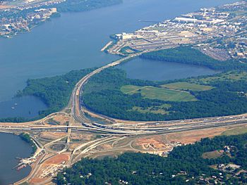
Anacostia Freeway Crossing Oxon Creek to join the Beltway (2007) - Wilson Bridge is to the left
|
|
| Country | United States |
| Location | Prince George's County, Maryland and Washington, D.C. |
| Physical characteristics | |
| River mouth | Potomac River 0 feet (0 m) |
| Length | 1.5 miles (2.4 km) |
| Basin features | |
| Tributaries |
|
Oxon Creek is a small stream that flows into the Potomac River. It's located right on the border between Washington, D.C. and Prince George's County, Maryland. You can find it just north of the Woodrow Wilson Bridge, which is part of Interstate 495 (Capital Beltway).
The creek starts where two smaller streams, Oxon Run and Barnaby Run, meet. Barnaby Run is sometimes called Winkle Doodle Run. Oxon Creek begins in D.C. and then flows about 1.5 miles (2.4 km) southwest into Maryland. It eventually empties into the Potomac River near Goose Island. This island is actually a sandbar that is often covered by water. It's located across from the city of Alexandria, Virginia.
Before it reaches the Potomac, Oxon Creek gets wider and forms a larger area called Oxon Cove. This cove is also split between Maryland and Washington, D.C. Most of the creek is inside Oxon Cove National Park. Only a small part in D.C. and a section near the Blue Plains Advanced Wastewater Treatment Plant are outside the park.
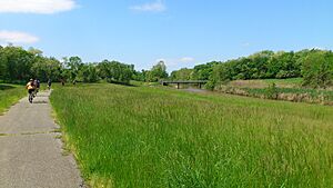
Two bridges cross Oxon Creek. The Anacostia Freeway crosses it where the creek becomes a tidal stream, meaning its water level changes with the ocean tides. A smaller bridge, part of the Oxon Hill Farm Trail, crosses the creek where it is still narrow.
Contents
What's in a Name? The History of Oxon Creek's Name
The name "Oxon" might seem a bit unusual. It could be an old way of spelling a word, or it might be a reference to Oxfordshire in England. Before 1898, maps usually called it "Oxen Creek."
Many people often confuse Oxon Creek with Oxon Run, and they sometimes call both by the name Oxon Run. However, the U.S. Geological Survey (USGS) officially started labeling it as Oxon Creek in 1892.
Other Names for Oxon Creek Over Time
Over the years, Oxon Creek has been known by several different names. The Geographic Names Information System lists these historical names:
- Isedores Creeke
- Isidoras Creek
- Oxen Creek
- Saint Isedores Creeke
- Saint John Creeke
- Saint Johns Creeke
A Look Back: The History of Oxon Creek and Its Surroundings
The area around Oxon Creek was mostly undeveloped for a long time. That changed around the time of World War II. The town of Forest Heights was built along the southeast side of the creek during this period.
After a big storm called Hurricane Connie in 1955, the U.S. Army Corps of Engineers started a project to control flooding along Oxon Creek. They changed the creek's path and made it wider, about 100 feet (30 meters) across. They also built a concrete structure to control the water flow. Work on this project began in 1961.
The first bridge over the creek, the Anacostia Freeway bridge, opened in 1961. It was later rebuilt around the year 2000. The trail bridge, which is used by hikers and bikers, was built in the 1970s.
Today, Oxon Creek is almost entirely located within Oxon Cove Park and Oxon Hill Farm. These areas are managed by the National Park Service. Planning for this park began in 1969.
Exploring Oxon Creek: The Trails
There are several trails that run alongside Oxon Creek and cross it on a bridge. These trails offer a great way to explore the area.
The Oxon Creek Trail
The Oxon Creek Trail starts in Forest Heights, Maryland, at the intersection of Oxon Run Drive and Audrey Lane. It crosses over a small, unnamed stream called the Forest Heights tributary. Then, it follows Oxon Creek for about half a mile. It eventually connects with the Oxon Hill Hiker-Biker Trail inside Oxon Cove National Park.
The Oxon Hill Hiker-Biker Trail
The Oxon Hill Hiker-Biker Trail is about 2 miles (3.2 km) long. It begins at the parking lot for Oxon Hill Farm. From there, it goes down a hill to the southeast corner of Oxon Cove. The trail then follows the south and east sides of Oxon Creek until it meets the Oxon Creek Trail.
At this meeting point, the trail crosses Oxon Creek on one of the two bridges over the creek. It then goes through parkland and into Washington, D.C., ending at DC Village Lane, SW.
How the Trails Were Developed
The trails around Oxon Cove have an interesting history. In the 1970s, people who rode bikes to work used old access roads and a raised path that was built for landfill operations. When the landfill closed, cyclists asked for a proper trail, and one was built in 1978.
Before 2010, a bridge over the Forest Heights tributary was often washed out by high water, making it difficult to cross. In 2011, the part of the trail within D.C. was rebuilt. In the same year, a new bridge was built to connect the Oxon Creek Trail and the Hiker-Biker path, making it easier for everyone to enjoy the area.
 | William L. Dawson |
 | W. E. B. Du Bois |
 | Harry Belafonte |


