Oxon Run facts for kids
Quick facts for kids Oxon Run |
|
|---|---|

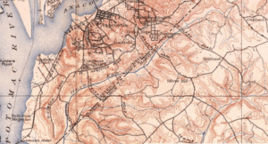
Oxon Run in 1900
|
|
| Country | United States |
| States | Maryland |
| Districts | Washington, D.C. |
| County | Prince George's County, Maryland |
| Physical characteristics | |
| Main source | Coral Hills, MD 38°51′33″N 76°54′49″W / 38.859177°N 76.913568°W |
| River mouth | Oxon Creek 38°49′01″N 77°00′25″W / 38.8170718°N 77.0068699°W |
| Length | 7 miles (11 km) |
| Width |
|
| Depth |
|
| Basin features | |
| River system | Potomac River |
| Basin size | 5,312 acres (21.50 km2) |
| Landmarks | Naylor Road Station, Oxon Run Parkway |
Oxon Run is a stream that flows into Oxon Creek and then into the Potomac River. It runs through Prince George's County, Maryland, and Washington, D.C..
Long ago, maps often called this stream "Oxen Run." In 1892, the U.S. Geological Survey (USGS) also used this spelling. Later that year, they changed it to "Oxon Run." Other mapmakers followed this new spelling, but no one is sure why the change happened.
Sometimes, people and government groups treat Oxon Creek as just a part of Oxon Run. However, the USGS still sees them as two separate streams. The USGS started calling the lower part "Oxon Creek" in 1892.
Where is Oxon Run Located?
The stream starts in the Coral Hills area of Prince George's County, Maryland. It begins near Francis Scott Key Elementary School. From there, it flows west and then south for about 7 miles (11 km).
It joins with another stream called Barnaby Run. Together, they form Oxon Creek, which eventually flows into the Potomac River and the Chesapeake Bay. The area of land that drains water into Oxon Run is called its watershed. This watershed covers about 5,312 acres (21.5 km²) in Prince George's County. It also covers about 3,968 acres (16.06 km²) in Washington, D.C.
Oxon Run's Journey Through Maryland
In Prince George's County, Oxon Run mostly flows through open land. It starts in Coral Hills and goes into a pond that manages stormwater. Here, it mixes with water from a drainpipe coming from a shopping center.
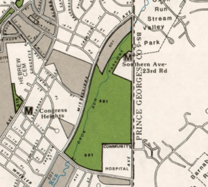
The stream then flows through a forest in a floodplain. This path is sometimes broken by concrete tunnels or metal pipes. It also runs beside and under Pennsylvania Avenue. South of Pennsylvania Avenue, it passes by Cedar Hill and Lincoln Memorial cemeteries. It then goes through a park area, including Suitland Parkway and Oxon Run Valley Park. It flows under Suitland Parkway at Naylor Road and then under Southern Avenue, entering Washington, D.C.
Oxon Run's Journey Through Washington, D.C.
Once in D.C., Oxon Run flows through parkland. It enters the Oxon Run Parkway, which is managed by the National Park Service. This parkway has special northern magnolia bogs, which are rare. The land here used to be part of Camp Simms.
The stream then goes through Oxon Run Park, where it flows in a concrete channel. After passing under South Capitol Street, it returns to a natural channel. This part is between a forested hill and an old landfill. Just inside the D.C. boundary, it meets Barnaby Run and officially becomes Oxon Creek. In D.C., about 38 sewer systems release stormwater into Oxon Run.
How the Stream Has Changed Over Time
Oxon Run used to be a winding stream with gravel and sand at its bottom. But in the 1900s, it changed a lot. This was due to projects to control floods and the growth of cities in its watershed. Many smaller streams that fed into Oxon Run were turned into storm drains.
History of Oxon Run Valley
Before the 1900s, the Oxon Run valley was mostly quiet. It was filled with large farms and fruit orchards. At first, it was all part of Maryland. But in 1800, it was split between Maryland and the new District of Columbia.
In 1855, much of the land was owned by George Washington Young. He was a large slave owner in the District. His family had owned land in the valley since the 1700s. Within D.C., Oxon Run was in Washington County until the whole District was joined together in 1871. Many different families owned land in the valley. Some of their names are still used for streets today, like Wheeler Road and Livingston Road.
Growth and Development in the Valley
The first big changes in the valley happened during the American Civil War. The Army built forts on the hills above Oxon Run. As the city grew, new roads were built into the valley. Wheeler Road was extended across the stream in 1870. Two years later, the first bridge was built there.
More roads and bridges were built around this time. These included Marlboro Road, Suitland Road, and Naylor Road. All these roads were built after the Civil War, by 1878.
Over time, the farms and orchards gave way to the city's needs. The first new developments were two cemeteries and a military base. In 1895, Cedar Hill Cemetery opened along the stream. In 1904, the military built a firing range called Camp Simms in D.C. Even with these changes, in 1912, the stream was still described as flowing through a "gentle, graceful valley." In 1927, Lincoln Memorial Cemetery opened nearby. It was one of the first cemeteries in the area to allow African-Americans. Quarter Avenue in Maryland was built across the stream before 1938. Despite these changes, the area stayed mostly rural until World War II.
Protecting the Green Space
In the 1920s, the government started to protect green spaces around Washington. They focused on stream and river valleys, including Oxon Run. In 1924, Congress created the National Capital Park and Planning Commission (NCPPC). Their goal was to create parks and playgrounds for the capital city. By 1926, they planned a "parkway" system that would include the Oxon Run valley.
By 1930, the NCPPC began buying narrow strips of land along the stream for the "Oxon Run Parkway." A report also suggested Oxon Run could be a water source for Maryland. It said a sewer was needed to keep the water clean. After a flood in 1937, the NCPPC bought more land to widen the parkway. This stopped homes from being built in the flood area. It also allowed for a sewer project, completed in 1939. The NCPPC kept buying land until 1944. By then, the Parkway covered almost all of the D.C. section.
The Camp Simms firing range closed in 1953 because the city was growing around it. In 1958, 94 acres of the site were added to the Oxon Run Parkway. In the 1960s, a landfill was built along the stream. It was meant to become a park, but it never did.
Expanding Protection into Maryland
After World War II, efforts to protect the valley spread into Maryland. In 1946, President Truman signed a law to preserve the Oxon Run valley in Maryland. By 1953, the Maryland-National Capital Park and Planning Commission (M-NCPPC) had bought 5 acres and planned to buy more. In 1955, 17 more acres were bought for the Hillcrest Heights Recreation Center. In 1961, M-NCPPC bought the Oxon Run Golf Course. It was the first public golf course in Prince George's County, built in 1954. It closed in 1986.
Changing the Stream's Path
While the land around it was protected, Oxon Run itself was changed. Sections near the Potomac and the cemeteries were straightened before World War II. The stream was also straightened near Suitland Parkway by 1949. In 1959, as Pennsylvania Avenue was extended, the stream was moved and put into a concrete channel.
After a big storm in 1972, 2,800 feet (850 m) of the stream were dug out. The biggest change happened in 1978 and 1979. The D.C. Stormwater Management Authority built a 7,920-foot (2,410 m) long concrete channel for the stream. More recently, in 1995, WMATA (the Metro system) stabilized the stream near Suitland Parkway. This allowed them to build supports for the Naylor Road Station.
Roads and Transportation in the Valley
The sewer project in the 1930s and population growth led to more housing in the Oxon Run valley. New roads were built to connect these areas. South Capitol Street, Branch Avenue, and Brooks Drive got bridges over the stream between 1938 and 1942.
From 1943 to 1944, the military built the Suitland Parkway. It crossed Oxon Run to connect two air force bases. Between 1947 and 1951, more bridges were built for other roads. In 1959, Pennsylvania Avenue was extended over the stream. The last road bridge over the stream, at Southern Avenue, was built in 1980. The newest transportation project was the Metro's Green Line. It was built from 1995 to 2001. It goes under Oxon Run through a tunnel and crosses it twice more.
Parks and Recreation
In 1971, the land between 13th Street and South Capitol became Oxon Run Park. It was managed by the D.C. government. The land closer to Southern Avenue remained the Oxon Run Parkway, managed by the National Park Service. In 1975, officials planned improvements for the park. These plans included jogging and bike trails, picnic areas, and sports fields. Work started in 1984 and included 5 pedestrian bridges over the stream. Between 2016 and 2017, the trail system was improved and expanded.
Water Quality in Oxon Run
Oxon Run flows through a very developed area. Because of this, government agencies have rated its water quality as poor. The stream has been polluted by stormwater runoff (rainwater flowing off paved areas). It also has trash, leaks from sewers, and pollution from an old firing range and landfill.
Much of the stream flows through concrete channels or culverts (underground pipes). Almost all the streams in this area are unstable. The banks of the stream are eroding, which means they are wearing away. This erosion adds about 18,000 tons of dirt and sand to the stream each year.
 | Claudette Colvin |
 | Myrlie Evers-Williams |
 | Alberta Odell Jones |


