Suitland Parkway facts for kids
Quick facts for kids
[[File:|x70px|alt= marker]] |
|
|---|---|

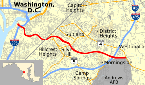
Suitland Parkway highlighted in red
|
|
| Route information | |
| Maintained by NPS | |
| Length | 9.1 mi (14.6 km) |
| Existed | 1944–present |
| Restrictions | No commercial vehicles east of Alabama Avenue |
| Major junctions | |
| West end | |
| East end | |
| Highway system | |
| 'Numbered highways in Washington, D.C.'Maryland highway system Interstate • US • State • Minor • Former • Turnpikes |
|
|
Suitland Parkway
|
|
| Nearest city | Suitland, Maryland |
| Area | 418.9 acres (169.5 ha) |
| Built | 1944 |
| MPS | Parkways of the National Capital Region MPS |
| NRHP reference No. | 95000604 |
| Added to NRHP | June 2, 1995 |
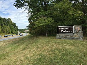
The Suitland Parkway is a special road in Washington, D.C. and Prince George's County, Maryland. It's managed by the U.S. National Park Service. This means it's cared for like a park, even though it's a road.
The parkway has some controlled access. This means you can't just turn onto it from any street. It uses a mix of interchanges (like highway exits) and regular intersections with traffic lights. People who own land next to the parkway cannot build driveways directly onto it.
Contents
About the Suitland Parkway
The Suitland Parkway is about 9.35 miles (15.05 km) long. It stretches from Washington, D.C. to Forestville, Maryland. Its western end is near Interstate 295. This is close to the Frederick Douglass Memorial Bridge. The eastern end is at Pennsylvania Avenue (which is also Maryland Route 4). This spot is near Joint Base Andrews.
In 1995, the Suitland Parkway was added to the National Register of Historic Places. This list includes important historical sites in the United States. It's also part of the National Highway System. This system includes roads important for the country's economy and defense.
A Bit of History
The idea for the Suitland Parkway came about in 1937. It was built during World War II. Its main purpose was to connect military bases. These bases were located around the Washington, D.C. area.
The parkway fully opened on December 9, 1944. It was first called the Camp Springs Highway. This was because it linked Camp Springs (now Joint Base Andrews) with Bolling Air Force Base. One lane of the highway actually opened a bit earlier, in mid-October 1944.
At first, the eastern part of the parkway had only two lanes. The western part had four lanes. In the 1990s, the eastern part was made wider. It was doubled in size to match the western part. This work was finished in 1996. Around the same time, a 2-mile-long bike trail was built. It's called the Suitland Parkway Trail.
What is a Parkway?
A parkway is a special type of road. It's often designed to be scenic and pleasant to drive on. Parkways usually have green spaces along their sides. They often connect parks or other important areas. They are usually managed by park services, not regular highway departments.
Traveling the Parkway
The Suitland Parkway starts in Washington, D.C.. It begins at an interchange with I-295. It heads southeast as a four-lane road with a divider in the middle. It passes near homes and curves south.
After a short distance, the parkway reaches Southern Avenue SE. Here, the Suitland Parkway crosses into Prince George's County in Maryland.
In Maryland, the road goes northeast into Temple Hills. It has a traffic light with MD 637. Then it comes to an interchange with MD 5. The parkway continues east, passing under the Green Line of the Washington Metro subway.
Further along, the parkway reaches Suitland. Here, it has an interchange with MD 458. The road continues through wooded areas. It passes near the town of Morningside.
The parkway then comes to a traffic light with MD 337. It passes under I-95/I-495 without an exit. After this, it passes north of Joint Base Andrews. There's an interchange that lets you get to the north gate of the base.
Finally, the Suitland Parkway ends at a traffic light with MD 4 in Forestville.
Rules for Vehicles
In the Washington, D.C. part of the parkway, large commercial vehicles like trucks are allowed. However, these trucks must exit the parkway at Alabama Avenue. They are not allowed to continue further east into Maryland on the parkway.
 | Percy Lavon Julian |
 | Katherine Johnson |
 | George Washington Carver |
 | Annie Easley |


