
Suitland, Maryland facts for kids
Quick facts for kids
Suitland, Maryland
|
|
|---|---|

The headquarters of the United States Census Bureau in March 2007
|
|

Suitland, Maryland
Location in Maryland

Suitland, Maryland
Location in the United States
|
|
| Country | |
| State | |
| County | |
| Area | |
| • Total | 4.25 sq mi (11.01 km2) |
| • Land | 4.25 sq mi (11.00 km2) |
| • Water | 0.00 sq mi (0.01 km2) |
| Elevation | 290 ft (90 m) |
| Population
(2020)
|
|
| • Total | 25,839 |
| • Density | 6,085.49/sq mi (2,349.49/km2) |
| Time zone | UTC−5 (Eastern (EST)) |
| • Summer (DST) | UTC−4 (EDT) |
| ZIP Codes |
20746, 20747
|
| Area code(s) | 301, 240 |
| FIPS code | 24-75725 |
Suitland is a community located in Maryland, very close to Washington, D.C.. It is about one mile (1.6 km) southeast of the nation's capital. Suitland is known as a census-designated place (CDP). This means it is an area identified by the U.S. Census Bureau for statistical purposes. In 2020, about 25,839 people lived there. Before 2010, Suitland was part of a larger census area called Suitland-Silver Hill.
Contents
- Exploring Suitland's Past
- Suitland's Location and Natural Areas
- Who Lives in Suitland?
- Getting Around Suitland
- Education in Suitland
- What Agencies are in Suitland?
- Famous People from Suitland
- Images for kids
- See also
Exploring Suitland's Past
Suitland got its name from a man named Senator Samuel Taylor Suit. He was a businessman and landowner in the 1800s. His large estate, also called "Suitland," was near where Suitland and Silver Hill Roads are today.
Early Days: 1600s and 1700s
Long ago, in the 1600s, the Piscataway tribe lived in southern Maryland. European settlers arrived in 1634. They slowly moved into what is now Prince George's County. The Piscataways moved north in 1697. They eventually settled in Pennsylvania and Michigan.
The main product grown by European settlers was tobacco. This crop made Prince George's County very rich.
The 1800s: Changes and Growth
Before the American Civil War, tobacco farming made Prince George's County one of Maryland's wealthiest areas. After the war, large farms were divided. New communities grew, focused on small farms and villages.
In 1867, Samuel Taylor Suit bought over 800 acres (320 hectares) near Washington, D.C. Important guests, like U.S. Presidents Ulysses S. Grant and Rutherford B. Hayes, visited his estate. After Suit passed away in 1888, parts of his land were sold. His son, Arthur B. Suit, kept 3 acres (1.2 hectares). He ran a general store, a bar, and a bowling alley there. He even had the community's small jailhouse.
The 1900s: Modernizing Suitland
By the early 1900s, Suitland had a post office, churches, and more homes. In 1909, residents formed the Suitland Improvement Association. They wanted to raise money for a community hall. This group is now called the Suitland Civic Association.
Historic Cemeteries in Suitland
Suitland has two old cemeteries: Cedar Hill and Lincoln Memorial. Cedar Hill Cemetery started in 1901. It was built on a former plantation. It is the burial site for people who died in a train wreck in 1906.
Lincoln Memorial Cemetery opened in 1927. Many famous African Americans are buried there. These include Dr. Charles Richard Drew, who improved blood storage. Also, Nannie Helen Burroughs, an educator and civil rights activist, is buried there.
Schools and Airfields
The first one-room schoolhouse in Suitland was built in 1891. A larger two-room school was built in 1915. It grew over the years with more additions.
From 1938 to 1941, a small airfield called "Skyhaven" operated in Suitland. It was named by a local student. This airfield was home to a flying club with about 20 small planes.
World War II and the Federal Center
Suitland was mostly a farming community until World War II. The war created a need for more office space for the government. In 1941, the government bought 437 acres (177 hectares) in Suitland. They built the Suitland Federal Center there. This center was for federal offices.
The Suitland House, a historic home, is still on the Federal Center property. It is now used as office space by the U.S. Census Bureau.
Housing and Gardens
In 1942, the Suitland Manor apartments were built. They were for the new federal workers coming to the area. Other housing developments followed. In 1943, the Census Bureau created a large "Victory Garden" at the Federal Center. Employees grew food there to help with the war effort.
Suitland Parkway and Schools
The Suitland Parkway opened in 1944. It connected military bases. It was first only for military use. Later, it became a public road.
Suitland Junior-Senior High School was the first high school in Suitland. It opened in 1951. There was also LaReine High School, a Catholic school for girls. It later closed, and its students went to Bishop McNamara High School.
Growth and Changes in the Late 1900s
The 1950s and 1960s saw Suitland grow a lot. Many new families moved into the area. This growth slowed down around 1970. This was due to factors like cheaper land elsewhere and changes in population.
In the 1970s, Prince George's County began busing students for desegregation. This changed the neighborhoods. Many middle-class areas became more diverse.
Local historians began to record Suitland's history. In 1975, a book called A History of Suitland, Maryland, 1867-1976 was written. Also, the Suitland Bog, a special wetland, was saved.
In the 1980s, efforts were made to improve safety around the Federal Center. By the mid-1990s, plans were made to make Suitland better. This included improving housing and reducing crime.
The 2000s: Revitalization and Development

The Suitland Metro station opened in 2001. This made it easier for people to travel to and from Suitland.
New housing projects, like Windsor Crossing, were built in 2004. A new Suitland Elementary School opened in 2005. Major renovations were also done at the U.S. Census Building.
In 2009, Andrews Air Force Base became Joint Base Andrews. This brought more jobs to the area. The Spauldings Branch Library was also renovated in 2012.
Recent efforts have focused on improving Suitland. Crime rates have fallen. New projects like "Buy Suitland" help people buy homes. The Green Suitland Neighborhood Stabilization Project helps fix up old homes.
Suitland's Location and Natural Areas
Suitland is an unincorporated area. This means its exact borders are not officially set. It is generally bordered by Southern Avenue to the north, Branch Avenue to the west, Pennsylvania Avenue to the east, and Henson Creek to the south.
Suitland has a total area of about 11.0 square kilometers (4.25 square miles). This is a bit smaller than what was used in previous years for census data.
The Suitland Bog
The Suitland Bog is a unique natural area. It is one of the last natural bogs in the Washington, D.C. region. Bogs are special wetlands. This bog has rare plants like sweet bay magnolias, northern pitcher-plants, and lady slipper orchids.
Parks and Recreation
Suitland has several parks and recreation centers. These are managed by the Prince George's County Department of Parks and Recreation. They include:
- Bradbury Heights Recreation Center
- William Beanes Community Center
- Auth Village Neighborhood Park
- Douglas Patterson Community Park
- Dupont Heights Neighborhood Park
- Michael J. Polley Neighborhood Park
Who Lives in Suitland?
| Historical population | |||
|---|---|---|---|
| Census | Pop. | %± | |
| 1960 | 10,300 | — | |
| 1970 | 30,355 | 194.7% | |
| 1980 | 32,164 | 6.0% | |
| 1990 | 35,111 | 9.2% | |
| 2000 | 33,515 | −4.5% | |
| 2010 | 25,825 | −22.9% | |
| 2020 | 25,839 | 0.1% | |
| U.S. Decennial Census 2010 2020 Note: land area of Suitland CDP reduced by 25% for 2010 census |
|||
The population of Suitland was 25,839 people in 2020. The area is quite dense, with many people living per square mile.
Population Details from 2020
| Race / Ethnicity | Pop 2010 | Pop 2020 | % 2010 | % 2020 |
|---|---|---|---|---|
| White alone (NH) | 450 | 489 | 1.74% | 1.89% |
| Black or African American alone (NH) | 23,569 | 22,424 | 91.26% | 86.78% |
| Native American or Alaska Native alone (NH) | 78 | 32 | 0.30% | 0.12% |
| Asian alone (NH) | 88 | 166 | 0.34% | 0.64% |
| Pacific Islander alone (NH) | 6 | 1 | 0.02% | 0.00% |
| Some Other Race alone (NH) | 23 | 87 | 0.09% | 0.34% |
| Mixed Race/Multi-Racial (NH) | 387 | 615 | 1.50% | 2.38% |
| Hispanic or Latino (any race) | 1,224 | 2,025 | 4.74% | 7.84% |
| Total | 25,825 | 25,839 | 100.00% | 100.00% |
Note: The U.S. Census counts Hispanic/Latino as an ethnic group. This table separates them from racial categories.
In 2020, most people in Suitland were Black or African American (86.78%). About 7.84% of the population was Hispanic or Latino.
What the 2010 Census Showed
In 2010, Suitland had 25,825 people and 10,139 households. The population density was about 6,148 people per square mile. Most residents (91.9%) were African American.
The average household size was 2.53 people. The average family size was 3.19 people. About 23.9% of the population was under 18 years old. The median age was 30.5 years. The median household income was $56,217.
| Population by Race in Suitland Maryland (2010) | ||
| Race | Population | % of Total |
|---|---|---|
| Total | 25,825 | 100 |
| African American | 23,746 | 91 |
| Hispanic | 1,224 | 4 |
| Other | 671 | 2 |
| Caucasian | 663 | 2 |
| Two or More Races | 540 | 2 |
| American Indian | 104 | < 1% |
Getting Around Suitland
Suitland has several main roads. Suitland Parkway runs through the entire area. You can also get to the Capital Beltway from Pennsylvania Avenue (MD 4) and Branch Avenue (MD 5).
The community is also served by the Washington Metro system. The Naylor Road, Suitland, and Branch Avenue stations are all on the Green Line.
Important Roads and Highways
 Interstate 95: This major highway goes through Prince George's County. It connects with Interstate 495 (Capital Beltway).
 Interstate 495 (Capital Beltway): Also known as the Capital Beltway, this highway circles Washington, D.C.
 Maryland Route 4 (Pennsylvania Avenue): Runs from the D.C. border eastward.
 Maryland Route 5 (Branch Avenue): Runs from the D.C. border southeast.
 Maryland Route 458 (Silver Hill Road): Connects Branch Avenue to Walker Mill Road.
 Maryland Route 218 (Suitland Road): Runs from the D.C. border to Joint Base Andrews.
Education in Suitland
Suitland is part of the Prince George's County Public Schools system. This system serves the entire county.
Schools for Younger Students
Several elementary schools serve different parts of Suitland. These include:
- Suitland Elementary
- William Beanes Elementary
- Samuel P. Massie Academy
- Andrew Jackson Academy
- Francis Scott Key Elementary
- Bradbury Heights Elementary
Most middle school students go to Drew-Freeman Middle School. Some attend Samuel Massie Academy and Andrew Jackson Academy, which became K-8 schools in 2009.
Suitland High School
All high school students in Suitland attend Suitland High School. It is a public magnet school. It offers special programs in:
- Visual and performing arts
- International Baccalaureate program
- Vocational Technical Academy
In the past, there was an all-girls Catholic high school called La Reine High School. It closed in 1992. Its students then went to Bishop McNamara High School.
Public Libraries
The Spauldings Branch Library serves Suitland. It is part of the Prince George's County Memorial Library System. The library was fully renovated in 2012.
What Agencies are in Suitland?

The federal government has many important offices in the Suitland Federal Center. These include:
- United States Census Bureau: This agency collects information about the U.S. population.
- National Archives and Records Administration, Washington National Records Center: This center stores important government records.
- Office of Naval Intelligence: This group gathers information for the U.S. Navy.
- National Maritime Intelligence-Integration Office: This office works on maritime intelligence.
- NOAA Office of Satellite Operations: This office manages weather and environmental satellites.
- Smithsonian Institution, Museum Support Center: This center stores and cares for museum collections.
- Smithsonian Institution, National Museum of the American Indian Cultural Resources Center: This center supports the National Museum of the American Indian.
- Smithsonian Institution, Paul E. Garber Preservation and Storage Facility: This facility preserves and stores aircraft and space artifacts.
- Bureau of Economic Analysis: This agency provides important economic statistics.
Famous People from Suitland
Many notable people have connections to Suitland, including:
- Angela Alsobrooks (b. 1971) – A lawyer and politician.
- Reginald Dwayne Betts (b. 1980) – A poet and writer.
- NaVorro Bowman (b. 1988) – A professional football player.
- Kevin Durant (b. 1988) – A famous NBA basketball player.
- George O. Gore II (b. 1982) – An actor.
- Steny Hoyer (b. 1939) – A leader in the U.S. House of Representatives.
- LaMont Jordan (b. 1978) – A professional football player.
- Chad Scott (b. 1974) – A professional football player.
- Devin Tyler (b. 1986) – A professional football player.
- Jude Waddy (b. 1975) – A professional football player.
- Cordae (b. 1997) – A popular rapper.
Images for kids
-
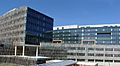
The headquarters of the United States Census Bureau in March 2007
-
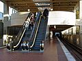
The Suitland Metro station in October 2006.
-
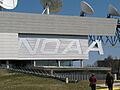
National Oceanic and Atmospheric Administration satellite control facility at Suitland
See also
 In Spanish: Suitland para niños
