Gordon, Ohio facts for kids
Quick facts for kids
Gordon, Ohio
|
|
|---|---|
|
Village
|
|

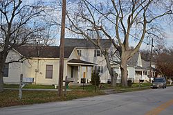
North Street west of Main Street
|
|

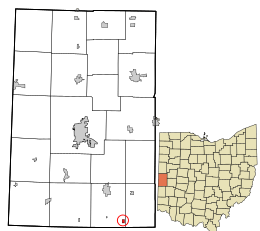
Location in Darke County and the state of Ohio.
|
|
| Country | United States |
| State | Ohio |
| County | Darke |
| Township | Twin |
| Area | |
| • Total | 0.17 sq mi (0.43 km2) |
| • Land | 0.17 sq mi (0.43 km2) |
| • Water | 0.00 sq mi (0.00 km2) |
| Elevation | 1,047 ft (319 m) |
| Population
(2020)
|
|
| • Total | 245 |
| • Estimate
(2023)
|
238 |
| • Density | 1,484.85/sq mi (574.81/km2) |
| Time zone | UTC-5 (Eastern (EST)) |
| • Summer (DST) | UTC-4 (EDT) |
| ZIP code |
45304
|
| Area code(s) | 937, 326 |
| FIPS code | 39-30912 |
| GNIS feature ID | 2398179 |
Gordon is a small village located in Darke County, Ohio, United States. It is a quiet community in the western part of the state. In 2020, about 245 people lived in Gordon.
Contents
History of Gordon
Gordon was first planned out in 1849. It was named after one of the first people who settled there. The village grew up around an important meeting point. This point was where the Dayton and Union and Ohio Electric railroads crossed paths. Railroads were very important for travel and trade back then.
Geography of Gordon
Gordon is a very small village. According to the United States Census Bureau, its total area is only about 0.17 square miles. That's about 0.43 square kilometers. All of this area is land, meaning there are no large lakes or rivers within the village limits.
Population and People in Gordon
| Historical population | |||
|---|---|---|---|
| Census | Pop. | %± | |
| 1870 | 87 | — | |
| 1900 | 177 | — | |
| 1910 | 181 | 2.3% | |
| 1920 | 153 | −15.5% | |
| 1930 | 137 | −10.5% | |
| 1940 | 178 | 29.9% | |
| 1950 | 197 | 10.7% | |
| 1960 | 265 | 34.5% | |
| 1970 | 232 | −12.5% | |
| 1980 | 230 | −0.9% | |
| 1990 | 206 | −10.4% | |
| 2000 | 190 | −7.8% | |
| 2010 | 212 | 11.6% | |
| 2020 | 245 | 15.6% | |
| 2023 (est.) | 238 | 12.3% | |
| U.S. Decennial Census | |||
Gordon's Population in 2010
In 2010, the census showed that 212 people lived in Gordon. There were 74 households, which are like homes or families living together. Out of these, 59 were families. The village had a population density of about 1,247 people per square mile. This means a lot of people lived in a small area.
Most of the people living in Gordon were White, making up 97.6% of the population. A small number of residents were African American or Native American. Some people also identified as being from other backgrounds or a mix of two or more races.
Households and Families
About 32.4% of the households in Gordon had children under 18 living with them. Most households (63.5%) were married couples living together. Some households were led by a single parent. About 18.9% of all households were made up of just one person. The average household had about 2.86 people. The average family size was about 3.24 people.
Age of Residents
The average age of people in Gordon in 2010 was 40.8 years old. About 25% of the residents were under 18 years old. This means a quarter of the village's population were kids or teenagers. About 13.7% of the people were 65 years old or older. This shows a mix of different age groups living in the village. There were slightly more males (53.3%) than females (46.7%) in Gordon.
See also
 In Spanish: Gordon (Ohio) para niños
 | Madam C. J. Walker |
 | Janet Emerson Bashen |
 | Annie Turnbo Malone |
 | Maggie L. Walker |

