
Graciosa, Canary Islands facts for kids

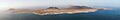
La Graciosa from Mirador Del Río
|
|
_-_OSM_Mapnik.svg)
La Graciosa
Location in Lanzarote

La Graciosa
Location in Province of Las Palmas

La Graciosa
Location in Canary Islands

La Graciosa
Location in Spain, Canary Islands
|
|
| Geography | |
|---|---|
| Location | Atlantic Ocean |
| Coordinates | 29°15′00″N 13°30′29″W / 29.250°N 13.508°W |
| Archipelago | Chinijo Archipelago, Canary Islands |
| Area | 29.05 km2 (11.22 sq mi) |
| Coastline | 30.395 km (18.8866 mi) |
| Highest elevation | 266 m (873 ft) |
| Highest point | Agujas Grandes |
| Administration | |
| Autonomous Community | |
| Province | Las Palmas |
| Municipality | Teguise |
| Largest settlement | Caleta de Sebo (pop. 730) |
| Demographics | |
| Population | 734 (2018) |
| Pop. density | 25.27 /km2 (65.45 /sq mi) |
| Languages | Spanish, specifically Canarian Spanish |
| Additional information | |
| Time zone |
|
| • Summer (DST) | |
La Graciosa is a small, beautiful volcanic island in the Canary Islands of Spain. Its name means "graceful" in Spanish. It is located just 2 kilometers (about 1.2 miles) north of Lanzarote island.
La Graciosa was formed by a "hotspot," which is a place deep in the Earth where hot rock rises to the surface. This created the volcanoes that built the island. It is part of a group of islands called the Chinijo Archipelago. This area is also a protected nature park.
For a long time, La Graciosa was considered a small islet. It was managed by the nearby island of Lanzarote. But in 2018, it officially became the eighth Canary Island. The main village on the island is Caleta de Sebo. There is also a small summer village called Casas de Pedro Barba.
Contents
Life on La Graciosa
About 700 people live on La Graciosa. The main ways people make a living here are through tourism and fishing. Many visitors come each year to enjoy the island's mild weather and sandy beaches.
Daily Life and Services
The island has a few important services for its residents and visitors. You can find a school, a post office, and some supermarkets. There is also a medical center and a pharmacy. The main village, Caleta de Sebo, has a port, beaches, and places to eat.
Because everything has to be brought in by boat, everyday items can be more expensive here.
Getting Around the Island
The streets and roads on La Graciosa are not paved. They are mostly made of sand. This means that regular cars are not allowed. Only a few special vehicles are permitted for specific jobs.
To get to the island, you can take a ferry. The ride from Órzola on Lanzarote to La Graciosa's harbor takes about 25 minutes. If you want to camp, there is a campsite on Playa del Salado, near Caleta de Sebo.
Exploring La Graciosa's Nature
La Graciosa is a very dry island. It is covered mostly with bushes and dry soil. It is about 8 kilometers (5 miles) long and 4 kilometers (2.5 miles) wide. The total area is about 29 square kilometers (11 square miles).
Water Supply
There are no natural sources of fresh water on the island. Since 2001, drinking water has been brought in through a pipe from Lanzarote. This water is desalinated, meaning salt is removed from seawater to make it drinkable. If the pipe breaks, the island's water supply can be at risk.
Hills and Beaches
La Graciosa has several hills. The tallest one is called Agujas Grandes, which is 266 meters (873 feet) high. The second tallest is Agujas Chicas, at 228 meters (748 feet).
The island is also known for its beautiful beaches. One popular spot is Playa de la Cocina, located in the southwestern part of the island.
Images for kids
-
Panorama photo taken from Lanzarote showing La Graciosa
See also
 In Spanish: La Graciosa para niños
