
Graft-De Rijp facts for kids
Quick facts for kids
Graft-De Rijp
|
|||
|---|---|---|---|
|
Former municipality
|
|||

Traditional houses in De Rijp
|
|||
|
|||
.svg)
Location in North Holland
|
|||
| Country | Netherlands | ||
| Province | North Holland | ||
| Municipality | Alkmaar | ||
| Established | 1 August 1970 | ||
| Area | |||
| • Total | 21.76 km2 (8.40 sq mi) | ||
| • Land | 20.03 km2 (7.73 sq mi) | ||
| • Water | 1.73 km2 (0.67 sq mi) | ||
| Elevation | −2 m (−6.6 ft) | ||
| Population
(May 2014)
|
|||
| • Total | 6,410 | ||
| • Density | 320/km2 (800/sq mi) | ||
| Time zone | UTC+1 (CET) | ||
| • Summer (DST) | UTC+2 (CEST) | ||
| Postcode |
1483–1488, 1536
|
||
| Area code | 0299 | ||


Graft-De Rijp (Dutch pronunciation: [ˌɣrɑvdəˈrɛip]) was once a small local government area, called a municipality, in the Netherlands. It was located in the province of North Holland. Since January 2015, Graft-De Rijp has become part of a larger municipality named Alkmaar.
Graft-De Rijp also had a special friendship with a place in England called Chalfont St Giles. This kind of friendship is called town twinning. It helps different towns learn about each other's cultures.
Towns and Villages of Graft-De Rijp
The former municipality of Graft-De Rijp was made up of several smaller towns and villages. These places were all part of the same local government area.
Here are the towns and villages that were once part of Graft-De Rijp:
- De Rijp
- Graft
- Markenbinnen
- Noordeinde
- Oost-Graftdijk
- Starnmeer
- West-Graftdijk
-
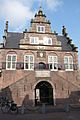
This building used to be a weigh house and the Town hall in De Rijp. It was designed by Jan Leeghwater in 1630.
-
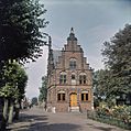
This is the Town Hall of Graft. It was built in 1613 in a style similar to the famous architect Hendrick de Keyser.


