
North Holland facts for kids
Quick facts for kids
North Holland
Noord-Holland
|
|||
|---|---|---|---|
|
|||
| Anthem: "Noord-Hollands Volkslied" (Anthem of North Holland) |
|||

Location of North Holland in the Netherlands
|
|||
| Country | Netherlands | ||
| Established | 1840 (split-up of Holland) | ||
| Capital | Haarlem | ||
| Largest city | Amsterdam | ||
| Area | |||
| • Total | 2,670 km2 (1,030 sq mi) | ||
| • Water | 1,421 km2 (549 sq mi) | ||
| Area rank | 6th nationally | ||
| Population
(1 January 2015)
|
|||
| • Total | 2,762,163 | ||
| • Rank | 2nd nationally | ||
| • Density | 1,034.5/km2 (2,679/sq mi) | ||
| • Density rank | 2nd nationally | ||
| Time zone | UTC+1 (CET) | ||
| • Summer (DST) | UTC+2 (CEST) | ||
| ISO 3166 code | NL-NH | ||
| GDP (nominal) | 2017 | ||
| - Total | €159 billion/ USD 200 billion | ||
| - Per capita | €56,300/ USD 70,000 | ||
| HDI (2017) | 0.946 very high · 2nd |
||


North Holland (called Noard-Holland in West Frisian Dutch) is a province in the northwest of the Netherlands. It sits along the North Sea coast. In 2015, about 2.7 million people lived there. The province covers an area of about 2,670 square kilometers (1,030 sq mi).
For many centuries, this area was part of a larger region called the County of Holland. In 1840, the province of Holland was split into two new provinces: North Holland and South Holland. Later, in 1855, a large lake called the Haarlemmermeer was drained. This turned the lake into land, which became part of North Holland.
The capital city of North Holland is Haarlem. However, the largest city in the province, and also the capital of the entire Netherlands, is Amsterdam. The main leader of North Holland is called the King's Commissioner. As of 2010, this role has been held by Arthur van Dijk. North Holland has 47 local areas called municipalities.
Contents
History of North Holland
How North Holland Became a Province (1795-1840)
The way North Holland looks today started during the time when France ruled the Netherlands, from 1795 to 1813. During this period, the Dutch provinces changed a lot. In 1795, the old system was replaced by the Batavian Republic.
In 1798, the country was divided into eight new areas called "departments." The old region of Holland was split into five of these. This was a big change, as it broke up the powerful Holland region.
In 1807, Holland was reorganized again into two departments: "Amstelland" (which is similar to today's North Holland) and "Maasland" (like today's South Holland). This also didn't last long. By 1810, all Dutch provinces became part of the French Empire.
After the French were defeated in 1813, the old province of Holland was put back together in 1814. However, it was still treated like two separate areas. It had two governors, one for the northern part (Amstelland) and one for the southern part (Maasland). This showed that the idea of splitting Holland was still around.
Finally, in 1840, Holland was officially split into "North Holland" and "South Holland." This change was mainly pushed by the city of Amsterdam. Amsterdam was not happy that the main court of appeal had moved to The Hague in South Holland.
Growth and Changes (1840 to Today)

After the Haarlemmermeer lake was drained in 1855, the new land became part of North Holland. In return, South Holland received a small part of another municipality. Over the years, some islands and former islands moved between provinces. For example, the islands of Vlieland and Terschelling became part of Friesland in 1942.
In 2011, North Holland, along with the provinces of Utrecht and Flevoland, started looking into joining together. This idea was supported by the Dutch government. The goal was to create one very large province in the Randstad area, which is a major urban region in the Netherlands. If this new province were created, it would be the largest in the Netherlands in both size and population.
Geography and Landscape


North Holland is located at 52°40′N 4°50′E / 52.667°N 4.833°E in the northwest of the Netherlands. To its northeast is the province of Friesland. To the east is Flevoland, and to the southeast is Utrecht. To the southwest is South Holland, and to the west is the North Sea.
North Holland is mostly a wide piece of land surrounded by water. It lies between the North Sea, the Wadden Sea, the IJsselmeer, and the Markermeer. More than half of the province is made of polder land. This means it's land that was once underwater and has been reclaimed from the sea. Much of it is below sea level. The West Frisian islands of Noorderhaaks and Texel are also part of North Holland.
Local Areas: Municipalities
As of January 2019, North Holland is divided into 47 local areas called municipalities. These are like local governments.
North Holland has five municipalities with more than 100,000 people. These are, from largest to smallest:
- Amsterdam (which is also the largest municipality in the entire Netherlands)
- Haarlem
- Zaanstad
- Haarlemmermeer
- Alkmaar
Another seven municipalities have between 50,000 and 100,000 people. These include Hilversum, Amstelveen, Purmerend, Hoorn, Velsen, Den Helder, and Heerhugowaard.
On January 1, 2015, two smaller municipalities, Graft-De Rijp and Schermer, joined with the municipality of Alkmaar. On January 1, 2019, Haarlemmerliede en Spaarnwoude joined with Haarlemmermeer.
Different Regions in North Holland

North Holland has many different regions. These areas have their own unique identities, often because of their history. Some of these regions are unofficial, while others are used for administrative purposes. These regions are not the same as the municipalities.
Here are some of the well-known regions in North Holland:
- Amstelland (the area around the Amstel river)
- Beemster (a famous polder area)
- Bollenstreek (flower bulb region, also in South Holland)
- Het Gooi (a wealthy area with many forests)
- Haarlemmermeer (the polder that used to be a lake)
- IJmond ("The Mouth of the IJ" river)
- Kennemerland (a coastal region)
- Kop van Noord-Holland (the northern tip of North Holland)
- Randstad (a very large urban area that includes parts of North Holland, South Holland, Utrecht, and Flevoland)
- Texel (an island)
- Waterland (a wet, green area with many small villages)
- West-Friesland (a historical region with its own culture)
- Zaanstreek ("The Zaan Area," known for its windmills)
Nature and Parks

North Holland is home to some beautiful nature reserves. These places protect important plants and animals. Some of the most famous ones include:
- Wadden Sea: A large area of mudflats and wetlands, important for birds.
- Zuid-Kennemerland National Park: A national park with dunes, forests, and beaches.
- Dunes of Texel National Park: A national park on the island of Texel, known for its unique dune landscapes.
Images for kids
-
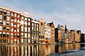
Damrak in Amsterdam
-
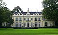
Hartekamp in Heemstede
-
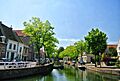
The inner city of Hoorn
-
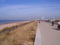
The boulevard in Zandvoort
-
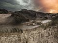
National Park Duinen van Texel
-
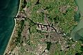
Satellite image of the south of North Holland
-
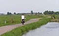
A typical scene in Waterland
.jpg)

.jpg)


.jpg)


See also
 In Spanish: Provincia de Holanda Septentrional para niños
