
Texel facts for kids
Quick facts for kids
Texel
|
|||
|---|---|---|---|
|
Municipality and island
|
|||

North end of the island with the Eierland Lighthouse in 2015
|
|||
|
|||
.svg)
Location in North Holland
|
|||
| Country | Netherlands | ||
| Province | North Holland | ||
| Government | |||
| • Body | Municipal council | ||
| Area | |||
| • Total | 463.16 km2 (178.83 sq mi) | ||
| • Land | 161.12 km2 (62.21 sq mi) | ||
| • Water | 302.04 km2 (116.62 sq mi) | ||
| Elevation | 2 m (7 ft) | ||
| Population
(May 2014)
|
|||
| • Total | 13,641 | ||
| • Density | 85/km2 (220/sq mi) | ||
| Demonym(s) | Tesselaar, Texelaar | ||
| Time zone | UTC+1 (CET) | ||
| • Summer (DST) | UTC+2 (CEST) | ||
| Postcode |
1790–1797
|
||
| Area code | 0222 | ||


Texel (pronounced Tessel) is a special island in the Netherlands. It's also a municipality (like a local government area). About 13,643 people live here. Texel is the biggest and most populated island in the West Frisian Islands. These islands are found in the Wadden Sea. You can find Texel north of Den Helder and southwest of Vlieland.
Contents
All About the Name Texel
The name Texel comes from the Frisian language. Even though it's spelled with an 'x', people in Dutch usually say "Tessel". This is because of old changes in the Dutch language. In Dutch, the 'x' sound often changed to an 's' sound over time. For example, the English word fox is vos in Dutch.
Texel's Exciting History
Texel has a long and interesting past!
How Texel Became an Island
In 1170, a huge flood called the All Saints' Flood (1170) happened. This flood helped create the islands of Texel and Wieringen. Before that, they were connected to North Holland. In the 1200s, a noblewoman named Ada was even held prisoner on Texel!
Texel's City Rights
Texel was given "city rights" in 1415. This meant it had special rules and freedoms, similar to a city, even though it was an island.
Important Sea Battles and Voyages
Many important events at sea happened near Texel.
- In 1594, the first Dutch journey to find the Northwest Passage started from Texel. This was a sea route people hoped would connect Europe to Asia through the Arctic.
- Texel was part of big sea fights like the Battle of Scheveningen in 1653 and the Battle of Texel in 1673. These battles were part of wars between the English and the Dutch.
(Ludolf_Backhuysen,_1671).jpg)

- During the American Revolution in 1779, a famous American sailor named John Paul Jones brought his damaged ship to Texel for repairs after a big battle. This caused some problems between the British and the Dutch.
- In 1797, Texel was involved in the Battle of Camperdown during the French Revolutionary Wars.
- In 1914, during the First World War, a naval battle called the Battle off Texel took place off the island's coast.
- In 1940, during the Second World War, two British ships sank near Texel because of German mines. This sad event is known as the Texel Disaster.
The Georgian Uprising
Near the end of the Second World War in 1945, something very unusual happened on Texel. Soldiers from Georgia (a country in Europe) were fighting for Germany. When the Germans decided to move them, the Georgian soldiers revolted! They fought against their German comrades. This uprising lasted from April 5 to May 20, 1945. Canadian troops arrived and helped end the fighting. Because it happened after the official end of the war in Europe (V-E Day), it's sometimes called the last battle of the Second World War in Europe. Many Georgian soldiers who died are buried in a special cemetery on Texel, often called the "Russian cemetery."
Exploring Texel's Geography
Texel is located north of the mainland province of North Holland. It's west of the mainland province of Friesland. The island is north of Den Helder and southwest of Vlieland.
How Texel Was Formed
The island of Texel wasn't always one piece. It used to be two separate islands: Texel (in the south) and Eierland (in the northeast). These two islands were connected by shallow areas of sand called shoals. In the early 1600s, a long wall called a dyke was built. This dyke connected the two islands and protected the coast from the North Sea. Later, in the mid-1800s, a polder (land reclaimed from the sea) finished connecting the northern part of the island. Today, Texel acts as a big natural wall between the North Sea and the Wadden Sea.
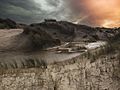
Texel's Landscape and Nature
Texel is about 23.7 kilometers long and 9.6 kilometers wide. Its total area is 162 square kilometers. The highest point on the island is a sand dune called "Bertusnol," which is 19.6 meters high. This dune is part of the Dunes of Texel National Park.

The sandy dune areas on Texel are very important for wildlife. A special place is De Slufter. Here, the ocean tide comes in and meets the dunes, creating a marshy area. This marsh is full of different animals and plants. In winter, you can see many birds of prey and geese here. About one-third of Texel is a protected nature reserve. There's also a wetland called Utopia, designed especially for birds to build their nests.
Texel's Climate
Texel has an oceanic climate. This means its weather is strongly affected by being surrounded by the sea. The temperature usually ranges from about 5°C (41°F) in winter to 21°C (70°F) in summer. While winters are similar to the mainland, summers are usually cooler. However, Texel can still get very hot days, with temperatures sometimes going above 30°C (86°F) in five different months. The island gets a fair amount of rain, spread out evenly through most of the year. It's usually a bit drier in late spring and rainier in autumn.
| Climate data for Texel | |||||||||||||
|---|---|---|---|---|---|---|---|---|---|---|---|---|---|
| Month | Jan | Feb | Mar | Apr | May | Jun | Jul | Aug | Sep | Oct | Nov | Dec | Year |
| Record high °C (°F) | 13.7 (56.7) |
14.9 (58.8) |
20.5 (68.9) |
27.9 (82.2) |
31.0 (87.8) |
31.7 (89.1) |
34.6 (94.3) |
33.8 (92.8) |
32.6 (90.7) |
24.8 (76.6) |
17.7 (63.9) |
15.3 (59.5) |
34.6 (94.3) |
| Mean daily maximum °C (°F) | 5.5 (41.9) |
5.5 (41.9) |
8.3 (46.9) |
11.7 (53.1) |
15.4 (59.7) |
18 (64) |
20.3 (68.5) |
20.6 (69.1) |
17.9 (64.2) |
14 (57) |
9.7 (49.5) |
6.4 (43.5) |
12.8 (54.9) |
| Mean daily minimum °C (°F) | 1.2 (34.2) |
0.8 (33.4) |
2.8 (37.0) |
5 (41) |
8.6 (47.5) |
11.3 (52.3) |
13.8 (56.8) |
14 (57) |
11.7 (53.1) |
8.5 (47.3) |
4.9 (40.8) |
2 (36) |
7.1 (44.7) |
| Record low °C (°F) | −18.8 (−1.8) |
−18.5 (−1.3) |
−14.5 (5.9) |
−4.8 (23.4) |
−2.1 (28.2) |
1.5 (34.7) |
5.2 (41.4) |
5.6 (42.1) |
3.0 (37.4) |
−4.6 (23.7) |
−10.8 (12.6) |
−12.3 (9.9) |
−18.8 (−1.8) |
| Average precipitation mm (inches) | 66.2 (2.61) |
44.4 (1.75) |
52.4 (2.06) |
33.7 (1.33) |
45 (1.8) |
54.1 (2.13) |
59.8 (2.35) |
76.8 (3.02) |
83.7 (3.30) |
95.9 (3.78) |
83.5 (3.29) |
69.8 (2.75) |
765.3 (30.17) |
| Mean monthly sunshine hours | 64.1 | 91.1 | 134.8 | 194.2 | 235.2 | 219 | 228.2 | 208.2 | 148 | 114.2 | 63.1 | 51 | 1,751.1 |
Famous People from Texel
Many interesting people have come from Texel!


- Willem Eduard Bok (1846–1904): A politician and civil servant in South Africa.
- Rene Daalder (1944–2019): A Dutch writer and director.
- Cornelis de Jager (1921–2021): An astronomer who studied the sun.
- Imme Dros (born 1936): A well-known Dutch writer of children's books.
- Hans Kamp (born 1940): A philosopher and linguist who created a theory about how we understand language.
- Willem Hendrik Keesom (1876–1956): A physicist who was the first to freeze liquid helium.
- Sim Visser (1908–1983): A Dutch politician.
- Henk Zijm (born 1952): A mathematician from the University of Twente.
Sports Stars from Texel
Texel has also produced some great athletes!
- Denise Betsema (born 1993): A professional cyclo-cross cyclist.
- Alice Blom (born 1980): A talented volleyball player.
- Dorian van Rijsselberghe (born 1988): A sailor who won gold medals at the 2012 and 2016 Summer Olympics.
Texel's Economy and Jobs
Tourism is a huge part of Texel's economy. About 70% of all activities on the island are linked to tourism. People love to visit Texel for cycling, walking, swimming, and horse riding.

Besides tourism, traditional jobs include farming (raising sheep, growing potatoes, dairy farming, tulips, and grain) and fishing. Most fishing boats operate from the town of Oudeschild.
Getting Around Texel
You can travel around Texel by bicycle, bus (called Texelhopper), or car. The island has many special paths just for bikes. To get to Texel from the mainland, you can take a ferry. The ferry company is called Royal TESO. The ferries leave from Den Helder. Texel also has its own airport, Texel International Airport. The ferry Texelstroom is special because it uses mostly natural gas, which is better for the environment.

Images for kids
-
De Hors at Dunes of Texel National Park

See also
 In Spanish: Texel para niños
