
Terschelling facts for kids
Quick facts for kids
Terschelling
Skylge
|
|||
|---|---|---|---|
|
Municipality and island
|
|||
|
Lighthouse
Museum West-Terschelling
Mill of Formerum
Emergency shelter for shipwreck victims
|
|||
|
|||

Location in Friesland
|
|||
| Country | Netherlands | ||
| Province | Friesland | ||
| Government | |||
| • Body | Municipal council | ||
| Area | |||
| • Total | 673.99 km2 (260.23 sq mi) | ||
| • Land | 86.16 km2 (33.27 sq mi) | ||
| • Water | 587.83 km2 (226.96 sq mi) | ||
| Elevation | 6 m (20 ft) | ||
| Population
(May 2014)
|
|||
| • Total | 4,721 | ||
| • Density | 55/km2 (140/sq mi) | ||
| Demonym(s) | Terschellinger | ||
| Time zone | UTC+1 (CET) | ||
| • Summer (DST) | UTC+2 (CEST) | ||
| Postcode |
8880–8897
|
||
| Area code | 0562 | ||
| Official name: Duinen Terschelling | |||
| Designated: | 29 August 2000 | ||
| Reference #: | 2215 | ||
.jpg)


Terschelling is a special island in the northern Netherlands. It is also a municipality. The island is one of the West Frisian Islands. You can find it between the islands of Vlieland and Ameland.
People who live on the Wadden Islands are very clever. They use things that wash up on shore. For example, they often build farms and barns from old ship masts. This is because there are not many trees on the island. Many old shipwrecks are found around the islands. Even today, containers sometimes wash ashore from large container ships in the North Sea.
Tourism is the main way people on Terschelling make money. There is some farming, but a big part of the island is a nature reserve. This means it is protected for plants and animals.
Terschelling is famous for the yearly Oerol Festival. During this festival, theater shows happen all over the island. The shows use the island's natural beauty as their stage.
You can get to Terschelling by ferry from the town of Harlingen on the mainland. In summer, you can also take a fast catamaran from Vlieland.
Contents
Island History and Formation
The island we see today was formed a long time ago in the Middle Ages. It started as a sandy area called De Schelling in the west. The eastern part was an older island named Wexalia. The name Wexalia was used until the end of the Middle Ages.
The oldest signs of people living on Terschelling are from around 850 AD. A small wooden church was built on a hill near a place called Stryp. This hill later became a burial ground. It is now known as the "Strieperkerkhof."
Long ago, there were disagreements between the people of West-Terschelling and East-Terschelling. West-Terschelling people focused on the sea. East-Terschelling people were more interested in farming. In 1612, the island was even split into two separate areas. They became one island again after the French took over in the early 1800s.
Famous People from Terschelling

A famous Dutch explorer, Willem Barentsz, was born on Terschelling around 1550. He was a navigator and made maps. He explored the Arctic, and the Barents Sea is named after him.
Major Events in Terschelling's Past
In 1666, the town of West-Terschelling was attacked by the English. The English fleet wanted to attack Dutch ships near Vlieland. When the Dutch ships moved towards Terschelling, the English followed. They destroyed many Dutch vessels. Then, they landed in West-Terschelling's harbor. The town was burned down by the English. This event is known as "Holmes' Bonfire". It was named after the English admiral, Sir Robert Holmes.
The next year, in 1667, the Dutch fought back. They attacked the English navy in a big way. This battle was called the Raid on the Medway. It helped end the Second Anglo-Dutch War.
In 1799, a British ship called HMS Lutine sank off the coast of Terschelling. It was carrying a lot of British gold. The ship's wreck moved around in the sand. People searched for the treasure many times, but only a few pieces were found. A special cup made from a silver bar is now in a museum in Greenwich. The ship's bell was found too. It is now at Lloyd's of London, where it is rung for important news.
Languages Spoken on the Island
On Terschelling, people speak both Dutch and Frisian. In the past, different Frisian dialects were spoken on the west and east sides of the island. A Dutch dialect called Midslands was spoken in the middle. However, fewer people speak these dialects now. They are slowly being replaced by standard Dutch.
Cranberries on Terschelling
Terschelling is special because it is one of only two Wadden islands where cranberries grow naturally. The other island is Vlieland. In 1840, a barrel of cranberries washed ashore on the island. Sailors had packed them to prevent scurvy, a disease. The islanders then started growing them for their own sailors.
The cranberries liked the island's environment and grew well. Today, the cranberry fields cover about 0.48 square kilometers (48 hectares). The cranberries are mostly sold to tourists. They are also used by the island's restaurants and bakeries.
Towns and Villages of Terschelling
Here are the main areas on Terschelling:
- Baaiduinen (Baaidunen)
- Formerum (Formearum)
- Hee
- Hoorn (Hoarne)
- Kaard
- Kinnum (Kinum)
- Landerum
- Lies
- Midsland (Midslân)
- Midsland aan Zee (Midslân oan See)
- Midsland-Noord (Midslân-Noard)
- Oosterend (Easterein)
- Seerijp (Stryp)
- West aan Zee (West)
- West-Terschelling (the main town) (West-Schylge)
Images for kids
-
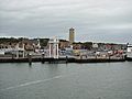
The beautiful isle of Terschelling
-
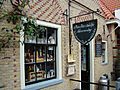
A shop in Terschelling
-
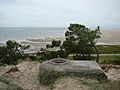
Another view of the isle of Terschelling
-
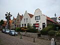
Commandeurstraat in Terschelling


See also
 In Spanish: Terschelling para niños
