
Ameland facts for kids
Quick facts for kids
Ameland
It Amelân
|
|||
|---|---|---|---|
|
Aerial view Ameland (west)
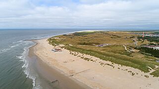
Ameland Beach
Museum Sorgdrager
Lighthouse
Maritime Museum
|
|||
|
|||

Location in Friesland
|
|||
| Country | Netherlands | ||
| Province | Friesland | ||
| Government | |||
| • Body | Municipal council | ||
| Area | |||
| • Total | 268.50 km2 (103.67 sq mi) | ||
| • Land | 58.83 km2 (22.71 sq mi) | ||
| • Water | 209.67 km2 (80.95 sq mi) | ||
| Elevation | 4 m (13 ft) | ||
| Population
(May 2014)
|
|||
| • Total | 3,591 | ||
| • Density | 61/km2 (160/sq mi) | ||
| Demonym(s) | Amelander | ||
| Time zone | UTC+1 (CET) | ||
| • Summer (DST) | UTC+2 (CEST) | ||
| Postcode |
9160–9164
|
||
| Area code | 0519 | ||
| Official name: Duinen Ameland | |||
| Designated: | 29 August 2000 | ||
| Reference #: | 2212 | ||


Ameland is a beautiful island off the north coast of the Netherlands. It is one of the West Frisian Islands. The island is mostly covered in sand dunes. It is the third largest of the West Frisian Islands.
Ameland is located next to Terschelling on its west side. To its east is the island of Schiermonnikoog. The small sandbanks Engelsmanplaat and Rif are also nearby. Ameland is the fourth inhabited Dutch Wadden island from the west. It belongs to the Friesland province. The entire island is one municipality, which means it has its own local government. The Wadden islands separate the North Sea from the Wadden Sea. The Wadden Sea is on the south side of the island chain. In 2014, about 3,591 people lived on Ameland. People from Ameland are called Amelanders.
Contents
Island Villages
Ameland has four main villages. There is also one very small part-village.
Long ago, there were two other villages called Oerd and Sier. Sadly, these villages were flooded by the sea. Their names live on through the ferries to the island, MS Oerd and MS Sier. The villages on Ameland, from west to east, are:
- Hollum: This is the biggest village on the island. It is on the west coast. You can find the island's lighthouse here.
- Ballum: This is the smallest village. It has the island's small airport, Ameland Airport.
- Nes: This is the second largest village. It is a busy place for tourists with many hotels. The island's secondary school, Burgemeester Waldaschool, is also here. Ferries from Holwert on the mainland arrive in Nes.
- Buren: This village is in the middle of the island. It is close to Ameland's beach.
Island Population
Here is how many people lived in each village in 2017:
| Village Name | Number of People |
| Hollum | 1,165 |
| Nes | 1,155 |
| Buren | 715 |
| Ballum | 350 |
Ameland's Past
Ameland was first mentioned in the 8th century. It was called Ambla back then. For a long time, it paid taxes to the county of Holland. But in 1424, its leader, Ritske Jelmera, said it was a "free lordship." This meant it was almost like its own small country.
Even though Holland, Friesland, and the Holy Roman Emperor disagreed, Ameland stayed a free lordship. This lasted until the ruling family, Cammingha, ended in 1708. After that, the leader of Friesland, John William Friso, Prince of Orange, became the lord of Ameland. Later, his son and grandson, who were leaders of all the Netherlands, also held this title.
Ameland officially became part of the Netherlands in 1813. It joined the province of Friesland. Even today, the Dutch royal family still uses the title Vrijheer van Ameland.
The Unsuccessful Dike
In 1871–72, people tried to build a dike between Ameland and the mainland. This dike was meant to reclaim land from the sea. It stretched about 8.7 kilometers (5.4 miles) from Holwert to Buren. The province and the Dutch government helped pay for it. However, the dike was not strong enough. After big storms in 1882, they stopped trying to fix it. You can still see parts of the old dike at low tide.
World War II
In 1940, German soldiers came to Ameland. The island was quickly taken over by the German Army. Because Ameland was not very important for fighting, the Allies (the countries fighting Germany) never attacked it. The German forces on Ameland did not give up until June 2, 1945. This was almost a month after Nazi Germany had been defeated.
The Fremantle Highway Fire

In July 2023, a large cargo ship called the MV Fremantle Highway caught fire. It was carrying over 3,700 cars off the coast of Ameland. The fire caused injuries to 22 sailors.
Amazing Nature
Ameland is a very special place for nature, just like all the West and East Frisian Islands. Many different plants grow on the island because it has so many types of landscapes. One beautiful area is the Oerd. This is a huge area of sand dunes that keeps growing every year.
Because of the different landscapes and plants, over 60 different kinds of birds visit the Oerd each year. On the eastern side of the Oerd, there is a flat beach area called the Hon. Besides dunes and beaches, Ameland also has some woods. One example is the Nesser bos, which means "Wood of Nes."
Getting Around
Most visitors travel to Ameland by ferry. The ferry leaves from Holwert on the mainland of Friesland. There is also a small airport near Ballum called Ameland Airport. A bus service connects the ferry port to the villages of Hollum, Ballum, Buren, and Nes.
When the sea between Friesland and Ameland is at low tide, it is possible to walk across the mudflats to the island. This is called mudflat hiking.
Famous People from Ameland

Here are some notable people who were born on Ameland:
- Ritske Jelmera (1383–1450): A Frisian leader who ruled Ameland.
- Hidde Dirks Kat: A famous whaler.
- Johannes de Jong (1885–1955): He became the Archbishop of Utrecht.
- Hannes de Boer (1899–1982): A long jumper who competed in the Olympic Games in 1924 and 1928.
- Sjoerd Soeters (born 1947): A modern architect.
- Pieter Mosterman (born 1967): A research scientist and professor in the USA.
- Jan Bruin (born 1969): A retired Dutch soccer player.
Gallery
-
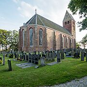
Hervormde Kerk in Hollum, Ameland
-
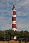
Bornrif lighthouse
-

Abandoned swimmingpool at Ameland
-
Ameland, Hollum beach dunes
.jpg)


See also
 In Spanish: Ameland para niños
