
Graham Road Covered Bridge facts for kids
Quick facts for kids Graham Road Bridge |
|
|---|---|
_Covered_Bridge_1.jpg) |
|
| Coordinates | 41°46′53″N 80°37′06″W / 41.78139°N 80.61833°W |
| Locale | Ashtabula County, Ohio, United States |
| Characteristics | |
| Design | single span, Town truss |
| Total length | 97 feet (29.6 m) |
| History | |
| Construction begin | 1913 |

Graham Road Bridge (red dot) in Ashtabula County
|
|
The Graham Road Bridge is a special kind of bridge called a covered bridge. It used to stretch over the west branch of the Ashtabula River in Pierpont Township, Ashtabula County, Ohio, United States. This bridge has a unique story because it was built using parts from an older bridge. That first bridge was damaged in a big flood in 1913.
Today, the Graham Road Bridge is no longer used for cars. Instead, it sits in an Ashtabula County MetroPark. You can find it along the south side of Graham Road, very close to where it originally stood. It's designed as a single span Town truss, which is a specific way bridges are built. The bridge was moved to its current spot in 1972. It's about 8.4 miles (13.5 km) east-northeast of Jefferson.
Contents
History of the Graham Road Bridge
The Graham Road Bridge has an interesting past, especially since it was rebuilt from an older structure.
When Was the Bridge Built?
- 1913 – The Graham Road Bridge was first built. It was made from pieces of an earlier bridge that had been damaged by a flood that same year.
When Was the Bridge Moved?
- 1972 – The bridge was carefully moved from its original location over the river. It was placed in the nearby MetroPark, where it now serves as a historical landmark.
How Big is the Graham Road Bridge?
The Graham Road Bridge is quite long for a covered bridge.
Bridge Length
- Length: The bridge measures 97 feet (29.6 meters) from one end to the other.
Pictures of the Bridge
Here are some more pictures of the Graham Road Bridge.
-
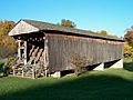
View from the southwest
-
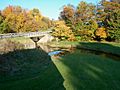
View from the east end of the bridge, looking toward its former site
_Covered_Bridge_2.jpg)
_Covered_Bridge_3.jpg)
