Ashtabula River facts for kids
Quick facts for kids Ashtabula River |
|
|---|---|

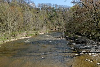
The Ashtabula River as viewed from the Riverview Covered Bridge
|
|

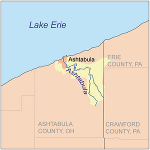
Map of the Ashtabula River and its watershed
|
|
| Country | United States of America |
| State | Ohio |
| County | Ashtabula County |
| Physical characteristics | |
| Main source | Confluence of east and west branches in Monroe Township, Ashtabula County 850 feet (260 m) 41°48′51″N 80°36′57″W / 41.81417°N 80.61583°W |
| River mouth | Lake Erie at Ashtabula, Ohio 571 feet (174 m) 41°54′36″N 80°47′55″W / 41.91000°N 80.79861°W |
| Length | 40 miles (64 km) |
| Basin features | |
| Basin size | 137 square miles (350 km2) |
The Ashtabula River is a river in Ohio, located northeast of Cleveland. It flows into Lake Erie near the city of Ashtabula, Ohio. This river is about 40 miles (64 km) long. Its watershed, which is the area of land where all the water drains into the river, covers 137 square miles (350 km2).
Contents
What's in a Name?
The name Ashtabula comes from the Lenape language. It means 'always enough fish to go around' or 'to be given away'. This name shows that the river was a good place for fishing long ago.
According to the Geographic Names Information System, the Ashtabula River has also been known by a few other names:
- Ashtibula River
- Riviere Auscubalu
- Riviere Oscubolu
The Ashtabula River Watershed
The Ashtabula River and its watershed are very important to the local environment. On October 30, 2008, the river was officially named a State Scenic River by the Ohio Department of Natural Resources. This means it is recognized for its natural beauty and importance.
Cleaning Up the River
In 1985, the first two miles of the river were called an Area of Concern by the International Joint Commission. This was mainly because of Fields Brook, a smaller stream that flows into the Ashtabula River. Between the 1940s and 1970s, many factories had released waste into Fields Brook. This caused pollution in the river.
However, a big cleanup effort began to make the river healthy again. This important work was finished in 2014. Now, the river is much cleaner and safer for wildlife and people.
Smaller Streams Joining the River
Many smaller streams, called tributaries, flow into the Ashtabula River. These include:
- Fields Brook
- Strong Brook
- Hubbard Run
- Ashtabula Creek
- West Branch Ashtabula River
- East Branch Ashtabula River
 | Roy Wilkins |
 | John Lewis |
 | Linda Carol Brown |

