Grand Canyon of the Stikine facts for kids
Quick facts for kids Grand Canyon of the Stikine |
|
|---|---|

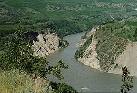
Grand Canyon of the Stikine River near Telegraph Creek
|
|
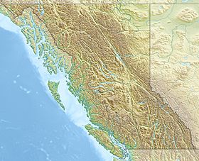
| Coordinates | 58°05′00″N 130°45′00″W / 58.08333°N 130.75000°W |
| Part of | Tahltan Highland |
| Length | 72 kilometres (45 mi) |
| Formed by | Stikine River |
The Grand Canyon of the Stikine is an amazing 72-kilometer (about 45-mile) long canyon. It is located along the Stikine River in northern British Columbia, Canada. Many people compare it to the famous Grand Canyon in the United States.
This canyon is a home for many mountain goats and other wild animals. It is also known as one of the most challenging rivers in the world for expert whitewater paddlers. Since the first try in 1981, many skilled adventurers have successfully traveled through it. Among whitewater experts, the Grand Canyon of the Stikine is often called the 'Mt. Everest' of big water rivers. It is the ultimate test for paddlers.
What Makes the Canyon Special?
The Grand Canyon of the Stikine starts around the 130th line of longitude, south of Tsenaglode Lake. The first road bridge over the Stikine River was built in the 1970s. This bridge is part of the Stewart-Cassiar Highway. It is located just before the canyon section begins.
The canyon section finishes near the community of Telegraph Creek. The canyon has very steep walls. It was formed over a long time as the Stikine River cut through layers of sedimentary rock and volcanic rock. In some places, the canyon is 300 meters (about 984 feet) deep!
The Stikine River changes a lot in width as it flows through the canyon. It can be as wide as 200 meters (about 656 feet). But in one spot, where the Tanzilla River joins, it narrows down to just 2 meters (about 6.5 feet) wide. Kayakers call this very narrow part the "Vanilla Slot." Some people also call the canyon "The big red" because of its color and huge size.
Protecting the River
In 1980, a company called BC Hydro started looking into building five dams in the Grand Canyon. However, many groups, including conservationists and Indigenous communities, strongly disagreed with this plan. They fought for a long time to protect the river.
Because of these efforts, the Stikine River Provincial Park was created in 2001. This large park, covering 257,177 hectares (about 635,500 acres), helps protect this special part of the river.
Amazing Boat Journeys
The Grand Canyon of the Stikine is considered one of the toughest kayaking challenges on Earth. Kayaker Doug Ammons described it as "one of the most challenging runs anybody has ever found on this planet." Its whitewater has many very difficult rapids, known as "grade V+" rapids.
Every fall, some of the world's best expedition kayakers try to paddle through the canyon. It's like a special test for them. These trips are usually planned as expeditions and take about three days to finish. However, a few very skilled kayakers have completed the entire journey in just one day. The first one-day trip was in 2005, by Daniel DeLaVergne, John Grace, Tommy Hilleke, and Tobin MacDermott.
Most paddlers try the canyon in early fall. This is when the water level is lower. At this time, the water flow is between 4,000 and 13,000 cubic feet per second. The water level can even change by as much as 10 feet (3 meters) in a single day!
For much of the canyon, the cliffs are so steep that it's almost impossible to climb out if you need to. If a paddler does manage to climb out, they then face a very long and hard hike through the Canadian wilderness. This hike can take many hours or even days to reach a road.
The American kayaker Rob Lesser first saw the canyon in 1977 while flying over it. He noticed many difficult rapids. In 1981, Lesser and fellow kayakers John Wasson, Lars Holbek, Don Banducci, and Rick Fernald made the first attempt to paddle the canyon. They had helicopter support and a film crew. They completed about 60% of the canyon. One team member, John Wasson, nearly drowned in a rapid now called Wasson's Hole.
In 1985, Lesser and Holbek, along with Bob McDougall, tried again to kayak the entire canyon. A raft team also joined them. This expedition had helicopter support for filming and safety. The trip took longer than planned because of changing water levels and careful scouting of the rapids. The film crew eventually left, but Lesser, Holbek, and McDougall continued. They completed the entire canyon, except for one rapid called Site Zed. A film about their journey was called "Hell and High Water."
In 1990, the entire river was paddled for the first time without any helicopter support. Rob Lesser led a group on this first self-supported trip. Four days later, Phil DeReimer, Hayden Glatte, and Bryan Tooley completed the second self-supported trip. Their journey proved that it was possible to complete the river without helicopter scouting.
 | Georgia Louise Harris Brown |
 | Julian Abele |
 | Norma Merrick Sklarek |
 | William Sidney Pittman |


