Gravel Switch, Livingston County, Kentucky facts for kids
Quick facts for kids
Gravel Switch, Kentucky
|
|
|---|---|

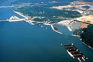
Dam, quarries, and port in area
|
|
| Country | United States |
| State | Kentucky |
| County | Livingston |
| Elevation | 387 ft (118 m) |
| Time zone | UTC-6 (Central (CST)) |
| • Summer (DST) | UTC-5 (CST) |
| GNIS feature ID | 493181 |
Gravel Switch is a special area in Livingston County, Kentucky. It is located along the Paducah & Louisville Railway (PAL). This spot is found between the Kentucky Dam on the Tennessee River and Grand Rivers. It is also near where U.S. Route 62 and Kentucky Route 453 meet.
The gravel from this area was once very important. It was known as one of the best types of gravel for building track ballast for railroad tracks. Today, Gravel Switch is still a busy place. It works as a terminal for trains and barges. It helps move large amounts of crushed rock for a company called Vulcan Materials.
History of Gravel Switch
Early Railroad Days
In the early 1900s, a railroad company called the Illinois Central Railroad used this area. They had a special short rail line, called a spur line, that went to Gravel Switch. This spur line was part of their Kentucky Division. Workers used it to collect rock from the area. This rock was then used as track ballast. Track ballast is the crushed stone that supports and holds up railroad tracks. Old maps from 1936 show how these rail lines looked.
Changes from Kentucky Dam
Later, the Kentucky Dam was built. The Tennessee River basin filled up with water. This happened around 1955. When the water rose, about half of the Gravel Switch area went underwater. Part of the original rail line was also submerged.
The railroad line had to be moved. It was re-routed to go over the dam. The new path also went through the Gravel Switch spur area. This part was kept above the water level. The difference in height was about 36 feet (11 meters).
 | Shirley Ann Jackson |
 | Garett Morgan |
 | J. Ernest Wilkins Jr. |
 | Elijah McCoy |


