Green Grove, Wisconsin facts for kids
Quick facts for kids
Green Grove, Wisconsin
|
|
|---|---|

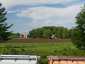
A small farm viewed from the railroad overpass on Robin Avenue
|
|

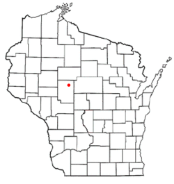
Location of Green Grove, Wisconsin
|
|
| Country | |
| State | |
| County | Clark |
| Area | |
| • Total | 36.2 sq mi (93.8 km2) |
| • Land | 36.0 sq mi (93.2 km2) |
| • Water | 0.2 sq mi (0.5 km2) |
| Elevation | 1,276 ft (389 m) |
| Population
(2010)
|
|
| • Total | 756 |
| • Density | 21/sq mi (8.1/km2) |
| Time zone | UTC-6 (Central (CST)) |
| • Summer (DST) | UTC-5 (CDT) |
| Area code(s) | 715 & 534 |
| FIPS code | 55-31275 |
| GNIS feature ID | 1583317 |
| PLSS township | T21N R1W |
Green Grove is a town in Clark County, Wisconsin. In 2010, about 756 people lived here. This was fewer than the 902 people who lived here in 2000. Two small communities, Atwood and Bright, are also part of the town.
Contents
Green Grove's Location and Land
Green Grove is located in the northeastern part of Clark County. The city of Owen is to its northwest. The village of Curtiss is at its northeast corner.
The town covers a total area of about 93.8 square kilometers (36.2 square miles). Most of this area, 93.2 square kilometers (36.0 square miles), is land. A small part, 0.5 square kilometers (0.2 square miles), is water.
Land Features and Soil
Most of Green Grove's land is quite flat. The soil is mostly deep and silty. It can be poorly drained or moderately well-drained. This type of soil is found on ground moraines, which are landforms left by glaciers.
The rock underneath the ground is mostly Mount Simon sandstone. There are also some areas with volcanic and metavolcanic rock.
History of Green Grove
The history of Green Grove began with surveyors. These early European Americans mapped the area. From 1845 to 1847, they walked the land. They used chains and compasses to map the township's outer edges.
In January 1853, more surveyors returned. They mapped all the smaller sections of land. After their work, a surveyor described the area. He noted that much of it was swampy and not good for farming. He also mentioned thick pine and elm trees.
Early Land Sales and Settlements
Once the land was mapped, the U.S. government started selling it. They sold parcels to people and lumber companies. The first land sale in Green Grove happened in 1856. John Lewis bought 40 acres in section 11.
By 1880, the area was the western part of an early Town of Colby. A road, now called County E, existed. A Green Grove post office was located where County E meets Eddy Road today.
Early settlers had farms ranging from 40 to 160 acres. Beyond the first mile, large parts were owned by lumber companies. D.J. Spaulding Estate owned the most land. J.S. Keator and Bright and Withee also owned large areas.
Town Formation and Growth
A wagon road, now County N, crossed the township. In 1886, the 6-mile by 6-mile Town of Green Grove was officially separated from the Town of Colby.
By 1906, more roads and farms had appeared. However, much of western and northern Green Grove was still owned by lumber companies. These included J.S. Owen and H.A. Bright.
The Fairchild and Northeastern Railroad was being built. It curved across the western part of the township. This railroad connected Willard to Owen. The Bright post office was located where this railroad crossed County N.
Several schoolhouses were built. One was on County N, another on Sparrow Road. Others were on Oak Grove Avenue and N west of Oak Grove. A town hall was at the intersection of N and Romadka.
Railroads and Communities
In 1910, the Soo Line Railroad built a new line. It ran diagonally across Green Grove. This line connected Spencer with Owen. Before this, trains had to take a longer route.
The railroad added sidings, which are short tracks. This led to the growth of Atwood. A 1918 history book described Atwood as a "new village." It had a railroad station, a store, and a saloon.
The same book described Bright. Bright was on the Fairchild and Northeastern railroad. It had a station, a store, and a cheese factory. An old sawmill there was no longer in use.
By 1920, many parts of Green Grove were filled with farms. A cheese factory opened at Romadka and Oak Road. This showed that the area was changing from logging to dairy farming.
Green Grove's Population
In 2000, Green Grove had 902 people living in 225 households. About 177 of these were families. The population density was about 24.7 people per square mile. There were 236 housing units.
Diversity and Households
Most of the people in Green Grove were White (98.89%). A small number were Native American or Asian. Some people were from two or more races. About 0.44% of the population was Hispanic or Latino.
Out of 225 households, 39.1% had children under 18. Most households (68.9%) were married couples. About 5.8% had a female head of household with no husband. About 20.9% were not families.
Some households (16.0%) had only one person. About 8.9% had someone living alone who was 65 or older. The average household had 3.11 people. The average family had 3.57 people.
Age and Income
The population's age was spread out. About 27.4% were under 18. About 25.9% were 65 or older. The median age was 41 years. For every 100 females, there were about 96.1 males.
The median income for a household in the town was $37,667. For a family, it was $41,023. Males earned more than females on average. The average income per person in the town was $14,067.
About 10.4% of families and 13.1% of all people lived below the poverty line. This included 18.7% of those under 18 and 14.8% of those 65 or older.
See also
 In Spanish: Green Grove (Wisconsin) para niños


