Guanay Municipality facts for kids
Quick facts for kids
Guanay Municipality
|
|
|---|---|
|
Municipality
|
|

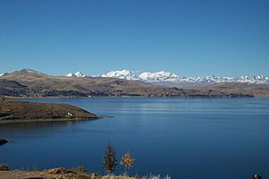
The Cordillera Real as seen from Lake Titicaca with Chachakumani and Ch'iyar Juqhu of the Guanay Municipality in the center
|
|
| Country | |
| Department | La Paz Department |
| Province | Larecaja Province |
| Seat | Guanay |
| Area | |
| • Total | 1,510 sq mi (3,911 km2) |
| Elevation | 1,600 ft (500 m) |
| Population
(2001)
|
|
| • Total | 11,528 |
| Time zone | UTC-4 (BOT) |
Guanay Municipality is a special area in Bolivia, located in the La Paz Department. It's like a district within the Larecaja Province. The main town, or 'seat,' of this municipality is called Guanay. In the Aymara language, it's known as Wanay.
Exploring Guanay's Geography
Guanay Municipality is a mountainous region. The amazing Cordillera Real mountain range runs right through it. Some of the highest peaks in this range are found here. These include Chachakumani and Ch'iyar Juqhu.
Many other mountains are also part of this municipality, making it a place with stunning views and challenging terrain. Some of these peaks are:
- Aqhuya Aqhuyani
- Imasiña
- Jach'a Pata
- Janq'u K'ark'a
- Kuntur Jipiña
- Ñuñuni Qalani
- Pallqa K'ark'a
- Patapatani
- Qillwani
- Turini
- Wari Qalluni Pata
- Wila Lluxita
- Wila Umani
- Wila Wila
Languages Spoken in Guanay
People in Guanay Municipality speak several languages. The most common ones are Spanish, Aymara, and Quechua.
Here's a look at how many people speak each language, based on information from 2001:
| Language | Number of Speakers |
|---|---|
| Quechua | 1,653 |
| Aymara | 3,405 |
| Guaraní | 5 |
| Another native language | 94 |
| Spanish | 10,064 |
| Foreign language | 86 |
| Only a native language | 737 |
| Native and Spanish | 4,123 |
| Only Spanish | 5,942 |
Ref.: obd.descentralizacion.gov.bo
See also
 In Spanish: Guanay (municipio) para niños


