
Guatemala, San Sebastián, Puerto Rico facts for kids
Quick facts for kids
Guatemala
|
|
|---|---|
|
Barrio
|
|
  Clockwise from top:
Panorama of Guatemala, Trees at Veredas Sports Complex |
|

Location of Guatemala within the municipality of San Sebastián shown in red
|
|

Guatemala, San Sebastián, Puerto Rico
Location in Caribbean
|
|
| Commonwealth | |
| Municipality | |
| Area | |
| • Total | 2.16 sq mi (5.6 km2) |
| • Land | 2.16 sq mi (5.6 km2) |
| • Water | 0 sq mi (0 km2) |
| Elevation | 223 ft (68 m) |
| Population
(2010)
|
|
| • Total | 2,512 |
| • Density | 1,163/sq mi (449/km2) |
| Source: 2010 Census | |
| Time zone | UTC−4 (AST) |
Guatemala is a special area called a barrio in the town of San Sebastián, Puerto Rico. In 2010, about 2,512 people lived there. The Guatemala River also flows through this barrio.
Contents
A Look at Guatemala's Past

After the Spanish–American War, Puerto Rico became a territory of the United States. This happened under the Treaty of Paris of 1898. In 1899, the United States government counted the people in Puerto Rico. They found that Guatemala barrio and a nearby area called Bahomamey barrio had a total of 1,126 residents.
For many years, a big sugar factory operated in Guatemala. However, it is no longer in use today.
| Historical population | |||
|---|---|---|---|
| Census | Pop. | %± | |
| 1980 | 2,544 | — | |
| 1990 | 3,030 | 19.1% | |
| 2000 | 2,919 | −3.7% | |
| 2010 | 2,512 | −13.9% | |
| U.S. Decennial Census 1899 (shown as 1900) 1910-1930 1930-1950 1980-2000 2010 |
|||
Smaller Areas: Sectors
Barrios like Guatemala are divided into even smaller local areas. These are called sectores (which means sectors in English). There are different types of sectors. Some are simply called sector. Others might be called urbanización, reparto, barriada, or residencial.
Here are some of the sectors you can find in Guatemala barrio:
- Avenida Emérito Estrada Rivera
- Carretera 111
- Carretera 125
- Carretera 445
- Carretera 446
- Sector Barandillo
- Sector Bejuco
- Sector Central Plata
- Sector Colón
- Sector Goyin Rámirez
- Sector Javilla
- Sector Laberinto
- Sector La Vega
- Sector Marcelo Pérez
- Sector Méndez
- Sector Peña
- Sector Rincón (Gozalandia)
- Sector Salsipuedes
- Sector Torres
- Urbanización Extensión Villa Rita
- Urbanización Jardines de Guatemala
- Urbanización Mansiones de Loma Linda
- Urbanización San Antonio de La Plata
- Urbanización San Carmelo de la Plata
- Urbanización Villa Rita
Cool Places to Visit
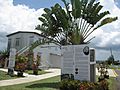
The Guatemala River flows right through the Guatemala barrio in San Sebastián. You can also find a sports complex here. This complex has a museum that tells the story of an old farm, called an hacienda. The San Sebastián Memorial is also located in Guatemala.
Veredas Sports Complex: Fun and Nature
The Veredas Sports Complex opened in Guatemala in 2016. It's a great place for outdoor activities! The complex has:
- A modern skate park
- A sand volleyball court
- A zipline with four different stations
- A wall for climbing and rappelling
- An outdoor gym
- A rope bridge
- Courts for basketball and tennis
- Walking paths
All these fun features are set within a special "urban forest" that has about six thousand trees. Inside the complex, you can also visit the Hacienda La Fe, which is a museum about farming history.
Gallery
-
Rock climbing wall at Veredas Sports Complex in Guatemala
-
Hacienda la Fe museum at Veredas Sports Complex in Guatemala
-
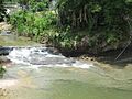
Guatemala River in Guatemala
-
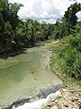
Guatemala River in Guatemala barrio
-
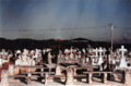
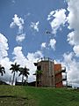
San Sebastián Memorial


See also
 In Spanish: Guatemala (Puerto Rico) para niños
- List of communities in Puerto Rico
- List of barrios and sectors of San Sebastián, Puerto Rico
