Honaunau-Napoopoo, Hawaii facts for kids
Quick facts for kids
Honaunau-Napo’opo’o, Hawaii
Hōnaunau-Nāpōʻopoʻo
|
|
|---|---|

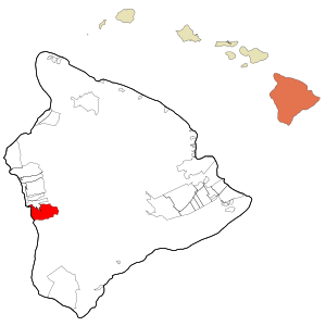
Location in Hawaii County and the state of Hawaii
|
|
| Country | United States |
| State | Hawaii |
| County | Hawaiʻi |
| Area | |
| • Total | 41.89 sq mi (108.49 km2) |
| • Land | 38.01 sq mi (98.43 km2) |
| • Water | 3.88 sq mi (10.06 km2) |
| Elevation | 750 ft (230 m) |
| Population
(2020)
|
|
| • Total | 2,416 |
| • Density | 63.57/sq mi (24.54/km2) |
| Time zone | UTC−10 (Hawaii-Aleutian) |
| Area code(s) | 808 |
| FIPS code | 15-16160 |
| GNIS feature ID | 2414045 |
Hōnaunau-Nāpōʻopoʻo is a special kind of community in Hawaiʻi County, Hawaii, United States. It's called a "census-designated place" (CDP), which means it's an area grouped together for counting people. In 2020, about 2,416 people lived here.
Contents
Exploring Hōnaunau-Nāpōʻopoʻo's Location
Hōnaunau-Nāpōʻopoʻo is found on the western side of the big island of Hawaiʻi. It sits right next to the Pacific Ocean on its west side. To the north, you'll find the Captain Cook community.
This area includes two smaller, well-known places:
- Hōnaunau is in the southwest part of the CDP, located on Hōnaunau Bay.
- Nāpōʻopoʻo is in the northwest part, right on Kealakekua Bay.
Getting Around Hōnaunau-Nāpōʻopoʻo
Hawaii Route 11 is the main road that goes through Hōnaunau-Nāpōʻopoʻo. If you drive north on this road, you'll reach Kailua-Kona in about 16 miles. If you head south, you'll get to Nāʻālehu in about 43 miles. There's also Hawaii Route 160, which is a winding road that connects the communities of Hōnaunau and Nāpōʻopoʻo.
Size of the Area
The total area of Hōnaunau-Nāpōʻopoʻo is about 105.4 square kilometers (or 40.7 square miles). Most of this area, about 98.4 square kilometers (38.0 square miles), is land. The rest, about 7.0 square kilometers (2.7 square miles), is water.
Weather in Hōnaunau-Nāpōʻopoʻo
Nāpōʻopoʻo has a tropical monsoon climate. This means it has warm temperatures all year round. It also gets a lot of rain, especially during certain months.
Climate Details
The weather information for Nāpōʻopoʻo comes from the Western Regional Climate Center. This data helps us understand the typical temperatures and rainfall in the area.
| Climate data for Nāpōʻopoʻo | |||||||||||||
|---|---|---|---|---|---|---|---|---|---|---|---|---|---|
| Month | Jan | Feb | Mar | Apr | May | Jun | Jul | Aug | Sep | Oct | Nov | Dec | Year |
| Mean daily maximum °F (°C) | 80.2 (26.8) |
80.2 (26.8) |
80.6 (27.0) |
81.2 (27.3) |
81.3 (27.4) |
81.8 (27.7) |
83.1 (28.4) |
84.1 (28.9) |
83.9 (28.8) |
83.4 (28.6) |
82.2 (27.9) |
80.5 (26.9) |
81.9 (27.7) |
| Mean daily minimum °F (°C) | 60.6 (15.9) |
60.4 (15.8) |
60.5 (15.8) |
61.8 (16.6) |
62.8 (17.1) |
64.0 (17.8) |
64.1 (17.8) |
65.2 (18.4) |
64.8 (18.2) |
64.4 (18.0) |
63.3 (17.4) |
61.3 (16.3) |
62.8 (17.1) |
| Average rainfall inches (mm) | 2.52 (64) |
1.92 (49) |
2.68 (68) |
3.19 (81) |
3.54 (90) |
3.23 (82) |
3.76 (96) |
3.84 (98) |
4.07 (103) |
3.25 (83) |
2.49 (63) |
2.08 (53) |
36.57 (930) |
| Source: WRCC | |||||||||||||
Who Lives Here?
| Historical population | |||
|---|---|---|---|
| Census | Pop. | %± | |
| 2020 | 2,416 | — | |
| U.S. Decennial Census | |||
In 2020, the census counted 2,416 people living in Hōnaunau-Nāpōʻopoʻo. A census is like a big count of everyone living in a country, done every ten years.
Learning in Hōnaunau-Nāpōʻopoʻo
The Hawaiʻi Department of Education is in charge of the public schools in this area. Hōnaunau Elementary School is located right within the Hōnaunau-Nāpōʻopoʻo community.
See also
 In Spanish: Honaunau-Napoopoo para niños


