
Haleets facts for kids
| Glacial erratic rock | |

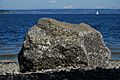
Haleets at low tide. Most of the petroglyphs are concealed beneath barnacles.
|
|
| Coordinates | 47°43′07.1″N 122°32′40.1″W / 47.718639°N 122.544472°W |
|---|---|
| Composition | |
| Sandstone | |
Haleets (also known as Figurehead Rock) is a special rock found on Bainbridge Island, Washington. It's a huge glacial erratic boulder, which means it was moved by a glacier a long, long time ago. This rock has amazing pictures carved into it called petroglyphs.
The Suquamish Tribe, a Native American group, considers Haleets a very important part of their history. The rock sits on a public beach at Agate Point, right by the water of Agate Pass. No one knows exactly when the carvings were made. Experts think they might be from around 1000 BCE to 400 or 500 CE.

What is Haleets?
The name Haleets comes from the Coast Salish language. It has also been written as Halelos, Xalelos, and Xalilc. All these names mean "marked face," which makes sense because of the carvings on the rock. In English, it's also called Figurehead Rock.
No one is completely sure why the petroglyphs were carved. Charlie Sigo, a curator at the Suquamish Museum, thinks it might have been a boundary marker. This means it could have shown where one area ended and another began.
A Rock with a Story
Haleets is about 5 feet (1.5 meters) tall and 7 feet (2.1 meters) long. It sits about 100 feet (30 meters) from the shore. Over the years, people have added their own marks to the rock. Since 1856, it has had chiseled and drilled marks from Coast Survey teams. In 1934, a bronze geodetic mark was placed on it. These marks help mapmakers and scientists.
Some people believe Haleets was always on the shoreline. However, movement of the Earth's crust, called tectonic activity, near the Seattle Fault might have moved Haleets into the area where the tide goes in and out. This area is called the intertidal zone.

Images for kids
-
Haleets Rock, looking northwest from the beach. Petroglyphs are on the side facing the water.

