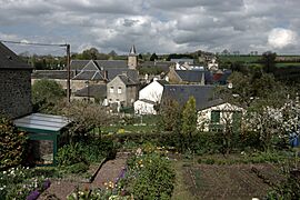
Hamars facts for kids
Quick facts for kids
Hamars
|
|
|---|---|
|
Part of Thury-Harcourt-le-Hom
|
|
 |
|
| Country | France |
| Region | Normandy |
| Department | Calvados |
| Arrondissement | Caen |
| Canton | Le Hom |
| Commune | Thury-Harcourt-le-Hom |
| Area
1
|
9.44 km2 (3.64 sq mi) |
| Population
(2019)
|
461 |
| • Density | 48.83/km2 (126.48/sq mi) |
| Time zone | UTC+01:00 (CET) |
| • Summer (DST) | UTC+02:00 (CEST) |
| Postal code |
14220
|
| Elevation | 67–272 m (220–892 ft) (avg. 252 m or 827 ft) |
| 1 French Land Register data, which excludes lakes, ponds, glaciers > 1 km2 (0.386 sq mi or 247 acres) and river estuaries. | |
Hamars (French pronunciation: [amaʁ]) was a small village, also known as a commune, located in northwestern France. It was part of the Calvados area, which is like a county, within the larger Normandy region. On January 1, 2016, Hamars joined with other nearby villages to form a new, bigger commune called Thury-Harcourt-le-Hom.
About Hamars
Hamars was a charming French commune, which is a local administrative area, similar to a town or village. It was located in the Calvados department, a region in northwestern France. The village was known for its quiet, rural setting.
Geography and Nature
The area where Hamars was located is known as Suisse Normande. This name means "Norman Switzerland." It is called this because of its beautiful, hilly landscapes. The region has deep valleys and rocky cliffs, much like parts of Switzerland. It is a popular spot for outdoor activities.
Population Over Time
The number of people living in Hamars changed over the years. Like many small villages, its population went up and down. Here is a look at how many people lived there at different times:
| Historical population | ||
|---|---|---|
| Year | Pop. | ±% |
| 1962 | 274 | — |
| 1968 | 232 | −15.3% |
| 1975 | 231 | −0.4% |
| 1982 | 346 | +49.8% |
| 1990 | 343 | −0.9% |
| 1999 | 390 | +13.7% |
| 2008 | 420 | +7.7% |
See also
 In Spanish: Hamars para niños
 | May Edward Chinn |
 | Rebecca Cole |
 | Alexa Canady |
 | Dorothy Lavinia Brown |


