
Hapua facts for kids

Hapua is a special word from the Māori people of New Zealand. It describes a unique type of lagoon that forms at the mouth of a river, right where the river meets the sea. These lagoons are found on beaches made of a mix of sand and gravel.
Hapua usually form where a river, often one with many small channels (called a braided river), flows into a coastal area. In these areas, sand and gravel are constantly moved along the coast by ocean currents. This movement is called 'longshore drift'.
The river carves out a long, narrow pool of water that runs parallel to the coast. A natural barrier of sand and gravel separates this pool from the open ocean. This barrier is always changing shape because of the moving sand and gravel. Most of the water from the hapua flows into the ocean through a temporary channel that often moves around. Some water also seeps through the sandy barrier.
Hapua are special because they are always changing. Their shape depends on how strong the river flow is and how powerful the ocean waves and currents are. You can find hapua at the mouths of rivers like the Rakaia, Ashburton, and Hurunui in New Zealand.
Where Do Hapua Form?
Hapua are often found along the east coast of the South Island of New Zealand, especially in a place called the Canterbury Bight. This area has beaches made of coarse sand and gravel, ranging from tiny grains to large boulders. These beaches face strong ocean waves.
The beaches where hapua form are very steep. This steepness means that waves break right on the shore, and the water rushes up and down the beach quickly. There isn't a wide area of breaking waves like on some sandy beaches. Hapua form here because the mixed sand and gravel barrier allows some water to seep through it.
The east coast of the South Island is slowly eroding, losing about half a meter of land each year. This happens because the rivers don't bring enough new sand and gravel to the coast to replace what the strong waves and longshore drift carry away. As the coastline erodes, hapua also move inland, keeping their shape as coastal features.
Hapua also form in places with small tides. A 'micro-tidal' environment means the difference between high tide and low tide is less than two meters. In these areas, the river's freshwater flow is much stronger than the ocean's tidal currents. This means that ocean tides don't push much saltwater into the hapua lagoon.
Another important factor for hapua formation is strong longshore drift. This is when sand and gravel are moved along the coast by waves hitting the shore at an angle. In the Canterbury Bight, the main direction of waves is from the south, so sand and gravel mostly move north. This constant movement helps build the barrier that creates the hapua.
The sand and gravel that form the hapua barrier come from a few places:
- From the Southern Alps: Rivers carry eroded material from these mountains across the Canterbury Plains to the coast.
- From coastal cliffs: High cliffs near the lagoons can erode during big river floods or sea storms.
- From southern beaches: Sand and gravel from beaches further south are carried north by longshore drift.
How Hapua Change
Hapua are always changing their size and shape. This happens because of the balance between the river's power and the ocean's power, as well as the condition of the sand and gravel barrier. The barrier itself constantly changes due to longshore drift.
The water in a hapua is mostly fresh water from the river. Saltwater from the ocean usually doesn't flow into the lagoon. However, the ocean tide does affect the water level in the hapua. When the tide is high, the ocean water level is higher, making it harder for the hapua water to flow out. This causes the hapua water level to rise slightly. Saltwater might only get into the hapua during a big storm, when waves crash over the barrier.
Hapua can both collect and release sand and gravel. When the river flow is low or medium, coarser sand and gravel tend to settle in the hapua. Finer sand might be carried out to the ocean through the hapua's outlet channel. During floods, the hapua gets "flushed out," and large amounts of sand and gravel are carried through the outlet into the ocean. This material can then settle offshore or further down the coast, helping to replenish the beach.
The shape of a hapua changes depending on how strong the river is and how strong the ocean is.
- Ocean processes include wave direction, wave height, and whether storms happen at high tide. These usually control the hapua's shape until a very large flood from the river breaks through the barrier.
- River processes are about how much water flows in the river, especially during floods.
The condition of the barrier (how permeable it is, its size, and height) also matters. When the river flow is low to medium, the hapua's outlet channel often gets pushed sideways by longshore drift. If the outlet gets too far from the main river channel, it can become blocked with sand and gravel, causing the hapua to close temporarily.
A big flood event in the river can break through the barrier directly opposite the main river channel. This causes the hapua's water level to drop quickly and sends a lot of stored sand and gravel into the ocean. Floods are important because they help erode the back of the lagoon, allowing the hapua to move inland as the coastline changes.
Storms can also close hapua outlets. Strong waves can wash over the barrier, depositing sand and gravel and blocking the channel. When this happens, the hapua's water level rises quickly. This pressure can then cause a new outlet to break through the barrier very fast. Storms are an important, but unpredictable, way that hapua outlets reopen, especially for smaller hapua.
Hapua are very important for many reasons:
- They connect the river and the sea, acting as a pathway for fish that migrate between fresh and saltwater.
- They provide a corridor for migratory birds. Losing this connection could harm entire species that need to move between the river and ocean as part of their life cycle.
- Historically, Māori people used river-mouth lagoons like hapua for mahinga kai (gathering food). However, this is less common now due to changes in the river catchments.
The Rakaia River Hapua

The hapua at the mouth of the Rakaia River is a good example. It stretches about three kilometers north from where the river meets the coast. Between 1952 and 2004, the hapua was usually about 50 meters wide. Its surface area has stayed around 600,000 square meters since 1966.
The land behind the coast here has cliffs that can erode and a low-lying area known as the Rakaia Huts. This area has changed a lot since European settlement, with wetlands being drained and a small community of holiday homes developing.
The Rakaia River starts in the Southern Alps and carries a huge amount of sand and gravel to the east coast each year. It is a braided river with a large area that collects water (3,105 square kilometers) and an average flow of 221 cubic meters per second. The river mouth is southwest of Banks Peninsula. As the river reaches the coast, it splits into two channels, with the main channel flowing south. Because the hapua is in the Canterbury Bight, it is always changing shape due to strong southerly ocean waves and the resulting northward longshore drift.
Images for kids
-
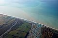
Coastal lagoon at the mouth of the Rakaia river, Canterbury Plains
-
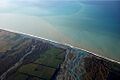
Aerial photograph of the Rakaia River-mouth and associated hapua
See also
 In Spanish: Hapua para niños
