Canterbury Bight facts for kids
Quick facts for kids Canterbury Bight |
|
|---|---|

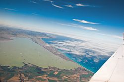
Aerial view of Kaitorete Spit and Lake Ellesmere / Te Waihora, showing the northern end of the Canterbury Bight
|
|
| Location | Canterbury, New Zealand |
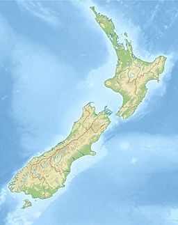
| Coordinates | 44°15′S 171°38′E / 44.250°S 171.633°E |
| Type | Oceanic bight |
| Primary inflows | Lake Ellesmere / Te Waihora, Rakaia River, Ashburton River / Hakatere, Rangitata River |
| Primary outflows | Pacific Ocean |
| Basin countries | New Zealand |
| Settlements | Timaru |
The Canterbury Bight is a big curve of coastline on the eastern side of New Zealand's South Island. It stretches for about 135 kilometres (84 mi) from the southern end of Banks Peninsula down to Timaru. This part of the coast faces southeast, which means it gets hit by strong storm waves from the Pacific Ocean.
Because of these powerful waves, the Canterbury Bight often has rough conditions. Waves taller than 2 metres (6.6 ft) are common here. Many large rivers, like the Rakaia, Ashburton / Hakatere, and Rangitata, flow into the Pacific Ocean along this bight. These rivers bring a lot of sand and gravel, mostly a type of rock called Greywacke. This material settles along the coast and can spread up to 50 kilometres (31 mi) out to sea.
You can also find several hapua along the bight. These are special lagoons that form at river mouths. They happen when waves pile up enough sand and gravel to create a barrier across the river's opening. Two well-known examples are Lake Ellesmere / Te Waihora and Washdyke Lagoon.
Contents
Exploring the Canterbury Bight's Zones
The Canterbury Bight can be divided into three main areas: the Southern Zone, the Central Zone, and the Northern Zone. Each zone has its own unique features.
The Southern Zone: Timaru to Rangitata
The Southern Zone is the southernmost part of the Canterbury Bight. It runs from Dashing Rocks near Timaru to the mouth of the Rangitata River. Important features in this zone include the Washdyke Barrier and Washdyke Lagoon.
The Central Zone: Where Rivers Meet the Sea
The Central Zone is the largest of the three areas. It stretches between the Rangitata River mouth and Taumutu, which is at the southern end of Kaitorete Spit. This zone is known for its steep, narrow beaches made of sand and gravel. Behind these beaches are cliffs made of loose soil and rock.
These cliffs are formed by the erosion of land near the Rangitata River, Ashburton River, and Rakaia River. These rivers all flow into the sea in this region. The ongoing erosion of these cliffs provides about 70% of the coarse material (like gravel) found on the beaches of the Canterbury Bight.
The Northern Zone: Stable Shores
The Northern Zone goes from Taumutu up to Banks Peninsula. This area is the "down-drift" end of the Canterbury Bight. It is mostly shaped by the Kaitorete Spit, which is actually a long barrier of sand and gravel. Behind this barrier, you'll find large sand dune systems.
Kaitorete Spit encloses Lake Ellesmere / Te Waihora, which is the fourth largest lake in New Zealand. Unlike the other zones, this part of the bight is not eroding in the long term. It stays relatively stable.
How Beaches Get Their Sand and Gravel
Beaches get their material, called sediment, from different places. For the Canterbury Bight, the main sources are rivers, cliffs, and material moved from offshore.
Rivers: Bringing Sediment to the Coast
Three large rivers – the Rangitata, Ashburton, and Rakaia – flow into the Canterbury Bight. You might think they bring a lot of sand and gravel to the beaches. However, most of the coarse material (like gravel) from these rivers is carried far out to sea during floods. Waves cannot bring it back to the coast.
Also, about 90% of the sediment these rivers carry is very fine material, like silt. This fine material is not heavy enough to stay on the beaches and is quickly washed offshore. So, while rivers bring a lot of sediment, only a small amount of the right kind of material actually stays on the beaches.
Alluvial Cliffs: A Major Source
The erosion of the cliffs in the Central Zone is a very important source of sediment. Rain and wind first break down the cliff material. Then, waves and currents remove this broken-down material. Once removed, this sediment is carried along the coast, mostly from south to north.
The cliffs are eroding at an average rate of about 8 meters per year. Strong waves, especially during storms, wash away more of the eroded material. It's estimated that these cliffs provide a large amount of gravel to the coast each year.
Onshore Transport: From the Seafloor to the Beach
Sometimes, sediment from the seafloor can be moved onto the beach. The seafloor off the Canterbury Bight is quite flat, so storm waves can stir up sediment. These waves can increase the water's speed near the bottom, pushing sediment towards the shore. However, only a small amount of this sediment actually stays on the beach.
How Sediment Moves Along the Coast
Evidence of sediment moving along the coast, known as longshore transport, is very clear at the Canterbury Bight. The formation of the Kaitorete Barrier is a good example of this process.
Sediment moves along the coast in a zigzag pattern. Waves wash material up the beach (swash), and then the water flows back down (backwash). This action moves the material a little bit further along the coast each time. Most of the changes you see on the beach are caused by this swash and backwash.
In the Canterbury Bight, coarse sediment mostly moves from south to north. This happens because only strong waves coming from the south are powerful enough to move large pieces of gravel.
Wind: Shaping the Dunes
Wind also plays a role in moving sediment. Strong winds on the Canterbury Bight can move medium to coarse sand particles. These winds are responsible for moving sand from the beach towards the dunes. This is how the large dune ridges along the Kaitorete Barrier were formed.
Strong winds can also affect waves. When strong winds follow southerly storms, they can make wave crests spill. This creates a longer and stronger swash, which can increase how much sediment is moved along the coast. However, very strong storm waves tend to move sediment offshore rather than along the shore.
Managing the Coastline
Erosion is a big problem along 75% of the Canterbury Bight. Most of the beaches made of sand and gravel are eroding over time. This is because there isn't enough coarse sediment to protect them from the powerful waves.
Current Erosion Challenges
The Central Zone, from the Rangitata River mouth to Taumutu, is experiencing the worst erosion. The cliffs in this area are eroding at an average rate of about 8 meters per year. The height of these cliffs and the size of the beach in front of them affect how fast they erode. The Southern Zone is also eroding, but not as severely as the Central Zone. The Washdyke Barrier is a major concern in this area.
Environment Canterbury (Ecan) is in charge of managing the Canterbury Bight. Ecan believes that erosion and seawater flooding are often caused by building things too close to the ocean. To deal with these coastal hazards, Ecan works with weather agencies to warn about storms. They also study how hazards affect the coast and collect data to understand changes. This helps them decide where to focus their efforts to reduce risks.
What's Being Done Now
Erosion and seawater flooding are serious threats along the Canterbury Bight. Erosion has already led to the loss of farmland. It has also put important roads, railways, industrial areas, and holiday homes at risk. Coastal lagoons and wetlands, which are important for wildlife, have also shrunk.
The Washdyke Barrier is one of the main areas of concern. This shoreline was eroding even before the Timaru harbour was built in 1879. The harbour now blocks sediment from coming from the south. This means the Washdyke beach doesn't get enough new sand and gravel. The material already on the beach gets worn down, making the beach lower and more easily washed over by waves.
This situation is dangerous because the Washdyke Barrier is the only protection between the powerful ocean and important infrastructure. This includes State Highway 1, a major railway, and a large industrial area. The barrier also protects the Washdyke Lagoon, which is a valuable wildlife area.
In 1980, a project was started to manage erosion at Washdyke. They raised the beach crest by 2.0–2.5 meters to stop waves from washing over. They also used sediment from washovers to fill the beach body and added river gravels to the beach crest. This project was watched for five years and showed that erosion was reduced by 55%. Beaches nearby that were not treated continued to erode significantly. This showed the project was very successful.
Ideas for Future Coastal Management
There is a clear need for more ways to reduce coastal erosion risks along the bight. The Washdyke Barrier project was successful, but it only reduced the threat, it didn't remove it completely. This success suggests that similar projects could be used again for that area.
For the Central Zone of the Canterbury Bight, different methods are needed to reduce erosion. It's a tricky situation because sediment from this area is needed to keep the Northern Zone stable. Without it, the Northern Zone would also start to erode.
Given this, there are a few options:
- Do nothing: This might be an option for areas where there isn't much economic or cultural value, and erosion doesn't threaten anything important.
- Move away from the coast: This is called managed retreat. If buildings or other things can be moved further inland without huge costs, they should be.
- Constantly add new sediment: This means regularly bringing in large amounts of sand and gravel to the eroding areas. This would be ideal for the entire coastline, but it's too expensive and difficult to do for such a large area. So, adding sediment would only be used in specific areas where things cannot be moved or are very valuable.
 | Aaron Henry |
 | T. R. M. Howard |
 | Jesse Jackson |


