Harenkarspel facts for kids
Quick facts for kids
Harenkarspel
|
|||
|---|---|---|---|
|
Former municipality
|
|||
 |
|||
|
|||
 |
|||
| Country | Netherlands | ||
| Province | North Holland | ||
| Municipality | Schagen | ||
| Area
(2006)
|
|||
| • Total | 54.83 km2 (21.17 sq mi) | ||
| • Land | 54.03 km2 (20.86 sq mi) | ||
| • Water | 0.80 km2 (0.31 sq mi) | ||
| Population
(1 January 2007)
|
|||
| • Total | 15,922 | ||
| • Density | 295/km2 (760/sq mi) | ||
| Source: CBS, Statline. | |||
| Time zone | UTC+1 (CET) | ||
| • Summer (DST) | UTC+2 (CEST) | ||
| Website | www.harenkarspel.nl | ||
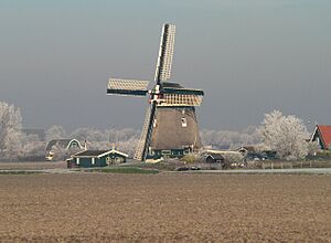
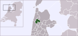
Harenkarspel (Dutch pronunciation: [ˈɦaːrə(ŋ)ˌkɑrspəl]) was a small area in the Netherlands. It was located in the province of North Holland. This region is also known as West-Frisia. The main town in Harenkarspel was Tuitjenhorn. In 2013, Harenkarspel joined with two other areas. These were Schagen and Zijpe. Together, they formed a new, larger municipality. This new municipality is still called Schagen.
Towns and Villages of Harenkarspel
The former municipality of Harenkarspel was made up of several towns and villages. These communities worked together. The town hall for Harenkarspel was located in Tuitjenhorn.
Main Communities
The largest towns in Harenkarspel were Warmenhuizen and Tuitjenhorn. These two places had the most people. They were important centers for the area.
Other Villages
Many other villages were part of Harenkarspel. They each had their own unique character. These villages included:
- Dirkshorn
- Eenigenburg
- Groenveld
- Kalverdijk
- Kerkbuurt
- Krabbendam
- 't Rijpje
- Schoorldam (partly)
- Sint Maarten
- Stroet
- Valkkoog
- Waarland
See also
In Spanish: Harenkarspel para niños
 | Selma Burke |
 | Pauline Powell Burns |
 | Frederick J. Brown |
 | Robert Blackburn |


