Zijpe facts for kids
Quick facts for kids
Zijpe
|
|||
|---|---|---|---|
|
Former municipality
|
|||
|
|||
 |
|||
| Country | Netherlands | ||
| Province | North Holland | ||
| Municipality | Schagen | ||
| Area
(2006)
|
|||
| • Total | 113.35 km2 (43.76 sq mi) | ||
| • Land | 95.17 km2 (36.75 sq mi) | ||
| • Water | 18.18 km2 (7.02 sq mi) | ||
| Population
(1 January 2007)
|
|||
| • Total | 11,565 | ||
| • Density | 122/km2 (320/sq mi) | ||
| Source: CBS, Statline. | |||
| Time zone | UTC+1 (CET) | ||
| • Summer (DST) | UTC+2 (CEST) | ||
| Website | www.zijpe.nl | ||
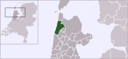
Zijpe was a special area in the Netherlands. It was located in the province of North Holland. Think of it like a town or district that used to be on its own.
In 2013, Zijpe joined with another area called Harenkarspel. They both became part of a larger municipality named Schagen. So, Zijpe is no longer a separate municipality today.
About Zijpe
Zijpe was once a municipality, which is a type of local government area. It was known for its beautiful landscapes. These included wide open fields and coastal areas.
The area covered about 113 square kilometers. A large part of this was land, around 95 square kilometers. The rest was water.
Villages in Zijpe
Before it merged, Zijpe was made up of several smaller towns and villages. These communities were all part of the Zijpe municipality. Each had its own unique charm.
Here are some of the villages that were part of Zijpe:
- Burgerbrug
- Burgervlotbrug
- Callantsoog
- Groote Keeten
- Oudesluis
- Petten
- Schagerbrug
- Sint Maartensbrug
- Sint Maartensvlotbrug
- 't Zand
These villages are now part of the Schagen municipality. They still keep their individual identities.
See also
 In Spanish: Zijpe para niños
 | Selma Burke |
 | Pauline Powell Burns |
 | Frederick J. Brown |
 | Robert Blackburn |


