Haring, Michigan facts for kids
Quick facts for kids
Haring, Michigan
|
|
|---|---|

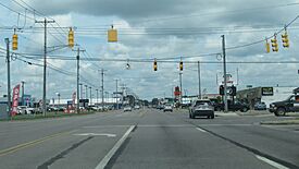
Looking north along Bus. US 131 at Bell Road
|
|

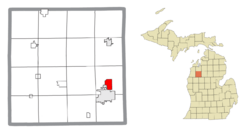
Location within Wexford County
|
|
| Country | United States |
| State | Michigan |
| County | Wexford |
| Township | Haring |
| Settled | 1882 |
| Area | |
| • Total | 2.31 sq mi (5.99 km2) |
| • Land | 2.31 sq mi (5.99 km2) |
| • Water | 0.00 sq mi (0.00 km2) |
| Elevation | 1,325 ft (404 m) |
| Population
(2020)
|
|
| • Total | 335 |
| • Density | 144.90/sq mi (55.95/km2) |
| Time zone | UTC-5 (Eastern (EST)) |
| • Summer (DST) | UTC-4 (EDT) |
| ZIP code(s) |
49601 (Cadillac)
|
| Area code(s) | 231 |
| GNIS feature ID | 1620128 |
Haring is a small community in Wexford County, Michigan, USA. It's called an "unincorporated community" and a "census-designated place" (CDP). This means it's a recognized area with its own population count, but it doesn't have its own local government like a city or town.
In 2020, about 335 people lived in Haring. It's located inside Haring Charter Township, just north of the city of Cadillac.
Contents
History of Haring
Haring was first settled around 1872. It grew up around a mill run by George A. Mitchell and Johnathon Cobbs. The community also became a railway station next to Clam Lake, which is now known as Lake Cadillac.
When a post office was opened on December 18, 1872, the early community was called Linden. Later, both the post office and the community were renamed Haring, taking the name from the township it's in. The post office stayed open until November 14, 1891.
For the first time, Haring was officially listed as a "census-designated place" for the 2010 census. This means it now has clear boundaries and its own population numbers recorded by the government.
Geography of Haring
Haring is located in Wexford County. According to the U.S. Census Bureau, the community covers an area of about 2.31 square miles (5.99 square kilometers). All of this area is land.
Major Roads in Haring
- US 131 is a main highway that runs from south to north through the eastern part of Haring.
- Bus. US 131 is a business route. It goes through the city of Cadillac and then north into Haring.
Population and Demographics
The population of Haring has been counted during the U.S. Census.
| Historical population | |||
|---|---|---|---|
| Census | Pop. | %± | |
| 2010 | 328 | — | |
| 2020 | 335 | 2.1% | |
| U.S. Decennial Census | |||
Education in Haring
Students in Haring attend schools that are part of the Cadillac Area Public Schools district. These schools are located to the south in the city of Cadillac.
See also
 In Spanish: Haring (Míchigan) para niños
 | Frances Mary Albrier |
 | Whitney Young |
 | Muhammad Ali |


