Harker's Run (Ohio) facts for kids
Quick facts for kids Harker's Run |
|
|---|---|

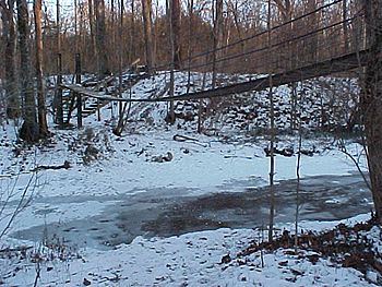
Winter Scene 2002-2003
|
|
| Country | United States |
| Physical characteristics | |
| Main source | Preble County, Ohio, US 1,000 feet (305 m) |
| River mouth | Four Mile Creek, Ohio, US |
| Length | 4.8 miles (7.7 km) |
Harker's Run is a small stream in Ohio, United States. It starts in Preble County. This stream flows into a larger one called Four Mile Creek. You can find where they meet near Miami University in Oxford.
Harker's Run flows mostly from north to south. It is about 5.5 miles (8.9 km) (8.9 km) long. The lowest part of the stream is about 775 feet (236 m) (236 meters) above sea level. Its highest point is around 1,000 feet (305 m) (305 meters) high. Several bridges cross Harker's Run. These include bridges on Bonham Road and Oxford Germantown Road.
Contents
Exploring Harker's Run
Much of Harker's Run flows through the Bachelor Wildlife and Game Reserve. This special area is owned by Miami University. It is a great place to explore nature.
The Bachelor Reserve
The reserve was once owned by a man named Joseph M. Bachelor. He was an English professor at Miami University. When he passed away in 1947, he gave his land to the university. This gift helped create the reserve we know today.
Hiking and the Swinging Bridge
The Bachelor Reserve has many hiking trails. These trails let people explore the area. One exciting part is a 45 feet (14 m) (14-meter) long swinging bridge. It crosses right over Harker's Run. It's a fun spot for hikers to visit.
Where Harker's Run Meets Four Mile Creek
Harker's Run joins Four Mile Creek about 0.25 miles (0.40 km) (0.4 km) south of the old Zachariah Price Dewitt Cabin. This cabin is a historic landmark. It's interesting to see where the smaller stream flows into the larger creek.
 | Jessica Watkins |
 | Robert Henry Lawrence Jr. |
 | Mae Jemison |
 | Sian Proctor |
 | Guion Bluford |

