Harleyville, South Carolina facts for kids
Quick facts for kids
Harleyville, South Carolina
|
|
|---|---|

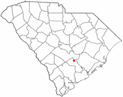
Location of Harleyville, South Carolina
|
|
| Country | United States |
| State | South Carolina |
| County | Dorchester |
| Incorporated | 1893 |
| Area | |
| • Total | 1.06 sq mi (2.75 km2) |
| • Land | 1.06 sq mi (2.75 km2) |
| • Water | 0.00 sq mi (0.00 km2) |
| Elevation | 89 ft (27 m) |
| Population
(2020)
|
|
| • Total | 666 |
| • Density | 627.12/sq mi (242.07/km2) |
| Time zone | UTC-5 (Eastern (EST)) |
| • Summer (DST) | UTC-4 (EDT) |
| ZIP code |
29448
|
| Area code(s) | 843, 854 |
| FIPS code | 45-32335 |
| GNIS feature ID | 1223038 |
Harleyville is a small town located in Dorchester County, South Carolina, in the United States. It's part of the larger Charleston-North Charleston-Summerville metropolitan area. In 2010, about 677 people lived here, and by 2020, the population was 666.
Contents
History of Harleyville
Harleyville got its name from the Harley family, who were important in the area's early days. The town was officially started in 1893.
One important historical spot near Harleyville is the St. Paul Camp Ground. This special place was added to the National Register of Historic Places in 1998. This means it's recognized as a significant historical site worth protecting.
Geography and Location
Harleyville is found in the northern part of Dorchester County. It sits at these coordinates: 33°12.7′N 80°26.9′W / 33.2117°N 80.4483°W.
Roads and Travel
Several roads help people travel to and from Harleyville. U.S. Route 178 goes right through the middle of town. You can take it northwest about 31 miles (50 km) to Orangeburg. If you go southeast for about 7 miles (11 km), it ends at U.S. Route 78.
South Carolina Highway 453 heads north from Harleyville for about 1 mile (1.6 km). This road connects to Exit 177 on Interstate 26. From I-26, you can go northwest about 68 miles (109 km) to Columbia. Or, you can travel southeast about 45 miles (72 km) to reach Charleston.
Town Size
The United States Census Bureau says that Harleyville covers an area of about 1.06 square miles (2.75 square kilometers). All of this area is land, with no large bodies of water inside the town limits.
Nearby Nature
Just outside Harleyville, you'll find the amazing Audubon's Francis Beidler Forest. This forest is a great place to explore nature. It has many miles of boardwalks that let you walk through an old swamp area called the Four Hole Swamp. It's a perfect spot for nature lovers!
Population and People
Harleyville has seen its population change over the years. Here's how the number of people living in the town has grown and changed:
| Historical population | |||
|---|---|---|---|
| Census | Pop. | %± | |
| 1900 | 248 | — | |
| 1910 | 295 | 19.0% | |
| 1920 | 353 | 19.7% | |
| 1930 | 371 | 5.1% | |
| 1940 | 381 | 2.7% | |
| 1950 | 483 | 26.8% | |
| 1960 | 561 | 16.1% | |
| 1970 | 704 | 25.5% | |
| 1980 | 606 | −13.9% | |
| 1990 | 633 | 4.5% | |
| 2000 | 594 | −6.2% | |
| 2010 | 677 | 14.0% | |
| 2020 | 666 | −1.6% | |
| U.S. Decennial Census | |||
In 2010, there were 693 people living in Harleyville. These people lived in 250 different homes. About 31.2% of these homes had children under 18 living there. The average number of people in each home was about 2.38.
The town's population was made up of different age groups. About 28.3% of the people were under 18 years old. About 16% of the people were 65 years old or older. The average age of people in Harleyville was 38 years old.
See also
 In Spanish: Harleyville (Carolina del Sur) para niños
 | Calvin Brent |
 | Walter T. Bailey |
 | Martha Cassell Thompson |
 | Alberta Jeannette Cassell |

