Hatfield, Arkansas facts for kids
Quick facts for kids
Hatfield, Arkansas
|
|
|---|---|

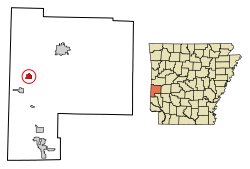
Location of Hatfield in Polk County, Arkansas.
|
|
| Country | United States |
| State | Arkansas |
| County | Polk |
| Area | |
| • Total | 1.36 sq mi (3.51 km2) |
| • Land | 1.33 sq mi (3.46 km2) |
| • Water | 0.02 sq mi (0.06 km2) |
| Elevation | 978 ft (298 m) |
| Population
(2020)
|
|
| • Total | 345 |
| • Density | 258.62/sq mi (99.82/km2) |
| Time zone | UTC-6 (Central (CST)) |
| • Summer (DST) | UTC-5 (CDT) |
| ZIP code |
71945
|
| Area code(s) | 870 |
| FIPS code | 05-30700 |
| GNIS feature ID | 2406653 |
Hatfield is a small town located in western Polk County, Arkansas, in the United States. In 2010, about 413 people lived there.
Contents
Where is Hatfield Located?
Hatfield is found at specific coordinates: 34 degrees, 29 minutes, 13 seconds North and 94 degrees, 22 minutes, 42 seconds West. This helps people find it on a map.
The United States Census Bureau says that Hatfield covers a total area of about 3.5 square kilometers (or 1.36 square miles). All of this area is land.
Who Lives in Hatfield?
| Historical population | |||
|---|---|---|---|
| Census | Pop. | %± | |
| 1920 | 335 | — | |
| 1930 | 382 | 14.0% | |
| 1940 | 437 | 14.4% | |
| 1950 | 364 | −16.7% | |
| 1960 | 337 | −7.4% | |
| 1970 | 377 | 11.9% | |
| 1980 | 410 | 8.8% | |
| 1990 | 414 | 1.0% | |
| 2000 | 402 | −2.9% | |
| 2010 | 413 | 2.7% | |
| 2020 | 345 | −16.5% | |
| U.S. Decennial Census | |||
In 2000, there were 402 people living in Hatfield. These people made up 163 households and 106 families. On average, there were about 114 people per square kilometer.
Most people in Hatfield (about 95.5%) were White. A smaller number were Native American or from two or more racial backgrounds. About 1.2% of the people were Hispanic or Latino.
About 28.8% of households had children under 18 living with them. Many households (52.8%) were married couples. About 31.9% of all households were individuals living alone.
The average age of people in Hatfield was 39 years old. About 25.4% of the population was under 18. Another 18.7% were 65 years old or older.
In 2000, the average income for a household in Hatfield was about $19,412 per year. For families, the average income was around $23,750. About 25.6% of the town's population lived below the poverty line. This included 44.7% of children under 18.
Hatfield's Climate
The weather in Hatfield is known for its hot, humid summers. Winters are usually mild to cool. This type of weather is called a humid subtropical climate. On climate maps, it's often shown as "Cfa."
Learning in Hatfield
Students living in Hatfield attend schools that are part of the Mena School District.
Before July 1, 2004, Hatfield had its own school district. However, it later joined with the Mena School District.
Getting Around Hatfield
Hatfield itself does not have its own public transportation system. However, you can find intercity bus services provided by Jefferson Lines in the nearby town of Mena.
Other Interesting Facts
The main office for the Christian Motorcyclists Association is located in Hatfield. This is an organization for motorcyclists who share a Christian faith.
See also
 In Spanish: Hatfield (Arkansas) para niños
 | Jessica Watkins |
 | Robert Henry Lawrence Jr. |
 | Mae Jemison |
 | Sian Proctor |
 | Guion Bluford |

