
Hatherton Canal facts for kids
Quick facts for kids Hatherton Canal |
|
|---|---|

Accommodation bridge accessed from the Roman Way Hotel, at eastern limit of public access
|
|
| Specifications | |
| Locks | 21 |
| Status | part extant |
| History | |
| Date of first use | 1841 |
| Date completed | 1863 |
| Date closed | 1949 |
| Geography | |
| Start point | Calf Heath |
| End point | Churchbridge |
| Connects to | Staffordshire and Worcestershire Canal, Cannock Extension Canal |
The Hatherton Canal is an old canal in south Staffordshire, England, that is no longer used. It was built in two main parts. The first part opened in 1841 and connected to the Staffordshire and Worcestershire Canal. From there, a special railway line called a tramway carried coal from the Great Wyrley mines.
The second part was a joint project with another canal company. It linked the canal to the Cannock Extension Canal in 1863. This part had 13 locks to help boats go up and down hills. The canal was very busy carrying coal and was used until 1949. It was officially closed in 1955. After it closed, some parts of the canal were destroyed by open-pit coal mining.
People started planning to bring the canal back to life in 1975. A group called the Lichfield and Hatherton Canals Restoration Trust was formed in 1989. They have worked hard to protect and restore the canal. The canal's path was even threatened by the M6 Toll motorway. But the Trust worked with the road builders to make two special tunnels, called culverts, for the canal to pass through.
In 2009, a study suggested a new path for the destroyed part of the canal. This new path would connect to the Wyrley and Essington Canal. Restoring the canal and building the new path was estimated to cost about £44.1 million in 2009. A small part of the canal near the Staffordshire and Worcestershire Canal is still open for boats.
Contents
History of the Hatherton Canal
The Hatherton Canal was built in two stages by different canal companies. The first part was built by the Staffordshire and Worcestershire Canal Company. It ran from Hatherton Junction at Calf Heath to Churchbridge. This part was about 3.5 miles (5.6 km) long and had eight locks.
There were ideas for a tramway in 1798 to connect to coal mines. The canal company used these ideas for their own surveys in the 1820s and 1830s. The canal company did not get a special law from Parliament to build it. Instead, they bought all the land they needed directly from the landowners. Construction began in 1839 and finished in April 1841. A tramway to carry coal from Great Wyrley was finished the next year. The canal company was very rich at the time, so they paid for the canal and tramway from their own money. The canal was named the Hatherton Branch after Lord Hatherton, who was the company chairman.
Connecting to Other Canals
The second part of the canal was a team effort between the Staffordshire and Worcestershire Canal and the Birmingham Canal Navigations Company. The Birmingham Canal Navigations Company was planning to build the Cannock Extension Canal. This new canal would reach more coal mines near Cannock.
In 1854, the two companies agreed to build 13 locks between the Hatherton Branch and the Cannock Extension Canal at Churchbridge. The Staffordshire and Worcestershire Canal Company paid for building these locks. They were built in 1858 and 1859. However, they probably weren't used until 1863, when the Cannock Extension Canal was completed. This new section created a useful route for boats around the northern part of the Birmingham area. The total length of both parts of the Hatherton Canal was about 4 miles (6.4 km).
End of the Canal
The canal was very busy. In 1902, about 12,000 tons of coal were moved down the Churchbridge locks each month. By 1905, the Staffordshire and Worcestershire Canal carried 722,000 tons of goods. About 225,000 tons of this was coal, mostly from the Cannock coalfields.
However, the coal mining also caused problems for the canal. In the 1940s, the ground started to sink because of the mining. This sinking, called subsidence, damaged the canal. Commercial boats stopped using the canal in 1950. It was officially closed in 1955. In the 1950s, parts of the canal, including the Churchbridge locks, were completely destroyed by open-pit coal mining. These areas have since been rebuilt for other uses.
Restoring the Hatherton Canal
The idea to restore the canal first came up in 1975. A group called the Ogley and Hatherton Restoration Society was formed in 1989. This group later became the Lichfield and Hatherton Canals Restoration Trust. They worked to save the canal's path, especially when the M6 Toll motorway was being planned.
In 1995, the M6 motorway was going to be made wider. The plans did not include a way for the canal to cross under the widened motorway. The Trust worked hard to talk with the people building the M6 Toll motorway. Building special tunnels for boats would cost a lot of money. But an agreement was reached. The Trust raised £150,000 for one tunnel, and the government paid for the main tunnel under the motorway.
New Plans for the Canal
Today, the canal is part of an active restoration project. A study done in 2006 suggested a new path for the destroyed Churchbridge section. This path would have new locks and connect to Grove Basin on the Cannock Extension Canal.
However, this route was not chosen. The Cannock Extension Canal is a special protected area because it has a rare plant called floating water plantain. So, a new study in 2009 found a different route. This new path would connect to the Wyrley and Essington Canal through an old branch called the Lord Hayes Branch. This route is better for the environment and local landowners. It also means fewer new road bridges are needed.
Experts have estimated that rebuilding the canal, including the new section, will cost about £44.1 million. Even though this new route is a bit longer, it costs less. This is because the other route would have gone through land that was polluted by old coal mining waste. Both new routes will use the special tunnels already built under the A5 road and the M6 Toll motorway.
The Canal's Path

The Hatherton Canal starts at Calf Heath, connecting to the Staffordshire and Worcestershire Canal. There is a large boat marina near the start. After the marina, a small road crosses the canal, and then you reach the first lock. Above this lock, the canal widens, offering more space for boats to tie up. The second lock has been changed to include a dry dock for boat repairs.
Beyond the second lock, there is a section that could be dug out to make it usable again. However, the M6 motorway now crosses this part. A small tunnel lets water flow under the motorway, but it's not big enough for boats. Luckily, the motorway is high enough that a larger tunnel for boats could be built.
Further along, Scrawpers End Bridge carries Oak Lane over the canal. This bridge has been lowered, so there's only about 4 feet (1.2 m) of space underneath. A new lift bridge might be needed here. Next, there's a feeder from Gailey reservoirs. This feeder keeps water in the canal, which then supplies the main Staffordshire and Worcestershire Canal.
Saredon Mill bridge is in good shape because volunteers rebuilt its walls. Much work has been done to clear trees and fix the path next to the canal, making it a nice walking route. Cross Bridge has also been lowered. It carries a lot of traffic, so a lift bridge is not an option here. The canal here still has water and is almost ready for boats. Cats Bridge was replaced by a tunnel after the ground sank. An old bridge beyond it was taken down by the Trust because it was cracked and sinking. It won't be replaced as it's no longer needed.
A small river called Saredon Brook adds more water to the canal before Meadow Lock. This lock is mostly whole, even though it sank a bit before the canal closed. Volunteers have cleared the path above the lock. This allows walkers to reach a bridge behind the Roman Way Hotel. A lot of work has been done to build a ramp to the path and fix this bridge.
The A4601 road crosses at Wedge Mills Bridge. The original bridge and a lock were destroyed when the road was made wider. Joveys Lock was quite shallow. It is now part of the Wyrley Brook, which was moved to make space for a sewage plant. The next two locks, Rosemary's and Walkmill, are now under an industrial estate.
Great Wyrley Basin was in this area, as was Hawkins Basin. Hawkins Basin was connected to the canal by a channel. This channel had a path bridge and a lift bridge. It also crossed the Wyrley Brook on a bridge-like structure called an aqueduct. This aqueduct was found when the M6 Toll motorway was built, but it was destroyed during that project. It will not be possible to rebuild the canal exactly here. So, a new path to the south of the original line is planned.
The area where the Churchbridge locks were located was dug up by open-pit mining in the 1950s. The canal's path there is completely gone. The local council owns some land between the A5 road and the M6 Toll motorway. This land has been chosen as a good place for a new section of the canal.
Proposed New Route

From Churchbridge, the planned new route follows the A5 road on council land. It then turns south near the motorway tollbooths. It follows the Wash Brook valley for about 1.9 miles (3 km). After that, a 1,000-yard (910 m) section climbs up to join the filled-in Lord Hayes Branch. This is about 330 yards (300 m) from where it meets the Wyrley and Essington Canal. This last part of the Lord Hayes Branch will be fixed up.
Most of the locks on this new route will lower boats by about 9.2 feet (2.8 m). After Holford Lock and Gains Lock, the route turns east. A farm track will cross here on a lift bridge. The canal then goes along the edge of an old coal waste pile. It also crosses over the Wash Brook, which will go through a tunnel under the canal.
To cross some fields, the canal will be built in a 10-foot (3 m) deep trench. Further on, the canal will be built on raised banks. The dirt dug from the trench will be used to build these banks. A fixed bridge will carry an access track over the canal. Then the canal will pass under Gains Lane. This road will need to be raised by about 7 feet (2.1 m) to allow boats to pass underneath. The canal will then cross Wash Brook again. This section is very important because of how close it is to the road and the brook.
A public walking path crosses the route, and it will be moved to follow the canal's path. A farm track will cross a tunnel, which will be changed so the tunnel can go under the canal. Another public path, Cadman's Lane, will be moved to cross the canal at the next lock.
Three locks follow: Dark Lane, Pylon, and Cadman's. Pylon Lock is named because it's near a large electricity pylon. At Cadman's Lock, a farm track will go over the end of the lock. A nearby ditch will go under the canal to keep water levels correct. The canal then crosses Cadman's Lane again. This lane will be moved for a distance along the canal path. This helps with the problem that the lane often floods. Wash Brook Lock will have a bridge over its end for Cadman's Lane to rejoin its old route. Beyond this lock, the canal will be built on a raised bank, which will be about 16 feet (4.9 m) high in some places.
The last part of the route includes Golfers Lock, near a golf range, and Colliery Lock, near old mine shafts. It then curves to join the Lord Hayes Branch, leading to the Wyrley and Essington Canal. Fishley Lane bridge crosses this section and could be fixed up. The path next to the canal is on the other side of the Wyrley and Essington. The special "roving bridge" that served the Lord Hayes Branch still exists. The path next to the canal will usually be 10 feet (3 m) wide. But in some places, it might be 13 feet (4 m) wide. This wider path would allow special cranes to access the canal. These cranes make it much easier to replace lock gates.
Images for kids
-
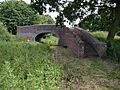
Accommodation bridge accessed from the Roman Way Hotel, at eastern limit of public access
-
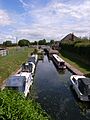
Marina and Locks 1 and 2 at Calf Heath
-
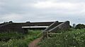
Fishley Lane Bridge on the Lord Hayes Branch, through which the new route will pass
