
Staffordshire and Worcestershire Canal facts for kids
Quick facts for kids Staffordshire and Worcestershire Canal |
|
|---|---|

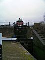
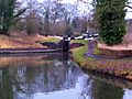
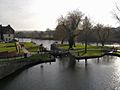
Kidderminster Lock on the Staffordshire and Worcestershire Canal
|
|
| Specifications | |
| Length | 46 miles (74 km) |
| Maximum boat length | 70 ft 0 in (21.34 m) |
| Maximum boat beam | 7 ft 0 in (2.13 m) |
| Locks | 43 |
| History | |
| Principal engineer | James Brindley |
| Date of act | 14 May 1766 |
| Date of first use | 1772 |
| Date completed | 1771 |
| Geography | |
| Start point | River Severn |
| End point | Trent and Mersey Canal |
The Staffordshire and Worcestershire Canal is a narrow canal that boats can use. It is found in Staffordshire and Worcestershire in the English Midlands. The canal is about 46 miles (74 km) long. It connects the River Severn at Stourport-on-Severn in Worcestershire with the Trent and Mersey Canal near Great Haywood.
Contents
The Canal's Story
How the Canal Was Built
James Brindley was the main engineer for this canal. It was part of his big plan called the "Grand Cross". This plan aimed to link major ports like Hull, Liverpool, Bristol, and London using waterways.
A special law, called an Act of Parliament, was passed on May 14, 1766. This law allowed the canal to be built. It also created a company to manage the canal. This company could raise money to pay for the building work.
The canal was finished in 1771 and opened for trade in 1772. It cost more than planned but was very successful. Goods like pottery from Staffordshire Potteries traveled south to Gloucester and Bristol. Goods from the Black Country went north to the Potteries.
Facing Competition
In 1815, the newer Worcester and Birmingham Canal opened. This canal offered a shorter way between Birmingham and Bristol. Because of this, the Staffordshire and Worcestershire Canal started to lose business. To stay competitive, the company let boats use the locks for more hours. By 1830, locks were open 24 hours a day.
Another challenge came when the Birmingham and Liverpool Junction Canal opened. This new route connected to Chester and Merseyside. It joined the Staffordshire and Worcestershire Canal at Autherley Junction. This meant less traffic on the section of the canal that went to Great Haywood. The canal company charged high fees for the short half-mile stretch between Aldersley and Autherley Junctions.
To fix this, other canal companies planned to build a new canal. This new canal would have avoided the high fees. Instead of losing all the business, the Staffordshire and Worcestershire Canal company decided to lower its fees. They made more deals later when other companies threatened to build new routes again.
Later Years and Decline
Even with new canals and later, railways, the canal company still made money for its owners. However, their profits slowly went down after the 1860s. The canal stayed independent until 1948. That year, a law called the Transport Act 1947 made all canals in Britain owned by the government.
In its later years, the main trade was coal from Cannock to a power station in Stourport. The power station closed in 1949. After that, only a small part of the canal, between Autherley and Aldersley Junctions, was used for commercial boats.
Saving the Canal
In 1959, the British Transport Commission planned to close the canal. But a group of volunteers, called the Staffordshire and Worcestershire Canal Society, saved it. In 1968, the canal was made a "cruiseway," meaning it was mainly for leisure boats. The next year, the whole canal was named a Conservation Area. This means that old buildings and structures along the canal are protected and kept in good condition.
The Canal's Path
A Key Waterway Link
The Staffordshire and Worcestershire Canal connects two of southern Britain's largest river systems:
- The Trent system: This river drains much of the north and east of the English Midlands. It flows into the North Sea through the Humber Estuary.
- The Severn system: This river drains a large part of Wales and the West Midlands. It flows into the Celtic Sea through the Bristol Channel.
The canal was a very important route for trade in the west of England. It linked other canals to create a large network:
- Through the Trent and Mersey Canal, it connected to Stoke-on-Trent and the northwest of England.
- Through the BCN Main Line and the Stourbridge Canal, it connected to the Black Country and Birmingham.
- Through the Shropshire Union Canal, it connected to Chester and north Wales.
The canal mostly follows river valleys. It crosses the land between the Trent and Severn rivers near Wolverhampton. This area, called the Aldersley Gap, was a natural dip in the land that Brindley used to his advantage.
Journey Through the Trent Area
The canal starts in the north at Great Haywood. This is where it meets the Trent and Mersey Canal. This spot is very close to where the River Sow joins the River Trent. The canal goes west through Tixall Wide and along the Sow valley. It follows the river closely to Weeping Cross, near Stafford. Here, the River Penk joins the Sow.
The canal then turns sharply south, following the path of the Penk. It passes through Acton Trussell and Penkridge to Calf Heath. Here, the Hatherton Canal joins it (this canal is currently not used but might be fixed up). The canal continues south past Coven. It then moves away from the Penk, which starts further west. The canal enters the northwest part of Wolverhampton. Here, it quickly meets two other canals: the Shropshire Union Canal at Autherley Junction and the BCN Main Line at Aldersley Junction.
Journey Through the Severn Area
South of Aldersley, the canal follows the River Smestow. This river is part of the Severn system. The Smestow Brook actually flows over the canal using a small bridge called the Dunstall Water Bridge. Brindley designed this to keep the river flowing. After that, the canal runs alongside the river.
The canal goes around Wolverhampton, between the hills of Compton and Tettenhall. It passes through the Smestow Valley Local Nature Reserve and reaches Wightwick. Here, it turns south, cutting across a large bend in the Smestow. The canal goes down steeply through the impressive Bratch locks. It then meets the River Smestow again just south of Wombourne. From here, it follows the river very closely until it meets the Stour near Prestwood.
Where the Smestow and Stour rivers meet, the Staffordshire and Worcestershire Canal also meets the Stourbridge Canal. The Stourbridge Canal goes down through locks to Stourton. South from this point, the canal is cut through very steep sandstone banks. It also goes through a tunnel at Dunsley. All the way, it follows the river closely, cutting across its many bends.
The canal passes through Kinver, Caunsall, Cookley, and Wolverley. It has many wharves (places for boats to load and unload) in the old industrial town of Kidderminster. Finally, it ends in a busy area of wharves and basins in the canal town of Stourport-on-Severn. Here, it goes down steeply to the river through two sets of locks.
Linked Canals
The Staffordshire and Worcestershire Canal connects to other canals. These are listed in order, starting from the River Severn end:
- Stourbridge Canal at Stourton Junction
- BCN Main Line at Aldersley Junction
- Shropshire Union Canal at Autherley Junction
- Hatherton Canal, which is currently not used but might be fixed up, at Hatherton Junction
Today, the canal is part of the Stourport Ring. This is a popular route for people who enjoy boating for fun. It is also part of the Four Counties Ring.
Images for kids
-
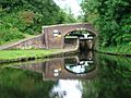
Bridge 105: a changeline bridge near Milford.
-
Hatherton Junction, where the Hatherton Canal meets the Staffordshire and Worcestershire Canal at Calf Heath.
-
Pendeford Rockin' or 'The Narrows', where the canal cuts through rock at Pendeford.
-
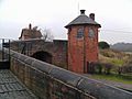
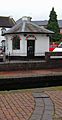
Toll houses at Autherley Junction, where the Shropshire Union Canal meets the canal.
-
Aldersley Junction: the bottom lock of the Wolverhampton flight of the BCN Main Line is visible.
-
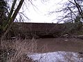
The Dunstall Water Bridge carries the Smestow Brook over the canal.
-
The Dunstall water Bridge viewed from the canal side.
-
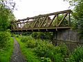
The "Meccano Bridge", a steel bridge carrying a walking path over the canal in Smestow Valley.
-
Part of the Bratch Locks at Wombourne.
-
Toll House and upper bridge at the Bratch Locks.
-
Hinksford Wharf, an important mooring place on this part of the canal.
-
Bridge and pumping station at Hinksford.
-
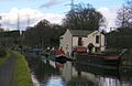
Marina in the canal basin at Ashwood, Staffordshire.
-
Sandstone aqueduct, carrying the canal over the River Stour, near Prestwood.
-
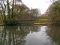
Lake off the canal, near Prestwood, north of Stourton.
-
Steep cutting and workings in sandstone, north of Stourton.
-
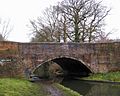
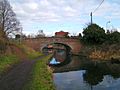
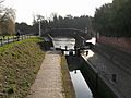
Stourton Junction: the Stourbridge Canal goes down through locks to meet the Staffordshire and Worcestershire.
-
The old toll house at Stewponey Lock.
-
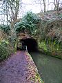
West entrance of the Dunsley Tunnel, between Stourton and Kinver.
-
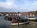
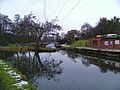
Upper basin at Stourport-on-Severn. This area was greatly improved from 2007-2009.
-
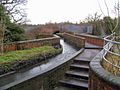
Broad lock connecting the canal with the River Severn at Stourport.
-
Narrow staircase locks connecting the canal with the River Severn at Stourport.
-
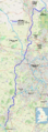
Map of the canal and connecting waterways (zoom in for detail)


