
Hayden Island, Portland, Oregon facts for kids
Quick facts for kids
Hayden Island
|
|
|---|---|
|
Neighborhood
|
|
 |
|
| Country | |
| State | |
| City | |
| Area | |
| • Total | 1.69 sq mi (4.38 km2) |
| Population
(2000)
|
|
| • Total | 2,130 |
| • Density | 1,260/sq mi (486.3/km2) |
| Housing | |
| • No. of households | 1224 |
| • Occupancy rate | 84% occupied |
| • Owner-occupied | 1012 households (83%) |
| • Renting | 212 households (17%) |
| • Avg. household size | 1.74 persons |
Hayden Island is a cool island located in the Columbia River. It sits right between Vancouver, Washington, and Portland, Oregon. The main part of the Columbia River, which is also the border between Washington and Oregon, flows north of the island. South of the island, there's a smaller channel called North Portland Harbor. Most of Hayden Island, along with Tomahawk Island to its east, is part of Portland. It's known as one of Portland's 95 neighborhoods.
The only road connecting Hayden Island to the mainland is Interstate 5. This highway links the island to North Portland and, via the Interstate Bridge, to Vancouver, Washington. A railway also crosses the island, heading west of I-5, before crossing the Columbia River. The eastern part of the island, often called Jantzen Beach, has lots of shops, hotels, offices, and homes. Further east, you can find many houseboat communities and places to dock boats, called marinas.
Before the Interstate Bridge opened in 1917, people used ferries to travel between Portland and Vancouver from the island's north shore. After the bridge was built, streetcars made Hayden Island a popular spot for amusement parks. This was because of its nice beaches and great location. The last amusement park, Jantzen Beach, closed in 1970. Another park, Lotus Isle, was on Tomahawk Island for a few years in the 1930s.
Oregon does not have a state sales tax, but Washington does. Because of this, many people from Southwest Washington travel to Oregon to buy things, especially bigger items. The Jantzen Beach Shopping Center and many hotels on Hayden Island are popular for this reason. A narrow piece of land connects Hayden Island to Tomahawk Island. Tomahawk Island is now home to many marinas, yacht clubs, and apartments.
The western side of Hayden Island is still mostly undeveloped. The Port of Portland bought this land in 1993. They planned to build a large cargo facility there. However, this area is also important for wildlife. Environmental groups have worked to protect it. In 2010, the Portland City Council decided to study a plan that would allow about 300 acres (1.2 km2) for a port facility. The remaining 500 acres (2.0 km2) would be kept as a protected natural area.
Island's Past: A Look at History
In 1792, a British explorer named Lieutenant William Robert Broughton found the island. He named it Menzies. Later, in 1805, the famous explorers Lewis and Clark called it Image Canoe Island. This was because they saw a large canoe decorated with images of people and animals come from the other side of the island.
The Hudson's Bay Company once called it Vancouver Island. In the early 1800s, it was known as Shaw Island. This was after Colonel W. Shaw, who owned land there. In 1851, the island got its current name, Hayden Island. It was named after Gay Hayden, an early settler who moved there in 1851. He built a big home and lived on the island for five years with his wife, Mary Jane Hayden, and their twin children.
-

Sand dunes on Hayden Island in 1973.
-
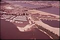
A Bird's-eye view of Hayden Island and the Interstate Bridge in 1973.
-
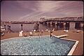
The Thunderbird Motel on Hayden Island in 1973.


Future Plans: Developing the Island
Since 2008, the Port of Portland has been planning how to develop the western part of Hayden Island. Their plan aims to balance new industrial uses with protecting nature. The idea is to develop about 300 acres (1.2 km2) for businesses and keep 500 acres (2.0 km2) as a natural area. This plan has been discussed a lot, especially by environmental groups like the Audubon Society of Portland, who want to protect the natural spaces.
The city of Portland asked a group called ECONorthwest to study the economic effects of this development. The study looked at what would happen if the land was developed versus if it stayed natural. It found that developing the land would likely bring more economic benefits than leaving it untouched. This means more jobs and money for the area.
