North Portland Harbor facts for kids
Quick facts for kids North Portland Harbor |
|
|---|---|

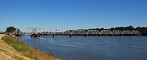
Railroad bridge over the channel
|
|
|
Location of the mouth of North Portland Harbor in Oregon
|
|
| Country | United States |
| State | Oregon |
| County, City | Multnomah, Portland |
| Physical characteristics | |
| Main source | Columbia River about 108 miles (174 km) from the Columbia mouth |
| River mouth | Columbia River about 103 miles (166 km) from the Columbia mouth 10 ft (3.0 m) 45°37′48″N 122°43′54″W / 45.63000°N 122.73167°W |
| Length | 5 mi (8.0 km) |
The North Portland Harbor is a special waterway in Oregon. It's located in Multnomah County, right in the city of Portland. This channel is like a side branch of the big Columbia River.
It's about 5 miles (8.0 km) long. This waterway helps separate Hayden Island and Tomahawk Island from the main land. The channel flows generally towards the northwest. It eventually meets up with the main Columbia River again. This meeting point is just a little bit upstream from Kelley Point Park. It's also near where the Willamette River flows into the Columbia.
Contents
Bridges and Transportation
This important channel has several bridges crossing over it. These bridges help people and trains get around.
Interstate Bridge
The Interstate Bridge is a very busy bridge. It carries Interstate 5 (I-5) right over the North Portland Harbor. This highway is a major route for cars and trucks.
Railroad Bridge
Further downstream, there's another important bridge. This one is called the Oregon Slough Railroad Bridge. It's used for trains. The BNSF Railway uses this rail bridge to cross the North Portland Harbor.
Port and Roads
The North Portland Harbor is also important for shipping and trade.
Port of Portland
Along the mainland side of the channel, you'll find Terminal 6. This is part of the Port of Portland. A port terminal is a place where ships load and unload cargo. This helps move goods in and out of the area.
Northeast Marine Drive
A road called Northeast Marine Drive runs mostly alongside the channel. It follows the waterway for a good part of its length.
Other Names
The official name for this waterway is North Portland Harbor. This name is registered with the United States Board on Geographic Names. However, in the past, people used other names for it. Some of these older names include Oregon Slough and Hayden Slough.
 | Aurelia Browder |
 | Nannie Helen Burroughs |
 | Michelle Alexander |


