Haynesville, Maine facts for kids
Quick facts for kids
Haynesville, Maine
|
|
|---|---|

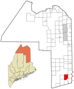
Location of Haynesville, Maine
|
|
| Country | United States |
| State | Maine |
| County | Aroostook |
| Area | |
| • Total | 41.90 sq mi (108.52 km2) |
| • Land | 41.38 sq mi (107.17 km2) |
| • Water | 0.52 sq mi (1.35 km2) |
| Elevation | 371 ft (113 m) |
| Population
(2020)
|
|
| • Total | 97 |
| • Density | 2/sq mi (0.9/km2) |
| Time zone | UTC-5 (Eastern (EST)) |
| • Summer (DST) | UTC-4 (EDT) |
| ZIP code |
04497
|
| Area code(s) | 207 |
| FIPS code | 23-32195 |
| GNIS feature ID | 0582515 |
Haynesville is a small town located in Aroostook County, Maine, in the United States. It's a quiet place with a population of 97 people, according to the 2020 census.
Contents
Exploring Haynesville's Location and Size
Haynesville is situated in the northeastern part of the United States. It's part of the state of Maine.
How Big is Haynesville?
The town covers a total area of about 41.90 square miles (108.52 square kilometers). Most of this area is land, measuring around 41.38 square miles (107.17 square kilometers). A smaller part, about 0.52 square miles (1.35 square kilometers), is covered by water.
Understanding Haynesville's Population Changes
The number of people living in Haynesville has changed quite a bit over the years. This section looks at how the population has grown and shrunk.
| Historical population | |||
|---|---|---|---|
| Census | Pop. | %± | |
| 1850 | 96 | — | |
| 1860 | 169 | 76.0% | |
| 1870 | 165 | −2.4% | |
| 1880 | 224 | 35.8% | |
| 1890 | 280 | 25.0% | |
| 1900 | 316 | 12.9% | |
| 1910 | 272 | −13.9% | |
| 1920 | 349 | 28.3% | |
| 1930 | 251 | −28.1% | |
| 1940 | 235 | −6.4% | |
| 1950 | 185 | −21.3% | |
| 1960 | 187 | 1.1% | |
| 1970 | 157 | −16.0% | |
| 1980 | 169 | 7.6% | |
| 1990 | 243 | 43.8% | |
| 2000 | 122 | −49.8% | |
| 2010 | 121 | −0.8% | |
| 2020 | 97 | −19.8% | |
| U.S. Decennial Census | |||
Population in 2010
In 2010, there were 121 people living in Haynesville. These people lived in 56 different homes. About 38 of these homes were families. The town had about 2.9 people per square mile.
There were 107 housing units in total. This means there were about 2.6 homes per square mile. Most of the people living in Haynesville were White (98.3%). A small number were Native American (0.8%) or from two or more races (0.8%). About 2.5% of the population identified as Hispanic or Latino.
Haynesville Households
Out of the 56 homes, about 17.9% had children under 18 living there. Many homes (60.7%) were married couples living together. About 7.1% of homes had a female head of household without a husband. About 32.1% of homes were not families.
Also, 32.1% of homes had only one person living there. About 10.8% of these single-person homes were people aged 65 or older. On average, each home had about 2.16 people. Families, on average, had about 2.66 people.
Age Groups in Haynesville
The average age of people in Haynesville in 2010 was 49.5 years old. Here's a breakdown of the age groups:
- 15.7% were under 18 years old.
- 4.9% were between 18 and 24 years old.
- 19% were between 25 and 44 years old.
- 45.3% were between 45 and 64 years old.
- 14.9% were 65 years or older.
More males lived in Haynesville than females in 2010. About 55.4% of the population was male, and 44.6% was female.
See also
 In Spanish: Haynesville (Maine) para niños
 | Laphonza Butler |
 | Daisy Bates |
 | Elizabeth Piper Ensley |

