
Hazelrigg, Indiana facts for kids
Quick facts for kids
Hazelrigg, Indiana
|
|
|---|---|

Grain elevators in Hazelrigg, Indiana
|
|

Boone County's location in Indiana
|
|

Hazelrigg, Indiana
Location in Boone County, Indiana
|
|
| Country | United States |
| State | Indiana |
| County | Boone |
| Township | Jefferson |
| Elevation | 912 ft (278 m) |
| Time zone | UTC-5 (Eastern (EST)) |
| • Summer (DST) | UTC-4 (EDT) |
| ZIP code |
46052
|
| Area code(s) | 765 |
| FIPS code | 18-32656 |
| GNIS feature ID | 435938 |
Hazelrigg is a small, unincorporated town located in Boone County, Indiana, in the United States. This means it's a community that isn't officially governed as a city or town, but it still has its own identity and history. It's part of Jefferson Township.
History of Hazelrigg
Hazelrigg started thanks to the railroad! In the 1860s, a local businessman named Harvey G. Hazelrigg helped create the Lafayette and Indianapolis (L&I) Railroad Company. A train station was built on his land, and it became known as Hazelrigg Station.
Over the years, the railroad changed names several times. It eventually became part of a larger system called the Cleveland, Cincinnati, Chicago and St. Louis Railway, often called the "Big Four."
This train stop attracted people, and a small community grew around it. By 1887, Hazelrigg Station was an important place for stopping and shipping goods. It had a store, a public hall, a blacksmith shop, and homes. A post office opened there on September 10, 1873.
In the early 1900s, the town, then simply called Hazelrigg, had a church and a school. It was still a key spot for shipping. There was also a small grocery store.
Around 1918, a famous poultry breeder named C. S. Byers lived in Hazelrigg. He was known for raising special kinds of chickens called Orpington chickens.
The post office in Hazelrigg closed in 1935. Years later, on April 11, 1965, a strong tornado hit Hazelrigg. It caused a lot of damage to the town and nearby areas during the Palm Sunday tornado outbreak. The governor of Indiana, Roger Branigin, even came to see the damage.
Today, Hazelrigg has a grain elevator, which is a tall building for storing grain. Other than that, it's mostly a quiet place where people live.
Geography and Location

Hazelrigg is located at 40°04′56″N 86°33′47″W / 40.08222°N 86.56306°W. You can find it near where Boone County roads 300 North (Hazelrigg Road) and 500 West meet. The area around Hazelrigg is mostly open farmland.
It's about three miles west of major roads like U.S. Route 52 and Interstate 65. The town is also about four miles southeast of Thorntown and five miles northwest of the city of Lebanon.
A path called the Big 4 Trail runs along the southwest side of Hazelrigg. This trail used to be the old railroad line. It stretches south to Lebanon and north to Colfax in Tippecanoe County. It's a great place for walking or biking!
Images for kids
-
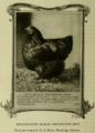
A Black Orpington hen, similar to those bred by C. S. Byers in Hazelrigg.

