
Hector and Ngakawau facts for kids
Quick facts for kids
Hector and Ngakawau
|
|
|---|---|

Ngākawau River mouth
|
|
| Country | New Zealand |
| Region | West Coast |
| District | Buller District |
| Ward | Seddon |
| Electorates |
|
| Area | |
| • Total | 2.53 km2 (0.98 sq mi) |
| Population
(June 2023)
|
|
| • Total | 190 |
| • Density | 75.1/km2 (195/sq mi) |
Hector and Ngakawau are two small towns in the West Coast region of New Zealand. They are located right where the Ngākawau River meets the sea. Both towns are on State Highway 67, which connects Westport and Karamea. Even though not many people live here, these towns are home to many workers from New Zealand's biggest open-pit coal mine at Stockton. Shuttles often travel between the towns and the mine.
Contents
Hector: Home of the Dolphins
Hector is the larger of the two towns. It is located on the northern side of the Ngākawau River mouth.
This town is special because it has adopted the endangered Hector's dolphin as its symbol. The people of Hector work with the Department of Conservation to help protect these amazing dolphins. You can often see the dolphins playing just offshore, which brings many visitors to the area. Hector also has a fun country music museum to explore.
Ngakawau: A Hub for Coal Transport
Ngakawau is on the southern side of the Ngākawau River mouth. This town is very important for the local economy, especially for moving coal.
Since 2015, Ngakawau has been the end point, or "terminus," of the Ngakawau Branch railway line. A special aerial ropeway, like a giant cable car system, brings huge amounts of coal from the Stockton Mine to Ngakawau. From here, the coal is loaded onto trains and sent to the port town of Lyttelton on the east coast of New Zealand.
The Ngakawau Railway History
The railway line from Westport to Ngakawau first opened on 12 September 1877. Later, on 8 August 1893, the line was extended north across the river through Hector to Mokihinui. It eventually reached Seddonville on 23 February 1895 and became known as the Seddonville Branch.
Trains that carried both passengers and goods, called "mixed trains," used to run through both towns. However, passenger services stopped on 14 October 1946. After that, coal was almost the only thing transported on the line. As coal production from mines further north decreased, it became too expensive to keep the northern part of the line open. So, the section north of Ngakawau was closed.
Who Lives in Hector and Ngakawau?
Statistics New Zealand describes Ngakawau as a rural settlement. This area covers about 2.53 square kilometers and includes Hector.
In the 2018 New Zealand census, Hector and Ngakawau had a population of 198 people. This was a small decrease from earlier years. There were 114 households in total. The population included 105 males and 96 females. About 9.1% of the people were under 15 years old. Most people were between 30 and 64 years old (53.0%), and 28.8% were 65 or older.
Most residents (92.4%) identified as European/Pākehā. Some people also identified as Māori (18.2%), Pasifika (1.5%), or other ethnicities. People could choose more than one ethnicity.
When asked about their religion, 59.1% said they had no religion. About 24.2% were Christian, and a small number were Buddhist or had other religions.
Of those aged 15 and older, a small number (6.7%) had a university degree. About 36.7% did not have formal qualifications. Most people aged 15 and over were employed, with 28.3% working full-time and 10.0% working part-time.
Images for kids
-
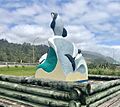
A statue of Hector's Dolphins in Hector, celebrating the town's connection to these special creatures.

