
Hemet Maze Stone facts for kids
Quick facts for kids Hemet Maze Stone |
|
|---|---|

Maze Stone with plaque
|
|
| Location | Outside Hemet in Reinhardt Canyon |
| Reference no. | 557 |
The Hemet Maze Stone is a very old rock carving, also known as a petroglyph. You can find it near Hemet, in a place called Reinhardt Canyon, within the Lakeview Mountains in Riverside County, California. This special stone and some land around it were given to Riverside County on April 16, 1956. It is now a California Historical Landmark, number 557. To keep it safe, two fences have been put up around the carving.
The land around the stone is also protected. It helps keep native plants and animals safe. There's a warning that the natural areas might have some dangers. The property is at the end of California Avenue, north of Highway 74. It's also a few miles east of Interstate 215. The road leading to the stone is now blocked. This stops cars from driving too close to the Hemet Maze Stone.
Contents
Discovering the Hemet Maze Stone
What is the Maze Stone?

The Hemet Maze Stone is a fascinating example of ancient art. It was named a California state landmark in 1956. The main part of the "maze" has two rectangular shapes. One is larger and holds the other, which is centered inside. If you follow the lines, you'll see two connected patterns between the boxes. These patterns look a lot like a maze. One "maze" is actually inside the other on the left side.
Some people think the carving shows four walled areas. These include two simple shapes and two more complex, maze-like shapes. For each type of shape, there's an inner and an outer part. This petroglyph is part of what experts call the California Engraved style. It belongs to the larger California Tradition of rock art.
Protecting a Piece of History
The stone is protected by two chain-link fences. Sadly, at some point, someone damaged the carving. They added a swastika symbol to one corner. It's important to know that the swastika has been used in many cultures for thousands of years. It appeared in art from places like Asia and by Native American groups long before World War I. The symbol added to the Hemet Maze Stone was carved counter-clockwise. The Nazis, who used the symbol after World War I, used a clockwise version.
Images for kids
-
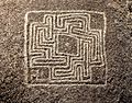
Hemet Maze Stone without distortions of viewpoint, as if from above. Width/height of maze is about 61 cm.
-
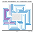
Conceptual Approximation of the Maze Stone
-
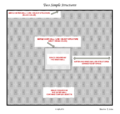
Diagram showing two possible square/rectangular walled structures or spaces derived from the pattern carved into the Hemet Maze Stone
-
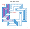
Diagram showing two possible block-like walled structures or spaces derived from the pattern carved into the Hemet Maze Stone


